canton of Vierzon-2 (canton de Vierzon-2)

- canton of France
- Country:

- Capital: Vierzon
- Coordinates: 47° 13' 21" N, 2° 4' 10" E


- GPS tracks (wikiloc): [Link]
- Population: 16545
- Wikipedia en: wiki(en)
- Wikipedia: wiki(fr)
- Wikidata storage: Wikidata: Q1727859
- Freebase ID: [/m/05sztr4]
- INSEE canton code: [1819]
Includes regions:


Vouzeron
- commune in Cher, France
- Country:
- Postal Code: 18330
- Coordinates: 47° 15' 37" N, 2° 13' 19" E
- GPS tracks (wikiloc): [Link]
- Area: 52.63 sq km
- Population: 553
- Web site: [Link]

Vignoux-sur-Barangeon
- commune in Cher, France
- Country:
- Postal Code: 18500
- Coordinates: 47° 12' 6" N, 2° 10' 18" E
- GPS tracks (wikiloc): [Link]
- Area: 24.87 sq km
- Population: 2141
- Web site: [Link]


Thénioux
- commune in Cher, France
- Country:
- Postal Code: 18100
- Coordinates: 47° 15' 23" N, 1° 55' 53" E
- GPS tracks (wikiloc): [Link]
- Area: 18.33 sq km
- Population: 669


Neuvy-sur-Barangeon
- commune in Cher, France
- Country:
- Postal Code: 18330
- Coordinates: 47° 18' 56" N, 2° 15' 14" E
- GPS tracks (wikiloc): [Link]
- Area: 67.34 sq km
- Population: 1243
Méry-sur-Cher
- commune in Cher, France
- Country:
- Postal Code: 18100
- Coordinates: 47° 14' 46" N, 1° 59' 18" E
- GPS tracks (wikiloc): [Link]
- Area: 20.91 sq km
- Population: 665
Saint-Hilaire-de-Court
- commune in Cher, France
- Country:
- Postal Code: 18100
- Coordinates: 47° 12' 24" N, 2° 1' 21" E
- GPS tracks (wikiloc): [Link]
- Area: 11.75 sq km
- Population: 613


Vierzon
- commune in Cher, France
- Country:
- Postal Code: 18100
- Coordinates: 47° 13' 19" N, 2° 4' 6" E
- GPS tracks (wikiloc): [Link]
- Area: 74.5 sq km
- Population: 26919
- Web site: [Link]
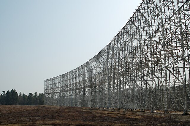
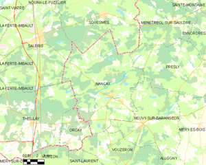
Nançay
- commune in Cher, France
- Country:
- Postal Code: 18330
- Coordinates: 47° 21' 0" N, 2° 11' 40" E
- GPS tracks (wikiloc): [Link]
- Area: 106.33 sq km
- Population: 874
- Web site: [Link]

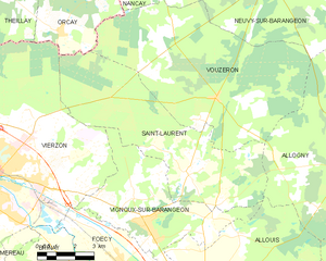
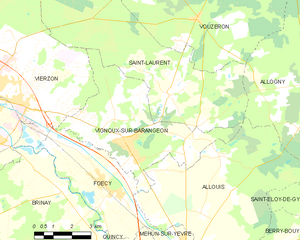
Saint-Laurent
- commune in Cher, France
- Country:
- Postal Code: 18330
- Coordinates: 47° 13' 30" N, 2° 12' 7" E
- GPS tracks (wikiloc): [Link]
- AboveSeaLevel: 115 м m
- Area: 38.72 sq km
- Population: 494
- Web site: [Link]

Massay
- commune in Cher, France
- Country:
- Postal Code: 18120
- Coordinates: 47° 9' 14" N, 1° 59' 34" E
- GPS tracks (wikiloc): [Link]
- Area: 47.94 sq km
- Population: 1404