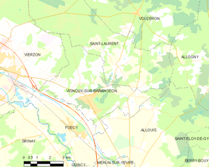
Saint-Laurent (Saint-Laurent)

- commune in Cher, France
- Country:

- Postal Code: 18330
- Coordinates: 47° 13' 30" N, 2° 12' 7" E


- GPS tracks (wikiloc): [Link]
- AboveSeaLevel: 115 м m
- Area: 38.72 sq km
- Population: 494
- Web site: http://www.saintlaurent18.net/
- Wikipedia en: wiki(en)
- Wikipedia: wiki(fr)
- Wikidata storage: Wikidata: Q738202
- Wikipedia Commons Category: [Link]
- Freebase ID: [/m/03md2s0]
- GeoNames ID: Alt: [6616040]
- SIREN number: [211802194]
- BnF ID: [152495655]
- INSEE municipality code: 18219
Shares border with regions:
Allogny
- commune in Cher, France
- Country:
- Postal Code: 18110
- Coordinates: 47° 13' 34" N, 2° 19' 23" E
- GPS tracks (wikiloc): [Link]
- Area: 49.53 sq km
- Population: 1010
- Web site: [Link]


Vouzeron
- commune in Cher, France
- Country:
- Postal Code: 18330
- Coordinates: 47° 15' 37" N, 2° 13' 19" E
- GPS tracks (wikiloc): [Link]
- Area: 52.63 sq km
- Population: 553
- Web site: [Link]

Vignoux-sur-Barangeon
- commune in Cher, France
- Country:
- Postal Code: 18500
- Coordinates: 47° 12' 6" N, 2° 10' 18" E
- GPS tracks (wikiloc): [Link]
- Area: 24.87 sq km
- Population: 2141
- Web site: [Link]
Orçay
- commune in Loir-et-Cher, France
- Country:
- Postal Code: 41300
- Coordinates: 47° 17' 26" N, 2° 6' 39" E
- GPS tracks (wikiloc): [Link]
- Area: 18.75 sq km
- Population: 245


Allouis
- commune in Cher, France
- Country:
- Postal Code: 18500
- Coordinates: 47° 9' 57" N, 2° 13' 37" E
- GPS tracks (wikiloc): [Link]
- Area: 35.59 sq km
- Population: 1050


Vierzon
- commune in Cher, France
- Country:
- Postal Code: 18100
- Coordinates: 47° 13' 19" N, 2° 4' 6" E
- GPS tracks (wikiloc): [Link]
- Area: 74.5 sq km
- Population: 26919
- Web site: [Link]