Vierzon (Vierzon)

- commune in Cher, France
- Country:

- Postal Code: 18100
- Coordinates: 47° 13' 19" N, 2° 4' 6" E


- GPS tracks (wikiloc): [Link]
- Area: 74.5 sq km
- Population: 26919
- Web site: http://www.ville-vierzon.fr
- Wikipedia en: wiki(en)
- Wikipedia: wiki(fr)
- Wikidata storage: Wikidata: Q208538
- Wikipedia Commons Category: [Link]
- Freebase ID: [/m/075n7c]
- Freebase ID: [/m/075n7c]
- GeoNames ID: Alt: [2969257]
- GeoNames ID: Alt: [2969257]
- SIREN number: [211802798]
- SIREN number: [211802798]
- BnF ID: [152496256]
- BnF ID: [152496256]
- VIAF ID: Alt: [168443197]
- VIAF ID: Alt: [168443197]
- GND ID: Alt: [4119426-3]
- GND ID: Alt: [4119426-3]
- archINFORM location ID: [5843]
- archINFORM location ID: [5843]
- Library of Congress authority ID: Alt: [n81071949]
- Library of Congress authority ID: Alt: [n81071949]
- MusicBrainz area ID: [ac2e5191-1142-4577-8d14-bd36b4dc8778]
- MusicBrainz area ID: [ac2e5191-1142-4577-8d14-bd36b4dc8778]
- WOEID: [631219]
- WOEID: [631219]
- Encyclopædia Britannica Online ID: [place/Vierzon]
- Encyclopædia Britannica Online ID: [place/Vierzon]
- Gran Enciclopèdia Catalana ID: [0070526]
- Gran Enciclopèdia Catalana ID: [0070526]
- Facebook Places ID: [108156812540001]
- Facebook Places ID: [108156812540001]
- INSEE municipality code: 18279
- INSEE municipality code: 18279
Shares border with regions:


Theillay
- commune in Loir-et-Cher, France
- Country:
- Postal Code: 41300
- Coordinates: 47° 18' 50" N, 2° 2' 25" E
- GPS tracks (wikiloc): [Link]
- Area: 96.38 sq km
- Population: 1308

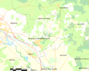
Vignoux-sur-Barangeon
- commune in Cher, France
- Country:
- Postal Code: 18500
- Coordinates: 47° 12' 6" N, 2° 10' 18" E
- GPS tracks (wikiloc): [Link]
- Area: 24.87 sq km
- Population: 2141
- Web site: [Link]
Méry-sur-Cher
- commune in Cher, France
- Country:
- Postal Code: 18100
- Coordinates: 47° 14' 46" N, 1° 59' 18" E
- GPS tracks (wikiloc): [Link]
- Area: 20.91 sq km
- Population: 665


Méreau
- commune in Cher, France
- Country:
- Postal Code: 18120
- Coordinates: 47° 9' 48" N, 2° 3' 3" E
- GPS tracks (wikiloc): [Link]
- Area: 18.65 sq km
- Population: 2627


Brinay
- commune in Cher, France
- Country:
- Postal Code: 18120
- Coordinates: 47° 10' 39" N, 2° 7' 40" E
- GPS tracks (wikiloc): [Link]
- Area: 29.48 sq km
- Population: 530


Foëcy
- commune in Cher, France
- Country:
- Postal Code: 18500
- Coordinates: 47° 10' 37" N, 2° 9' 42" E
- GPS tracks (wikiloc): [Link]
- Area: 16.21 sq km
- Population: 2079
Saint-Hilaire-de-Court
- commune in Cher, France
- Country:
- Postal Code: 18100
- Coordinates: 47° 12' 24" N, 2° 1' 21" E
- GPS tracks (wikiloc): [Link]
- Area: 11.75 sq km
- Population: 613
Orçay
- commune in Loir-et-Cher, France
- Country:
- Postal Code: 41300
- Coordinates: 47° 17' 26" N, 2° 6' 39" E
- GPS tracks (wikiloc): [Link]
- Area: 18.75 sq km
- Population: 245

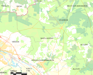
Saint-Laurent
- commune in Cher, France
- Country:
- Postal Code: 18330
- Coordinates: 47° 13' 30" N, 2° 12' 7" E
- GPS tracks (wikiloc): [Link]
- AboveSeaLevel: 115 м m
- Area: 38.72 sq km
- Population: 494
- Web site: [Link]