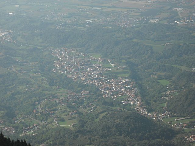
Cappella Maggiore (Cappella Maggiore)
.svg)
- Italian comune
 Hiking in Cappella Maggiore
Cappella Maggiore, located in the Veneto region of Italy, offers a picturesque setting for hiking enthusiasts. The area is characterized by its stunning natural landscapes, including rolling hills, forests, and scenic viewpoints. Here are some tips and highlights for hiking in Cappella Maggiore:
Trails:
-
Local Hiking Trails: There are several marked hiking trails around Cappella Maggiore that cater to different skill levels. You can find well-maintained paths that lead through beautiful countryside, vineyards, and forests.
-
Natural Park Trails: Consider exploring trails in nearby natural parks, like the Parco Nazionale delle Dolomiti Bellunesi, which feature diverse terrain and breathtaking views of the Dolomites.
Highlights:
-
Panoramic Views: Many trails offer stunning views of the surrounding mountains and valleys, especially during sunrise and sunset. Don't forget your camera to capture the scenery!
-
Cultural Points: Along the trails, you may encounter historical sites, including old churches and rural farmhouses, which showcase the local architecture and culture.
Hiking Tips:
-
Season: Spring and autumn are ideal for hiking in this region due to mild temperatures. Summer can get hot, while winter hiking may require additional gear.
-
Gear: Wear sturdy hiking boots and dress in layers, as the weather can change quickly. A good backpack with water, snacks, and a first aid kit is essential.
-
Maps and Guides: Utilize local maps and guide services to help navigate the trails and ensure safety.
Accessibility:
Cappella Maggiore is accessible from major cities in the Veneto region like Treviso and Belluno, making it a convenient destination for a day hike or weekend getaway.
Conclusion:
Hiking in Cappella Maggiore offers a blend of natural beauty and cultural experiences. Whether you're an experienced hiker or a beginner, the trails in this region can provide a memorable outdoor adventure. Be sure to respect nature and enjoy the serene atmosphere of this beautiful part of Italy!
- Country:

- Postal Code: 31012
- Local Dialing Code: 0438
- Licence Plate Code: TV
- Coordinates: 45° 58' 0" N, 12° 22' 0" E


- GPS tracks (wikiloc): [Link]
- AboveSeaLevel: 115 м m
- Area: 11.09 sq km
- Population: 4692
- Web site: http://www.cappellamaggiore.net/
- Wikipedia en: wiki(en)
- Wikipedia: wiki(it)
- Wikidata storage: Wikidata: Q29363
- Wikipedia Commons Category: [Link]
- Freebase ID: [/m/0f95xc]
- GeoNames ID: Alt: [6541820]
- VIAF ID: Alt: [144239363]
- OSM relation ID: [46612]
- TGN ID: [7044010]
- UN/LOCODE: [ITCMK]
- ISTAT ID: 026007
- Italian cadastre code: B678
Shares border with regions:


Colle Umberto
- Italian comune
Hiking in Colle Umberto
Colle Umberto, a picturesque location in the province of Treviso in northeastern Italy, offers a delightful hiking experience amidst beautiful landscapes, ancient trails, and charming villages. Though it's not as renowned as some of Italy’s larger national parks, it is part of the broader region of the Veneto, characterized by rolling hills, vineyards, and olive groves....
- Country:
- Postal Code: 31014
- Local Dialing Code: 0438
- Licence Plate Code: TV
- Coordinates: 45° 57' 0" N, 12° 21' 0" E
- GPS tracks (wikiloc): [Link]
- AboveSeaLevel: 144 м m
- Area: 13.58 sq km
- Population: 5093
- Web site: [Link]

Fregona
- Italian comune
Hiking in Fregona
Fregona, a charming village located in the Treviso region of Italy, offers several opportunities for hikers and outdoor enthusiasts. Nestled within the foothills of the Prealps, it's surrounded by beautiful landscapes, scenic trails, and historical sites....
- Country:
- Postal Code: 31010
- Local Dialing Code: 0438
- Licence Plate Code: TV
- Coordinates: 46° 0' 29" N, 12° 20' 19" E
- GPS tracks (wikiloc): [Link]
- AboveSeaLevel: 251 м m
- Area: 42.72 sq km
- Population: 2970
- Web site: [Link]


Sarmede
- Italian comune
Hiking in Sarmede
Sarmede, a charming village located in the province of Treviso in the Veneto region of Italy, offers some wonderful opportunities for hiking. Surrounded by the picturesque landscapes of the Valdobbiadene hills and the nearby Prealps, Sarmede is an ideal spot for nature lovers and hikers of all skill levels....
- Country:
- Postal Code: 31026
- Local Dialing Code: 0438
- Licence Plate Code: TV
- Coordinates: 45° 58' 39" N, 12° 23' 7" E
- GPS tracks (wikiloc): [Link]
- AboveSeaLevel: 103 м m
- Area: 18.01 sq km
- Population: 3061
- Web site: [Link]


Cordignano
- Italian comune
Hiking in Cordignano
Cordignano is a small municipality located in the province of Treviso, in the Veneto region of Italy. It is known for its picturesque landscapes, rolling hills, and a variety of outdoor activities, making it a great spot for hiking enthusiasts....
- Country:
- Postal Code: 31016
- Local Dialing Code: 0438
- Licence Plate Code: TV
- Coordinates: 45° 57' 0" N, 12° 25' 0" E
- GPS tracks (wikiloc): [Link]
- AboveSeaLevel: 56 м m
- Area: 26.25 sq km
- Population: 7024
- Web site: [Link]


Vittorio Veneto
- Italian comune
Hiking in Vittorio Veneto
Vittorio Veneto, located in the Veneto region of Italy, is surrounded by stunning natural landscapes, making it a fantastic destination for hiking enthusiasts. Here are some key aspects of hiking in this area:...
- Country:
- Postal Code: 31029
- Local Dialing Code: 0438
- Licence Plate Code: TV
- Coordinates: 45° 59' 0" N, 12° 18' 0" E
- GPS tracks (wikiloc): [Link]
- AboveSeaLevel: 138 м m
- Area: 82.8 sq km
- Population: 28389
- Web site: [Link]