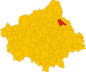
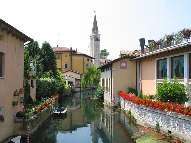
Cordignano (Cordignano)
.svg)
- Italian comune
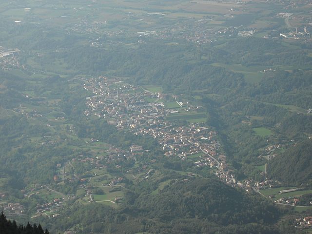
 Hiking in Cordignano
Cordignano is a small municipality located in the province of Treviso, in the Veneto region of Italy. It is known for its picturesque landscapes, rolling hills, and a variety of outdoor activities, making it a great spot for hiking enthusiasts.
Hiking Opportunities:
-
Scenic Trails: The area around Cordignano features a network of trails that offer stunning views of the surrounding countryside, vineyards, and historical sites. You can find routes tailored to different skill levels, ensuring everyone can enjoy the natural beauty.
-
Parco Naturale Regionale dei Colli Euganei: A bit further from Cordignano, this regional park provides numerous trails through diverse landscapes, from forested areas to rocky outcrops. It’s a popular destination for those looking to experience more rugged terrain.
-
Cultural and Historical Sites: While hiking, you can explore charming villages, ancient churches, and historical landmarks. It's a great opportunity to combine physical activity with cultural experiences.
Best Times to Hike:
- Spring (March to June): This is one of the best times to hike in Cordignano, as the weather is pleasant, and wildflowers bloom.
- Fall (September to November): The autumn foliage adds beautiful colors to the landscape, and the temperatures are generally mild.
Preparation Tips:
- Footwear: Wear appropriate hiking boots or shoes with good traction, as some trails can be uneven or slippery.
- Gear: Bring a daypack with water, snacks, a first-aid kit, and weather-appropriate clothing.
- Navigation: Familiarize yourself with trail maps and consider downloading GPS routes to ensure you stay on track.
Local Recommendations:
- Guided Tours: If you're new to the area, consider joining a guided hiking tour for local insights and safety.
- Taste Local Cuisine: After a hike, enjoy local dishes at nearby restaurants or trattorias that often feature regional specialties.
Whether you’re looking for a leisurely stroll or a more challenging hike, Cordignano offers a wonderful outdoor experience for all levels of hiking enthusiasts. Enjoy your adventure!
- Country:

- Postal Code: 31016
- Local Dialing Code: 0438
- Licence Plate Code: TV
- Coordinates: 45° 57' 0" N, 12° 25' 0" E


- GPS tracks (wikiloc): [Link]
- AboveSeaLevel: 56 м m
- Area: 26.25 sq km
- Population: 7024
- Web site: http://www.comune.cordignano.tv.it
- Wikipedia en: wiki(en)
- Wikipedia: wiki(it)
- Wikidata storage: Wikidata: Q47105
- Wikipedia Commons Category: [Link]
- Freebase ID: [/m/0dzq1s]
- GeoNames ID: Alt: [6536642]
- VIAF ID: Alt: [131521280]
- OSM relation ID: [46517]
- MusicBrainz area ID: [ff59ecf6-17f9-4aed-8c02-58bb19069ba4]
- UN/LOCODE: [ITODN]
- ISTAT ID: 026022
- Italian cadastre code: C992
Shares border with regions:


Cappella Maggiore
- Italian comune
Hiking in Cappella Maggiore
Cappella Maggiore, located in the Veneto region of Italy, offers a picturesque setting for hiking enthusiasts. The area is characterized by its stunning natural landscapes, including rolling hills, forests, and scenic viewpoints. Here are some tips and highlights for hiking in Cappella Maggiore:...
- Country:
- Postal Code: 31012
- Local Dialing Code: 0438
- Licence Plate Code: TV
- Coordinates: 45° 58' 0" N, 12° 22' 0" E
- GPS tracks (wikiloc): [Link]
- AboveSeaLevel: 115 м m
- Area: 11.09 sq km
- Population: 4692
- Web site: [Link]

Godega di Sant'Urbano
- Italian comune
Hiking in Godega di Sant'Urbano
Godega di Sant'Urbano, located in the Veneto region of Italy, is a charming area that offers a range of outdoor activities, including hiking. While it's primarily known for its agricultural landscapes and proximity to the scenic foothills of the Alps, it also provides opportunities for those looking to explore nature on foot....
- Country:
- Postal Code: 31010
- Local Dialing Code: 0438
- Licence Plate Code: TV
- Coordinates: 45° 55' 43" N, 12° 23' 49" E
- GPS tracks (wikiloc): [Link]
- AboveSeaLevel: 52 м m
- Area: 24.34 sq km
- Population: 6034
- Web site: [Link]


Orsago
- Italian comune
Hiking in Orsago
Orsago, located in the beautiful region of Veneto, Italy, offers a variety of hiking opportunities amidst stunning natural landscapes, vineyards, and charming rural scenery. While not as widely known as some other hiking destinations in Italy, Orsago and its vicinity can provide a peaceful escape for outdoor enthusiasts....
- Country:
- Postal Code: 31010
- Local Dialing Code: 0438
- Licence Plate Code: TV
- Coordinates: 45° 56' 0" N, 12° 25' 0" E
- GPS tracks (wikiloc): [Link]
- AboveSeaLevel: 40 м m
- Area: 10.71 sq km
- Population: 3877
- Web site: [Link]


Colle Umberto
- Italian comune
Hiking in Colle Umberto
Colle Umberto, a picturesque location in the province of Treviso in northeastern Italy, offers a delightful hiking experience amidst beautiful landscapes, ancient trails, and charming villages. Though it's not as renowned as some of Italy’s larger national parks, it is part of the broader region of the Veneto, characterized by rolling hills, vineyards, and olive groves....
- Country:
- Postal Code: 31014
- Local Dialing Code: 0438
- Licence Plate Code: TV
- Coordinates: 45° 57' 0" N, 12° 21' 0" E
- GPS tracks (wikiloc): [Link]
- AboveSeaLevel: 144 м m
- Area: 13.58 sq km
- Population: 5093
- Web site: [Link]

Fregona
- Italian comune
Hiking in Fregona
Fregona, a charming village located in the Treviso region of Italy, offers several opportunities for hikers and outdoor enthusiasts. Nestled within the foothills of the Prealps, it's surrounded by beautiful landscapes, scenic trails, and historical sites....
- Country:
- Postal Code: 31010
- Local Dialing Code: 0438
- Licence Plate Code: TV
- Coordinates: 46° 0' 29" N, 12° 20' 19" E
- GPS tracks (wikiloc): [Link]
- AboveSeaLevel: 251 м m
- Area: 42.72 sq km
- Population: 2970
- Web site: [Link]


Sarmede
- Italian comune
Hiking in Sarmede
Sarmede, a charming village located in the province of Treviso in the Veneto region of Italy, offers some wonderful opportunities for hiking. Surrounded by the picturesque landscapes of the Valdobbiadene hills and the nearby Prealps, Sarmede is an ideal spot for nature lovers and hikers of all skill levels....
- Country:
- Postal Code: 31026
- Local Dialing Code: 0438
- Licence Plate Code: TV
- Coordinates: 45° 58' 39" N, 12° 23' 7" E
- GPS tracks (wikiloc): [Link]
- AboveSeaLevel: 103 м m
- Area: 18.01 sq km
- Population: 3061
- Web site: [Link]


Gaiarine
- Italian comune
Hiking in Gaiarine
Gaiarine, located in the province of Treviso in the Veneto region of Italy, is not as widely recognized for hiking as some of the more famous destinations in the Alps or Dolomites, but it can still offer some pleasant outdoor experiences....
- Country:
- Postal Code: 31018
- Local Dialing Code: 0434
- Licence Plate Code: TV
- Coordinates: 45° 53' 0" N, 12° 29' 0" E
- GPS tracks (wikiloc): [Link]
- AboveSeaLevel: 20 м m
- Area: 28.78 sq km
- Population: 6070
- Web site: [Link]
Caneva
- Italian comune
Hiking in Caneva
Caneva is a charming town located in the Province of Treviso in northern Italy, not far from the picturesque landscape of the Friuli Venezia Giulia region. The area is known for its beautiful countryside, vineyards, and proximity to the foothills of the Alps. While Caneva itself may not be as famous for hiking as some other locations, there are still several hiking opportunities in and around this region....
- Country:
- Postal Code: 33070
- Local Dialing Code: 0434
- Licence Plate Code: PN
- Coordinates: 45° 58' 0" N, 12° 27' 0" E
- GPS tracks (wikiloc): [Link]
- AboveSeaLevel: 57 м m
- Area: 41.79 sq km
- Population: 6339
- Web site: [Link]
Sacile
- Italian comune
Hiking in Sacile
Sacile, located in the Friuli Venezia Giulia region of northern Italy, is a charming town surrounded by beautiful landscapes, making it a great destination for hiking enthusiasts. The area features lush hills, rivers, and stunning views of the surrounding mountains, including the nearby Dolomites. Here are some key points to consider when planning a hiking trip in Sacile:...
- Country:
- Postal Code: 33077
- Local Dialing Code: 0434
- Licence Plate Code: PN
- Coordinates: 45° 57' 15" N, 12° 30' 10" E
- GPS tracks (wikiloc): [Link]
- AboveSeaLevel: 25 м m
- Area: 32.74 sq km
- Population: 19905
- Web site: [Link]