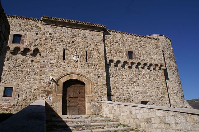
Castelbottaccio (Castelbottaccio)
.svg)
- Italian comune
 Hiking in Castelbottaccio
Castelbottaccio is a charming village located in the Molise region of Italy. It offers a unique hiking experience for those looking to explore the natural beauty and cultural heritage of the area. Here are some highlights and tips for hiking in and around Castelbottaccio:
Trails and Nature:
-
Scenic Views: The area surrounding Castelbottaccio boasts panoramic views of the surrounding hills and valleys, with lush greenery and rustic landscapes typical of rural Italy. Look for viewpoints that offer stunning vistas, especially at sunrise or sunset.
-
Local Flora and Fauna: The region is rich in biodiversity. Keep an eye out for local wildlife, including various bird species and small mammals, as well as beautiful wildflowers depending on the season.
-
Historical Trails: Some trails may lead to ancient ruins or historical sites, allowing hikers to combine nature walks with cultural exploration. Look out for signs that indicate historical points of interest.
Popular Hiking Routes:
-
Cerro di Castelbottaccio: A hike up to Cerro can be invigorating, with well-marked paths offering access to the summit. The view from the top rewards your effort with a breathtaking panorama of the surrounding countryside.
-
Valle dei Mulini: A scenic trail that may take you through valleys dotted with old mills and historic structures, providing a glimpse into the region's past and its rural heritage.
Preparation:
-
Seasonal Considerations: The best time to hike in this region is during spring (April to June) and fall (September to October) when the weather is mild and the trails are in good condition. Summer can be hot, and winter may bring snow, so check conditions before heading out.
-
Gear: Make sure to wear proper hiking shoes, bring water, and have snacks on hand. A good map or GPS device can help you navigate the trails, especially if they are less traveled.
-
Local Regulations and Safety: Always adhere to local guidelines regarding trail usage and conservation efforts. Inform someone about your hiking plans, especially if venturing into remote areas.
Cultural Experience:
-
Local Cuisine: After a day of hiking, consider enjoying the local cuisine. Castelbottaccio offers traditional Molise dishes that highlight local ingredients. It's a great way to unwind after your hike!
-
Community Connection: Engage with locals, as they can provide insights into hidden trails and local history, enhancing your hiking experience.
By combining the natural beauty of the landscape, historical elements, and the richness of local culture, hiking in Castelbottaccio can be a memorable adventure. Make sure to plan adequately and enjoy the breathtaking scenery and tranquility that the Molise region has to offer!
- Country:

- Postal Code: 86030
- Local Dialing Code: 0874
- Licence Plate Code: CB
- Coordinates: 41° 45' 0" N, 14° 42' 0" E


- GPS tracks (wikiloc): [Link]
- AboveSeaLevel: 618 м m
- Area: 11.22 sq km
- Population: 274
- Web site: http://www.comunecastelbottaccio.it/Home.aspx
- Wikipedia en: wiki(en)
- Wikipedia: wiki(it)
- Wikidata storage: Wikidata: Q277437
- Wikipedia Commons Category: [Link]
- Freebase ID: [/m/0gnnpt]
- GeoNames ID: Alt: [6538901]
- OSM relation ID: [41520]
- WOEID: [713283]
- ISTAT ID: 070013
- Italian cadastre code: C066
Shares border with regions:


Lupara, Molise
- Italian comune
Hiking in Lupara, Molise
Hiking in the region of Molise, particularly in and around Lupara, offers a unique experience for outdoor enthusiasts. Molise is often less crowded than other Italian regions, providing a more tranquil and pristine natural environment....
- Country:
- Postal Code: 86030
- Local Dialing Code: 0874
- Licence Plate Code: CB
- Coordinates: 41° 46' 0" N, 14° 44' 0" E
- GPS tracks (wikiloc): [Link]
- AboveSeaLevel: 505 м m
- Area: 25.87 sq km
- Population: 483
- Web site: [Link]
Lucito
- Italian comune
Hiking in Lucito
Lucito is a small town located in the Molise region of Italy. While it may not be as well-known for hiking as other Italian destinations, the surrounding landscapes offer beautiful opportunities for outdoor activities, including hiking....
- Country:
- Postal Code: 86030
- Local Dialing Code: 0874
- Licence Plate Code: CB
- Coordinates: 41° 44' 0" N, 14° 41' 0" E
- GPS tracks (wikiloc): [Link]
- AboveSeaLevel: 480 м m
- Area: 31.56 sq km
- Population: 666
- Web site: [Link]

Civitacampomarano
- Italian comune
Hiking in Civitacampomarano
Civitacampomarano is a charming village located in the Molise region of Italy, known for its stunning landscapes, rich history, and traditional architecture. Hiking in and around Civitacampomarano provides a unique opportunity to explore the natural beauty and cultural heritage of this lesser-known area of Italy....
- Country:
- Postal Code: 86030
- Local Dialing Code: 0874
- Licence Plate Code: CB
- Coordinates: 41° 47' 0" N, 14° 41' 0" E
- GPS tracks (wikiloc): [Link]
- AboveSeaLevel: 520 м m
- Area: 38.89 sq km
- Population: 385
- Web site: [Link]
Morrone del Sannio
- Italian comune
Hiking in Morrone del Sannio
Morrone del Sannio is a picturesque area located in the Molise region of Italy, known for its stunning landscapes and rich natural beauty. It offers a variety of hiking opportunities that cater to different skill levels, from leisurely walks to challenging trails. Here are some highlights of hiking in Morrone del Sannio:...
- Country:
- Postal Code: 86040
- Local Dialing Code: 0874
- Licence Plate Code: CB
- Coordinates: 41° 42' 41" N, 14° 46' 46" E
- GPS tracks (wikiloc): [Link]
- AboveSeaLevel: 827 м m
- Area: 45.84 sq km
- Population: 576
- Web site: [Link]