Castelforte (Castelforte)
.svg)
- Italian comune
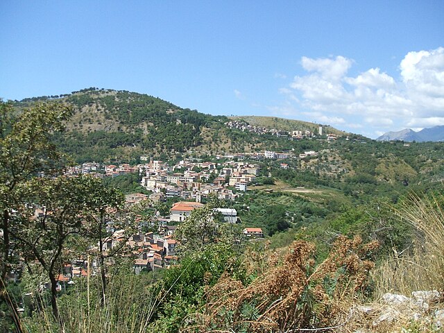
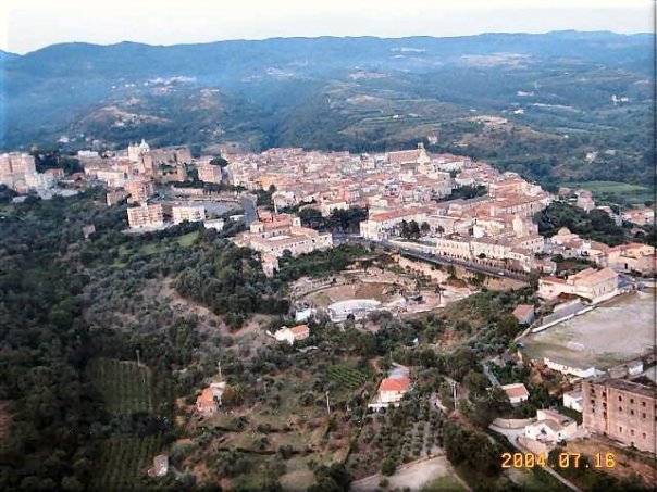
 Hiking in Castelforte
Castelforte, located in the region of Lazio, Italy, is a quaint town that offers various outdoor activities, including hiking. The surrounding areas are characterized by beautiful landscapes, rolling hills, and natural beauty, making it an appealing destination for outdoor enthusiasts.
Hiking Opportunities:
-
Natural Parks and Reserves:
- Explore nearby parks such as the Regional Park of Monte Aurunco which offers trails with diverse ecosystems, lush forests, and scenic views.
- Some trails may lead to breathtaking viewpoints overlooking valleys and mountains.
-
Local Trails:
- The area around Castelforte features several local trails that vary in difficulty. Some are suitable for beginners, while others are more challenging for experienced hikers.
- The trails often pass through olive groves and vineyards, providing a glimpse into local agriculture.
-
Historical Paths:
- Hiking in this region may also include historical paths that connect to the rich history of the area. Discover ancient ruins, traditional stone villages, and charming churches along your hike.
-
Guided Tours:
- Consider joining guided hiking tours offered by local operators. They can provide insights about the area’s flora, fauna, and history, making your experience richer.
Tips for Hiking in Castelforte:
- Check Weather Conditions: Weather can change rapidly, especially in mountainous areas. Always check the forecast before heading out.
- Pack Essentials: Bring plenty of water, snacks, a map or a GPS device, and wear suitable hiking shoes.
- Time Your Hikes: Start early in the day to avoid afternoon heat and take advantage of cooler temperatures.
- Respect Nature: Keep the trails clean and follow local regulations. Leave no trace to preserve the environment for future hikers.
Nearby Attractions:
- Cascate di Monte Gelato: This waterfall nearby is a beautiful spot that can be reached via a short hike. It's perfect for a picnic and enjoying nature.
- Terracina and Sperlonga: If you extend your trip, these coastal towns are close by and offer stunning beaches and additional hiking options along the coast.
Overall, hiking in Castelforte can be a rewarding experience with its mix of natural beauty, cultural heritage, and the tranquility of the Italian countryside. Whether you're a seasoned hiker or a beginner, there's something for everyone to enjoy.
- Country:

- Postal Code: 04021
- Local Dialing Code: 0771
- Licence Plate Code: LT
- Coordinates: 41° 18' 0" N, 13° 50' 0" E


- GPS tracks (wikiloc): [Link]
- AboveSeaLevel: 130 м m
- Area: 29.71 sq km
- Population: 4221
- Web site: http://www.comune.castelforte.lt.it
- Wikipedia en: wiki(en)
- Wikipedia: wiki(it)
- Wikidata storage: Wikidata: Q128062
- Wikipedia Commons Gallery: [Link]
- Wikipedia Commons Category: [Link]
- Freebase ID: [/m/0f8p69]
- GeoNames ID: Alt: [6538693]
- VIAF ID: Alt: [240129459]
- OSM relation ID: [41229]
- GND ID: Alt: [7604267-4]
- ISTAT ID: 059004
- Italian cadastre code: C104
Shares border with regions:
Coreno Ausonio
- Italian comune
Hiking in Coreno Ausonio
Coreno Ausonio is a picturesque village located in the province of Frosinone, in the Lazio region of Italy. Surrounded by the beautiful landscapes of the Aurunci Mountains and the scenic rolling hills of the Ciociaria area, it offers some excellent opportunities for hiking and enjoying nature....
- Country:
- Postal Code: 03040
- Local Dialing Code: 0776
- Licence Plate Code: FR
- Coordinates: 41° 20' 35" N, 13° 46' 36" E
- GPS tracks (wikiloc): [Link]
- AboveSeaLevel: 318 м m
- Area: 26.38 sq km
- Population: 1613
- Web site: [Link]
Sant'Andrea del Garigliano
- Italian comune
Hiking in Sant'Andrea del Garigliano
Sant'Andrea del Garigliano, a small municipality in the province of Frosinone, Italy, offers a unique blend of nature and culture for hikers. Nestled in the Italian countryside, it's characterized by lush landscapes, rolling hills, and scenic views of the surrounding areas....
- Country:
- Postal Code: 03040
- Local Dialing Code: 0776
- Licence Plate Code: FR
- Coordinates: 41° 22' 5" N, 13° 50' 30" E
- GPS tracks (wikiloc): [Link]
- AboveSeaLevel: 176 м m
- Area: 17.11 sq km
- Population: 1454
- Web site: [Link]


Vallemaio
- Italian comune
Hiking in Vallemaio
Vallemaio, located in the province of Frosinone in Italy, is a charming destination for outdoor enthusiasts, particularly hikers. The area is known for its beautiful landscapes, rolling hills, and rich natural environment, which offers a variety of trails suited to different skill levels....
- Country:
- Postal Code: 03040
- Local Dialing Code: 0776
- Licence Plate Code: FR
- Coordinates: 41° 22' 0" N, 13° 49' 0" E
- GPS tracks (wikiloc): [Link]
- AboveSeaLevel: 337 м m
- Area: 18.54 sq km
- Population: 934
- Web site: [Link]

Santi Cosma e Damiano, Lazio
- Italian comune
Hiking in Santi Cosma e Damiano, Lazio
Santi Cosma e Damiano is a charming village located in the province of Latina in the Lazio region of Italy. It's surrounded by beautiful landscapes, rich history, and a variety of trails that can cater to different skill levels – making it a nice destination for hikers....
- Country:
- Postal Code: 04020
- Local Dialing Code: 0771
- Licence Plate Code: LT
- Coordinates: 41° 18' 0" N, 13° 49' 0" E
- GPS tracks (wikiloc): [Link]
- AboveSeaLevel: 181 м m
- Area: 31.61 sq km
- Population: 6972
- Web site: [Link]
Rocca d'Evandro
- Italian comune
Hiking in Rocca d'Evandro
Rocca d'Evandro is a picturesque town located in the province of Caserta in southern Italy. Nestled in the foothills of the Matese Mountains, it offers a range of hiking opportunities for both novice and experienced hikers. Here are some key points to consider if you're planning to hike in this area:...
- Country:
- Postal Code: 81040
- Local Dialing Code: 0823
- Licence Plate Code: CE
- Coordinates: 41° 23' 0" N, 13° 53' 0" E
- GPS tracks (wikiloc): [Link]
- AboveSeaLevel: 83 м m
- Area: 49.54 sq km
- Population: 3178
- Web site: [Link]
Sessa Aurunca
- Italian comune
Hiking in Sessa Aurunca
Sessa Aurunca, located in the province of Caserta in Campania, Italy, is a beautiful destination for hiking enthusiasts. The region is characterized by its stunning landscapes, rich history, and diverse flora and fauna. Here’s a guide for hiking in Sessa Aurunca:...
- Country:
- Postal Code: 81037
- Local Dialing Code: 0823
- Licence Plate Code: CE
- Coordinates: 41° 14' 0" N, 13° 56' 0" E
- GPS tracks (wikiloc): [Link]
- AboveSeaLevel: 203 м m
- Area: 162.18 sq km
- Population: 21252
- Web site: [Link]