Santi Cosma e Damiano, Lazio (Santi Cosma e Damiano)
.svg)
- Italian comune
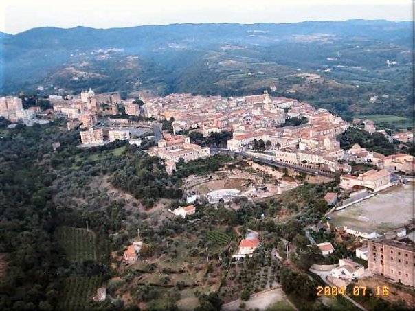
 Hiking in Santi Cosma e Damiano, Lazio
Santi Cosma e Damiano is a charming village located in the province of Latina in the Lazio region of Italy. It's surrounded by beautiful landscapes, rich history, and a variety of trails that can cater to different skill levels – making it a nice destination for hikers.
Hiking Opportunities
-
Monte Asprano: This mountain near Santi Cosma e Damiano offers well-marked trails leading to stunning panoramic views. You can enjoy a moderately challenging hike that typically takes around 2 to 4 hours, depending on your chosen path.
-
Cicero's Path (Sentiero di Cicerone): This long-distance trail runs through various regions of Italy, including areas around Santi Cosma e Damiano. Portions of this trail offer gorgeous views and the chance to explore nature and local flora and fauna.
-
Foresta di Ceraso: Just a short drive from the village, the Ceraso Forest provides a peaceful atmosphere with its ancient trees and rich wildlife. There are several easy to moderate trails perfect for families and less experienced hikers.
Tips for Hiking in the Area
-
Trail Preparation: Always check trail maps and information at the local tourist office. Make sure to choose the right trail according to your fitness level and the weather conditions.
-
Equipment: Wear comfortable, sturdy footwear and carry essentials such as water, snacks, a first aid kit, and a fully charged mobile phone.
-
Weather Considerations: The climate in Lazio can vary. While spring and fall are great for hiking due to mild temperatures, summer can be hot, and winter may bring snow in higher elevations.
-
Local Flora and Fauna: Be mindful of the local wildlife. Take note of the unique plant life and try to leave no trace during your hike to preserve the environment.
-
Cultural Elements: While hiking, consider exploring local historical sites, churches, and countryside scenery, which can enrich your hiking experience.
Conclusion
Santi Cosma e Damiano offers a great combination of nature and history, perfect for anyone looking to hike in a picturesque Italian setting. Whether you are after a challenging trek or a leisurely walk, the surrounding area has something to offer for every hiking enthusiast.
- Country:

- Postal Code: 04020
- Local Dialing Code: 0771
- Licence Plate Code: LT
- Coordinates: 41° 18' 0" N, 13° 49' 0" E


- GPS tracks (wikiloc): [Link]
- AboveSeaLevel: 181 м m
- Area: 31.61 sq km
- Population: 6972
- Web site: http://www.comune.santicosmaedamiano.lt.it/
- Wikipedia en: wiki(en)
- Wikipedia: wiki(it)
- Wikidata storage: Wikidata: Q128185
- Wikipedia Commons Gallery: [Link]
- Wikipedia Commons Category: [Link]
- Freebase ID: [/m/0f8pdp]
- GeoNames ID: Alt: [6541138]
- OSM relation ID: [41207]
- UN/LOCODE: [ITDAM]
- Digital Atlas of the Roman Empire ID: [29153]
- ISTAT ID: 059026
- Italian cadastre code: I339
Shares border with regions:
Coreno Ausonio
- Italian comune
Hiking in Coreno Ausonio
Coreno Ausonio is a picturesque village located in the province of Frosinone, in the Lazio region of Italy. Surrounded by the beautiful landscapes of the Aurunci Mountains and the scenic rolling hills of the Ciociaria area, it offers some excellent opportunities for hiking and enjoying nature....
- Country:
- Postal Code: 03040
- Local Dialing Code: 0776
- Licence Plate Code: FR
- Coordinates: 41° 20' 35" N, 13° 46' 36" E
- GPS tracks (wikiloc): [Link]
- AboveSeaLevel: 318 м m
- Area: 26.38 sq km
- Population: 1613
- Web site: [Link]


Castelforte
- Italian comune
Hiking in Castelforte
Castelforte, located in the region of Lazio, Italy, is a quaint town that offers various outdoor activities, including hiking. The surrounding areas are characterized by beautiful landscapes, rolling hills, and natural beauty, making it an appealing destination for outdoor enthusiasts....
- Country:
- Postal Code: 04021
- Local Dialing Code: 0771
- Licence Plate Code: LT
- Coordinates: 41° 18' 0" N, 13° 50' 0" E
- GPS tracks (wikiloc): [Link]
- AboveSeaLevel: 130 м m
- Area: 29.71 sq km
- Population: 4221
- Web site: [Link]


Minturno
- Italian comune
Hiking in Minturno
Minturno, located in the province of Latina, Italy, offers a unique combination of historical sites and beautiful natural scenery, making it a great destination for hiking enthusiasts. The region is characterized by the striking landscapes of the Aurunci Mountains, lush Mediterranean vegetation, and views of the Tyrrhenian Sea....
- Country:
- Postal Code: 04026 - 04028 (Scauri e Marina)
- Local Dialing Code: 0771
- Licence Plate Code: LT
- Coordinates: 41° 16' 0" N, 13° 45' 0" E
- GPS tracks (wikiloc): [Link]
- AboveSeaLevel: 141 м m
- Area: 42.14 sq km
- Population: 19804
- Web site: [Link]
Sessa Aurunca
- Italian comune
Hiking in Sessa Aurunca
Sessa Aurunca, located in the province of Caserta in Campania, Italy, is a beautiful destination for hiking enthusiasts. The region is characterized by its stunning landscapes, rich history, and diverse flora and fauna. Here’s a guide for hiking in Sessa Aurunca:...
- Country:
- Postal Code: 81037
- Local Dialing Code: 0823
- Licence Plate Code: CE
- Coordinates: 41° 14' 0" N, 13° 56' 0" E
- GPS tracks (wikiloc): [Link]
- AboveSeaLevel: 203 м m
- Area: 162.18 sq km
- Population: 21252
- Web site: [Link]