Cavriana (Cavriana)
- Italian comune
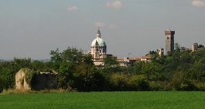
Cavriana is a charming town located in the Lombardy region of Italy, surrounded by beautiful landscapes that are perfect for hiking. The area is characterized by gentle hills, vineyards, and historic sites, making it an attractive destination for hikers of all levels.
Hiking Trails
-
Natural Parks: Cavriana is near the Parco del Mincio, which offers a variety of trails through lush vegetation, along rivers, and past lagoons. These trails range from easy walks to more challenging routes.
-
Regional Trails: The region offers several marked hiking paths that connect to surrounding towns and points of interest. You can explore trails that lead to local vineyards and olive groves, providing scenic views and potential for wine tasting stops.
Points of Interest
- Castello di Cavriana: The remains of this castle provide a historical backdrop for your hike, and the views from the top are stunning.
- Cultural Sites: Along the trails, you may encounter local churches and other historical landmarks that add cultural depth to your hiking experience.
- Scenic Views: The hills around Cavriana offer panoramic views of the surrounding countryside, particularly beautiful in the autumn when the foliage changes.
Tips for Hiking in Cavriana
- Seasonal Considerations: Spring and autumn are ideal times to hike, as the temperatures are mild and the scenery is vibrant. Summer can be hot, so plan for early morning or late afternoon hikes.
- Preparation: Bring plenty of water, wear appropriate footwear, and consider carrying a mapping app or guide to help navigate the trails.
- Local Guidance: If you're unsure where to start, consider reaching out to local hiking groups or tourist information centers for tips and trail maps.
Conclusion
Cavriana offers a unique hiking experience with its combination of natural beauty, historical significance, and local flavors. Whether you're seeking a peaceful walk in nature or a more challenging hike, this area has something to offer every hiking enthusiast.
- Country:

- Postal Code: 46040
- Local Dialing Code: 0376
- Licence Plate Code: MN
- Coordinates: 45° 21' 0" N, 10° 36' 0" E


- GPS tracks (wikiloc): [Link]
- AboveSeaLevel: 170 м m
- Area: 36.91 sq km
- Population: 3828
- Web site: http://www.comune.cavriana.mn.it/
- Wikipedia en: wiki(en)
- Wikipedia: wiki(it)
- Wikidata storage: Wikidata: Q42321
- Wikipedia Commons Category: [Link]
- Freebase ID: [/m/0gj_xz]
- GeoNames ID: Alt: [6539792]
- VIAF ID: Alt: [158915304]
- OSM relation ID: [44662]
- MusicBrainz area ID: [8188feca-2a04-4dd6-8ee8-b5d36f64858d]
- UN/LOCODE: [ITCV9]
- ISTAT ID: 020018
- Italian cadastre code: C406
Shares border with regions:


Lonato del Garda
- Italian comune
Lonato del Garda, located in the Lombardy region of northern Italy, is a beautiful area that offers various hiking opportunities, particularly due to its proximity to Lake Garda and the surrounding hills. Here are some key points to consider if you're planning a hiking trip in this region:...
- Country:

- Postal Code: 25017
- Local Dialing Code: 030
- Licence Plate Code: BS
- Coordinates: 45° 27' 39" N, 10° 28' 38" E


- GPS tracks (wikiloc): [Link]
- AboveSeaLevel: 170 м m
- Area: 68.2 sq km
- Population: 16506
- Web site: [Link]

Pozzolengo
- Italian comune
Pozzolengo is a charming village located in the Lombardy region of Italy, near Lake Garda. The surrounding area offers a variety of hiking opportunities, characterized by beautiful landscapes, vineyards, olive groves, and historic sites....
- Country:

- Postal Code: 25010
- Local Dialing Code: 030
- Licence Plate Code: BS
- Coordinates: 45° 24' 25" N, 10° 38' 2" E


- GPS tracks (wikiloc): [Link]
- AboveSeaLevel: 135 м m
- Area: 21.33 sq km
- Population: 3558
- Web site: [Link]


Monzambano
- Italian comune
Monzambano is a charming village located in the Lombardy region of Italy, near the southern shore of Lake Garda. The area is known for its beautiful landscapes, rolling hills, and historic sites, making it a good location for hiking and outdoor activities....
- Country:

- Postal Code: 46040
- Local Dialing Code: 0376
- Licence Plate Code: MN
- Coordinates: 45° 23' 0" N, 10° 42' 0" E


- GPS tracks (wikiloc): [Link]
- AboveSeaLevel: 88 м m
- Area: 30.02 sq km
- Population: 4877
- Web site: [Link]


Guidizzolo
- Italian comune
Guidizzolo is a small town located in the Lombardy region of Italy, near Mantua. While it might not be a well-known hiking destination like the Dolomites or Lake Como, there are still opportunities to explore the beautiful countryside around the area....
- Country:

- Postal Code: 46040
- Local Dialing Code: 0376
- Licence Plate Code: MN
- Coordinates: 45° 19' 0" N, 10° 35' 0" E


- GPS tracks (wikiloc): [Link]
- AboveSeaLevel: 46 м m
- Area: 22.38 sq km
- Population: 6013
- Web site: [Link]


Medole
- Italian comune
Medole is located in the Lombardy region of Italy, known for its picturesque landscapes and proximity to various outdoor activities, including hiking. While Medole itself may not be a major hiking destination, its surrounding area offers a variety of trails and natural settings that are great for hikers....
- Country:

- Postal Code: 46046
- Local Dialing Code: 0376
- Licence Plate Code: MN
- Coordinates: 45° 20' 0" N, 10° 31' 0" E


- GPS tracks (wikiloc): [Link]
- AboveSeaLevel: 62 м m
- Area: 25.73 sq km
- Population: 4055
- Web site: [Link]


Volta Mantovana
- Italian comune
Volta Mantovana, located in the Lombardy region of northern Italy, offers a variety of hiking opportunities. The area is characterized by scenic landscapes, historical sites, and a mix of gentle rolling hills and more challenging terrain. Here are some highlights for hiking in and around Volta Mantovana:...
- Country:

- Postal Code: 46049
- Local Dialing Code: 0376
- Licence Plate Code: MN
- Coordinates: 45° 19' 10" N, 10° 39' 34" E


- GPS tracks (wikiloc): [Link]
- AboveSeaLevel: 91 м m
- Area: 50.49 sq km
- Population: 7339
- Web site: [Link]


Solferino
- Italian comune
Hiking in Solferino, located in the Lombardy region of Italy, is a delightful experience characterized by scenic landscapes, historical significance, and a variety of trails that cater to different skill levels. Here are some key points about hiking in this area:...
- Country:

- Postal Code: 46040
- Local Dialing Code: 0376
- Licence Plate Code: MN
- Coordinates: 45° 22' 20" N, 10° 33' 59" E


- GPS tracks (wikiloc): [Link]
- AboveSeaLevel: 124 м m
- Area: 13.08 sq km
- Population: 2631
- Web site: [Link]

Goito
- Italian comune
Goito is a charming municipality located in the Lombardy region of northern Italy. While it is not as well-known for hiking as some of the more prominent regions in Italy (like the Dolomites or the Aosta Valley), there are still opportunities for outdoor enthusiasts to explore the natural beauty of the area....
- Country:

- Postal Code: 46044
- Local Dialing Code: 0376
- Licence Plate Code: MN
- Coordinates: 45° 15' 0" N, 10° 40' 0" E


- GPS tracks (wikiloc): [Link]
- AboveSeaLevel: 33 м m
- Area: 79.22 sq km
- Population: 10222
- Web site: [Link]

