
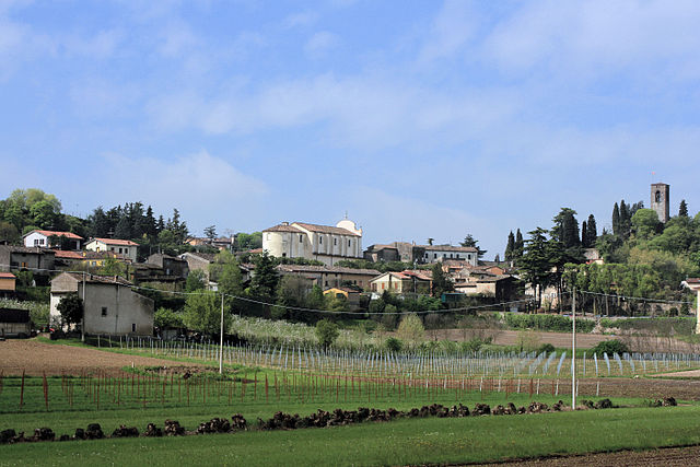
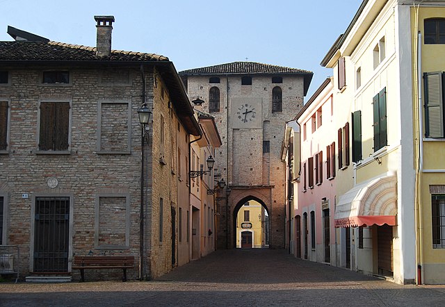
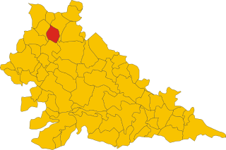
Goito (Goito)
.svg)
- Italian comune
 Hiking in Goito
Goito is a charming municipality located in the Lombardy region of northern Italy. While it is not as well-known for hiking as some of the more prominent regions in Italy (like the Dolomites or the Aosta Valley), there are still opportunities for outdoor enthusiasts to explore the natural beauty of the area.
Hiking in Goito
-
Scenic Routes: The countryside around Goito features a mix of vineyards, olive groves, and gentle hills, offering picturesque landscapes. Many local paths provide a chance to enjoy the serene environment and local flora and fauna.
-
Cicerone Trail: One popular hiking route is part of the Ciclabile del Mincio, a cycling trail that also accommodates hikers. This trail runs alongside the Mincio River, linking Goito to other towns and natural reserves in the region. It’s relatively flat and perfect for leisurely walks.
-
Nature Reserves: Nearby natural reserves, such as the Mincio Regional Park, offer well-marked trails through wetlands and riverine environments. Birdwatching and photography are popular here, given the diverse wildlife and beautiful scenery.
-
Historical Sites: Many hiking routes in the area may take you past historical landmarks, including old fortifications and churches, allowing you to combine history with your outdoor experience.
-
Accessibility: Since Goito is close to larger towns like Mantova (Mantua), you can easily access various hiking trails with just a short drive. This means you can base your hike around your interest, whether it’s nature or culture.
Tips for Hiking in Goito
- Maps and Guides: Always carry a detailed map or a hiking app on your phone to stay oriented. Local visitor centers can provide information on trails and conditions.
- Weather: Be mindful of the weather, as conditions can change. Spring and fall are particularly pleasant for hiking.
- Stay Hydrated: Bring plenty of water, especially during the warmer months, as some trails may not have easy access to refill.
Conclusion
While Goito might not have the dramatic mountain hikes found elsewhere in Italy, it provides a peaceful escape with the charm of the Italian countryside, making it suitable for day hikes, family outings, or casual strolls. Whether you’re interested in nature, history, or simply enjoying the outdoors, you'll find something to appreciate in the Goito area.
- Country:

- Postal Code: 46044
- Local Dialing Code: 0376
- Licence Plate Code: MN
- Coordinates: 45° 15' 0" N, 10° 40' 0" E


- GPS tracks (wikiloc): [Link]
- AboveSeaLevel: 33 м m
- Area: 79.22 sq km
- Population: 10222
- Web site: http://www.comune.goito.mn.it
- Wikipedia en: wiki(en)
- Wikipedia: wiki(it)
- Wikidata storage: Wikidata: Q42945
- Wikipedia Commons Category: [Link]
- Freebase ID: [/m/0bd4zz]
- GeoNames ID: Alt: [6537234]
- VIAF ID: Alt: [123140663]
- OSM relation ID: [44456]
- archINFORM location ID: [983]
- WOEID: [716253]
- Quora topic ID: [Goito]
- UN/LOCODE: [ITGOI]
- ISTAT ID: 020026
- Italian cadastre code: E078
Shares border with regions:
Porto Mantovano
- Italian comune
Hiking in Porto Mantovano
Hiking in Porto Mantovano offers a blend of natural beauty, cultural heritage, and picturesque landscapes. Located in the Lombardy region of Italy, near the city of Mantua, this area is characterized by its gentle hills, agricultural lands, and tranquil waterways....
- Country:
- Postal Code: 46047
- Local Dialing Code: 0376
- Licence Plate Code: MN
- Coordinates: 45° 11' 48" N, 10° 47' 38" E
- GPS tracks (wikiloc): [Link]
- AboveSeaLevel: 29 м m
- Area: 37.44 sq km
- Population: 16479
- Web site: [Link]

Cavriana
- Italian comune
Hiking in Cavriana
Cavriana is a charming town located in the Lombardy region of Italy, surrounded by beautiful landscapes that are perfect for hiking. The area is characterized by gentle hills, vineyards, and historic sites, making it an attractive destination for hikers of all levels....
- Country:
- Postal Code: 46040
- Local Dialing Code: 0376
- Licence Plate Code: MN
- Coordinates: 45° 21' 0" N, 10° 36' 0" E
- GPS tracks (wikiloc): [Link]
- AboveSeaLevel: 170 м m
- Area: 36.91 sq km
- Population: 3828
- Web site: [Link]


Rodigo
- Italian comune
Hiking in Rodigo
Rodigo is a small town in the Lombardy region of Italy, known for its historical architecture and charming countryside. While it's not a major hiking destination like the nearby Alps or National Parks, there are still opportunities for hiking and enjoying nature in the surrounding areas....
- Country:
- Postal Code: 46040
- Local Dialing Code: 0376
- Licence Plate Code: MN
- Coordinates: 45° 12' 0" N, 10° 38' 0" E
- GPS tracks (wikiloc): [Link]
- AboveSeaLevel: 31 м m
- Area: 41.61 sq km
- Population: 5272
- Web site: [Link]

Ceresara
- Italian comune
Hiking in Ceresara
Ceresara is a charming village located in the Lombardy region of Italy, near the banks of the Po River. While it may not be as well-known as some of Italy’s more famous hiking destinations, the surrounding areas offer a variety of trails and natural landscapes for outdoor enthusiasts to explore....
- Country:
- Postal Code: 46040
- Local Dialing Code: 0376
- Licence Plate Code: MN
- Coordinates: 45° 15' 44" N, 10° 34' 10" E
- GPS tracks (wikiloc): [Link]
- AboveSeaLevel: 44 м m
- Area: 37.31 sq km
- Population: 2609
- Web site: [Link]
Guidizzolo
- Italian comune
Hiking in Guidizzolo
Guidizzolo is a small town located in the Lombardy region of Italy, near Mantua. While it might not be a well-known hiking destination like the Dolomites or Lake Como, there are still opportunities to explore the beautiful countryside around the area....
- Country:
- Postal Code: 46040
- Local Dialing Code: 0376
- Licence Plate Code: MN
- Coordinates: 45° 19' 0" N, 10° 35' 0" E
- GPS tracks (wikiloc): [Link]
- AboveSeaLevel: 46 м m
- Area: 22.38 sq km
- Population: 6013
- Web site: [Link]


Marmirolo
- Italian comune
Hiking in Marmirolo
Marmirolo, located in the northern part of Italy near Mantua, is not typically celebrated as a hiking hotspot compared to more mountainous regions like the Dolomites or the Alps. However, it does offer a unique landscape and opportunities for outdoor activities, including hiking....
- Country:
- Postal Code: 46045
- Local Dialing Code: 0376
- Licence Plate Code: MN
- Coordinates: 45° 13' 9" N, 10° 45' 22" E
- GPS tracks (wikiloc): [Link]
- AboveSeaLevel: 29 м m
- Area: 42.02 sq km
- Population: 7789
- Web site: [Link]


Volta Mantovana
- Italian comune
Hiking in Volta Mantovana
Volta Mantovana, located in the Lombardy region of northern Italy, offers a variety of hiking opportunities. The area is characterized by scenic landscapes, historical sites, and a mix of gentle rolling hills and more challenging terrain. Here are some highlights for hiking in and around Volta Mantovana:...
- Country:
- Postal Code: 46049
- Local Dialing Code: 0376
- Licence Plate Code: MN
- Coordinates: 45° 19' 10" N, 10° 39' 34" E
- GPS tracks (wikiloc): [Link]
- AboveSeaLevel: 91 м m
- Area: 50.49 sq km
- Population: 7339
- Web site: [Link]