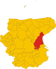
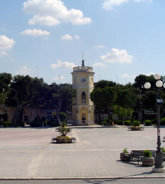
Cerignola (Cerignola)
.svg)
- Italian comune
 Hiking in Cerignola
Cerignola, located in the Apulia region of southern Italy, is not as widely known for hiking as some of its other Italian counterparts, but it offers beautiful landscapes and opportunities for walking and exploring nature.
Key Points for Hiking in Cerignola:
-
Natural Landscapes: The region around Cerignola features a mix of agricultural land, rolling hills, and scenic countryside. This makes for pleasant hiking paths, especially if you enjoy open spaces and views of vineyards and olive groves.
-
Local Trails: While specific hiking trails may not be extensively marked in the Cerignola area, you can find various local paths that connect farms and rural areas. Exploring these can lead to unique experiences in the Italian countryside.
-
Nearby Natural Areas: Consider venturing to nearby natural parks, such as the Gargano National Park or the Alta Murgia National Park. Both are a bit of a drive from Cerignola but offer extensive hiking routes and stunning natural scenery, including cliffs, forests, and diverse wildlife.
-
Cultural and Historical Aspects: Incorporating hikes that start from Cerignola allows hikers to explore local towns and experience the historical aspects of the area. Look for trails that lead to ancient ruins or historical sites for a combined cultural and outdoor experience.
-
Best Time to Hike: The best hiking seasons in this region are spring (March to June) and fall (September to November), when temperatures are more moderate. Summers can be hot and may lead to less comfortable hiking conditions.
-
Safety and Preparedness: Though hiking in the countryside can be idyllic, it’s essential to prepare adequately. Bring sufficient water, food supplies, a map or GPS device, and inform someone about your hiking plans. Some rural areas may not have amenities nearby.
-
Local Guides and Tours: If you’re unfamiliar with the area, consider hiring a local guide for a more enriching experience. They can provide insights into local flora, fauna, and history.
Conclusion:
While Cerignola may not be a mainstream hiking destination, it has its charm and offers opportunities to enjoy the outdoors in a lesser-known part of Italy. Remember to respect the local environment and follow any guidelines posted in rural areas. Happy hiking!
- Country:

- Postal Code: 71042; 71040
- Local Dialing Code: 0885
- Licence Plate Code: FG
- Coordinates: 41° 16' 0" N, 15° 54' 0" E


- GPS tracks (wikiloc): [Link]
- AboveSeaLevel: 120 м m
- Area: 593.93 sq km
- Population: 58540
- Web site: http://www.comune.cerignola.fg.it/
- Wikipedia en: wiki(en)
- Wikipedia: wiki(it)
- Wikidata storage: Wikidata: Q19277
- Wikipedia Commons Gallery: [Link]
- Wikipedia Commons Category: [Link]
- Wikipedia Commons Maps Category: [Link]
- Freebase ID: [/m/08c673]
- GeoNames ID: Alt: [6538923]
- VIAF ID: Alt: [141915771]
- OSM relation ID: [41120]
- MusicBrainz area ID: [9797fbca-48a8-4d8e-a998-4f512c0131ec]
- WOEID: [713793]
- UN/LOCODE: [ITCEA]
- Encyclopædia Britannica Online ID: [place/Cerignola]
- Gran Enciclopèdia Catalana ID: [0017085]
- ISTAT ID: 071020
- Italian cadastre code: C514
Shares border with regions:

Manfredonia
- Italian comune
Hiking in Manfredonia
Manfredonia, located on the Adriatic coast of Italy in the Apulia region, offers a unique blend of natural beauty, cultural heritage, and hiking opportunities. The area is characterized by its stunning coastline, historical sites, and proximity to the Gargano National Park, which is a haven for outdoor enthusiasts....
- Country:
- Postal Code: 71043
- Local Dialing Code: 0884
- Licence Plate Code: FG
- Coordinates: 41° 38' 0" N, 15° 55' 0" E
- GPS tracks (wikiloc): [Link]
- AboveSeaLevel: 5 м m
- Area: 354.54 sq km
- Population: 56906
- Web site: [Link]


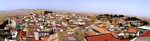
Canosa di Puglia
- town and comune in Apulia in southern Italy
Hiking in Canosa di Puglia
Canosa di Puglia, located in the Apulia region of Italy, offers a unique blend of historical sites and natural beauty that makes it an interesting hiking destination. Here are some key aspects to consider when planning a hiking trip there:...
- Country:
- Postal Code: 76012
- Local Dialing Code: 0883
- Licence Plate Code: BT
- Coordinates: 41° 13' 0" N, 16° 4' 0" E
- GPS tracks (wikiloc): [Link]
- AboveSeaLevel: 105 м m
- Area: 150.93 sq km
- Population: 29847
- Web site: [Link]

San Ferdinando di Puglia
- town in Italy
Hiking in San Ferdinando di Puglia
San Ferdinando di Puglia, located in the Apulia region of Italy, is a charming town surrounded by beautiful landscapes that provide a variety of hiking opportunities. The area is characterized by its flat terrain, agricultural fields, and proximity to the Adriatic Coast, making it suitable for different types of hikes....
- Country:
- Postal Code: 76017
- Local Dialing Code: 0883
- Licence Plate Code: BT
- Coordinates: 41° 18' 0" N, 16° 4' 0" E
- GPS tracks (wikiloc): [Link]
- AboveSeaLevel: 64 м m
- Area: 41.23 sq km
- Population: 13828
- Web site: [Link]


Trinitapoli
- town in Italy
Hiking in Trinitapoli
Trinitapoli is a small town located in the Apulia region of southern Italy, near the Adriatic coast. While it’s not primarily known as a hiking destination, the surrounding area offers various opportunities for outdoor exploration that can appeal to hikers and nature lovers....
- Country:
- Postal Code: 76015
- Local Dialing Code: 0883
- Licence Plate Code: BT
- Coordinates: 41° 21' 0" N, 16° 6' 0" E
- GPS tracks (wikiloc): [Link]
- AboveSeaLevel: 20 м m
- Area: 148.77 sq km
- Population: 14649
- Web site: [Link]

Ascoli Satriano
- Italian comune
Hiking in Ascoli Satriano
Ascoli Satriano, located in the Puglia region of Italy, offers a variety of hiking opportunities amidst stunning landscapes and rich cultural heritage. Here are some key points about hiking in the area:...
- Country:
- Postal Code: 71022
- Local Dialing Code: 0885
- Licence Plate Code: FG
- Coordinates: 41° 12' 56" N, 15° 33' 28" E
- GPS tracks (wikiloc): [Link]
- AboveSeaLevel: 376 м m
- Area: 336.68 sq km
- Population: 6167
- Web site: [Link]
Carapelle
- Italian comune
Hiking in Carapelle
Carapelle, a charming town in the Apulia region of Italy, offers a variety of hiking opportunities, particularly due to its proximity to the beautiful landscapes of the Gargano National Park and the coastal trails along the Adriatic Sea....
- Country:
- Postal Code: 71041
- Local Dialing Code: 0885
- Licence Plate Code: FG
- Coordinates: 41° 22' 0" N, 15° 42' 0" E
- GPS tracks (wikiloc): [Link]
- AboveSeaLevel: 62 м m
- Area: 25 sq km
- Population: 6692
- Web site: [Link]


Ordona
- Italian comune
Hiking in Ordona
Ordona is a small town in the province of Foggia, Italy, and while it may not be as widely recognized for hiking as some other destinations, there are still opportunities for outdoor enthusiasts in the surrounding areas....
- Country:
- Postal Code: 71040
- Local Dialing Code: 0885
- Licence Plate Code: FG
- Coordinates: 41° 19' 0" N, 15° 38' 0" E
- GPS tracks (wikiloc): [Link]
- AboveSeaLevel: 120 м m
- Area: 39.57 sq km
- Population: 2843
- Web site: [Link]
Orta Nova
- Italian comune
Hiking in Orta Nova
Orta Nova is a charming town located in the Apulia region of southern Italy, not far from the beautiful landscapes of the Gargano National Park and the Tavoliere delle Puglie. While the town and its immediate area might not be well-known as a hiking destination, there are still opportunities for nature walks and exploring the countryside....
- Country:
- Postal Code: 71045
- Local Dialing Code: 0885
- Licence Plate Code: FG
- Coordinates: 41° 19' 51" N, 15° 42' 41" E
- GPS tracks (wikiloc): [Link]
- AboveSeaLevel: 70 м m
- Area: 105.24 sq km
- Population: 17675
- Web site: [Link]
Stornara
- Italian comune
Hiking in Stornara
Stornara, located in the Apulia region of southern Italy, is more known for its agricultural landscape than for traditional hiking trails. However, there are opportunities for walking and exploring the natural beauty of the area....
- Country:
- Postal Code: 71047
- Local Dialing Code: 0885
- Licence Plate Code: FG
- Coordinates: 41° 17' 0" N, 15° 46' 0" E
- GPS tracks (wikiloc): [Link]
- AboveSeaLevel: 74 м m
- Area: 33.86 sq km
- Population: 5802
- Web site: [Link]
Stornarella
- Italian comune
Hiking in Stornarella
Stornarella is a small town in the Apulia region of Italy, known for its charming countryside and agricultural landscapes. While it may not be a well-known hiking destination, there are still opportunities for outdoor activities in the surrounding areas. Here are some aspects to consider if you’re interested in hiking around Stornarella:...
- Country:
- Postal Code: 71048
- Local Dialing Code: 0885
- Licence Plate Code: FG
- Coordinates: 41° 15' 0" N, 15° 44' 0" E
- GPS tracks (wikiloc): [Link]
- AboveSeaLevel: 154 м m
- Area: 33.81 sq km
- Population: 5344
- Web site: [Link]


Zapponeta
- Italian comune
Hiking in Zapponeta
Zapponeta is a charming village located in the Apulia region of southern Italy, along the Adriatic coast. While it may not be as widely recognized as some other hiking destinations, it offers opportunities for outdoor enthusiasts to enjoy the natural beauty of the surrounding areas....
- Country:
- Postal Code: 71030
- Local Dialing Code: 0884
- Licence Plate Code: FG
- Coordinates: 41° 27' 0" N, 15° 58' 0" E
- GPS tracks (wikiloc): [Link]
- AboveSeaLevel: 10 м m
- Area: 41.75 sq km
- Population: 3464
- Web site: [Link]
Lavello
- Italian comune
Hiking in Lavello
Lavello is a charming town located in the Basilicata region of southern Italy, surrounded by a beautiful natural landscape often characterized by rolling hills, olive groves, and vineyards. While it may not be as widely known as some other hiking destinations in Italy, it offers some excellent opportunities for outdoor enthusiasts looking to explore the area's natural beauty....
- Country:
- Postal Code: 85024
- Local Dialing Code: 0972
- Coordinates: 41° 3' 0" N, 15° 48' 0" E
- GPS tracks (wikiloc): [Link]
- AboveSeaLevel: 313 м m
- Area: 134.67 sq km
- Population: 13411
- Web site: [Link]