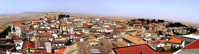
Orta Nova (Orta Nova)
.svg)
- Italian comune
 Hiking in Orta Nova
Orta Nova is a charming town located in the Apulia region of southern Italy, not far from the beautiful landscapes of the Gargano National Park and the Tavoliere delle Puglie. While the town and its immediate area might not be well-known as a hiking destination, there are still opportunities for nature walks and exploring the countryside.
Hiking Opportunities Around Orta Nova
-
Tavoliere delle Puglie: This vast agricultural plain is ideal for flat hikes. It offers a unique landscape with a mix of farmlands, olive groves, and some wetlands. Look for trails that might lead through local farms or along rivers and canals.
-
Gargano National Park: A short drive from Orta Nova, this park is famous for its breathtaking coastal views, mountainous terrain, and dense forests. Here, you can find various marked trails ranging from easy to challenging that meander through the park's diverse ecosystems.
-
Foresta Umbra: Located within the Gargano National Park, this area features dense beech forests and is great for hiking. Trails here vary in difficulty and provide an opportunity to see wildlife and enjoy a cooler climate under the canopy.
-
Local Countryside: Explore the rolling hills and agricultural fields surrounding Orta Nova. Many small dirt roads and paths are suitable for leisurely walks or easier hikes.
Tips for Hiking in the Area
- Wear suitable footwear: Sturdy hiking boots are recommended, especially if you plan to venture into the national parks.
- Stay hydrated: Always carry enough water, especially in the warmer months.
- Check the weather: The climate can vary; ensure that you're prepared for changes in weather conditions.
- Guided tours: Consider joining a local hiking group or guided tour to get more insight into the area’s flora, fauna, and cultural heritage.
- Be mindful of the environment: Respect local wildlife and plants, and follow Leave No Trace principles.
Conclusion
While Orta Nova itself may not be a prominent hiking hub, its proximity to various natural parks and scenic areas make it a great base for outdoor enthusiasts looking to explore the diverse landscapes of Apulia. Whether you're wandering through the flat plains of Tavoliere or descending into the rich woodlands of Gargano, there's plenty of beauty to discover!
- Country:

- Postal Code: 71045
- Local Dialing Code: 0885
- Licence Plate Code: FG
- Coordinates: 41° 19' 51" N, 15° 42' 41" E


- GPS tracks (wikiloc): [Link]
- AboveSeaLevel: 70 м m
- Area: 105.24 sq km
- Population: 17675
- Web site: http://www.cittaortanova-fg.it/
- Wikipedia en: wiki(en)
- Wikipedia: wiki(it)
- Wikidata storage: Wikidata: Q51940
- Wikipedia Commons Category: [Link]
- Freebase ID: [/m/0fz6b5]
- GeoNames ID: Alt: [6541936]
- VIAF ID: Alt: [130532244]
- OSM relation ID: [41194]
- MusicBrainz area ID: [1961af11-9900-4a3f-8ea3-a97d224efef4]
- UN/LOCODE: [ITORT]
- ISTAT ID: 071036
- Italian cadastre code: G131
Shares border with regions:


Cerignola
- Italian comune
Hiking in Cerignola
Cerignola, located in the Apulia region of southern Italy, is not as widely known for hiking as some of its other Italian counterparts, but it offers beautiful landscapes and opportunities for walking and exploring nature....
- Country:
- Postal Code: 71042; 71040
- Local Dialing Code: 0885
- Licence Plate Code: FG
- Coordinates: 41° 16' 0" N, 15° 54' 0" E
- GPS tracks (wikiloc): [Link]
- AboveSeaLevel: 120 м m
- Area: 593.93 sq km
- Population: 58540
- Web site: [Link]

Ascoli Satriano
- Italian comune
Hiking in Ascoli Satriano
Ascoli Satriano, located in the Puglia region of Italy, offers a variety of hiking opportunities amidst stunning landscapes and rich cultural heritage. Here are some key points about hiking in the area:...
- Country:
- Postal Code: 71022
- Local Dialing Code: 0885
- Licence Plate Code: FG
- Coordinates: 41° 12' 56" N, 15° 33' 28" E
- GPS tracks (wikiloc): [Link]
- AboveSeaLevel: 376 м m
- Area: 336.68 sq km
- Population: 6167
- Web site: [Link]
Carapelle
- Italian comune
Hiking in Carapelle
Carapelle, a charming town in the Apulia region of Italy, offers a variety of hiking opportunities, particularly due to its proximity to the beautiful landscapes of the Gargano National Park and the coastal trails along the Adriatic Sea....
- Country:
- Postal Code: 71041
- Local Dialing Code: 0885
- Licence Plate Code: FG
- Coordinates: 41° 22' 0" N, 15° 42' 0" E
- GPS tracks (wikiloc): [Link]
- AboveSeaLevel: 62 м m
- Area: 25 sq km
- Population: 6692
- Web site: [Link]


Ordona
- Italian comune
Hiking in Ordona
Ordona is a small town in the province of Foggia, Italy, and while it may not be as widely recognized for hiking as some other destinations, there are still opportunities for outdoor enthusiasts in the surrounding areas....
- Country:
- Postal Code: 71040
- Local Dialing Code: 0885
- Licence Plate Code: FG
- Coordinates: 41° 19' 0" N, 15° 38' 0" E
- GPS tracks (wikiloc): [Link]
- AboveSeaLevel: 120 м m
- Area: 39.57 sq km
- Population: 2843
- Web site: [Link]
Stornara
- Italian comune
Hiking in Stornara
Stornara, located in the Apulia region of southern Italy, is more known for its agricultural landscape than for traditional hiking trails. However, there are opportunities for walking and exploring the natural beauty of the area....
- Country:
- Postal Code: 71047
- Local Dialing Code: 0885
- Licence Plate Code: FG
- Coordinates: 41° 17' 0" N, 15° 46' 0" E
- GPS tracks (wikiloc): [Link]
- AboveSeaLevel: 74 м m
- Area: 33.86 sq km
- Population: 5802
- Web site: [Link]
Stornarella
- Italian comune
Hiking in Stornarella
Stornarella is a small town in the Apulia region of Italy, known for its charming countryside and agricultural landscapes. While it may not be a well-known hiking destination, there are still opportunities for outdoor activities in the surrounding areas. Here are some aspects to consider if you’re interested in hiking around Stornarella:...
- Country:
- Postal Code: 71048
- Local Dialing Code: 0885
- Licence Plate Code: FG
- Coordinates: 41° 15' 0" N, 15° 44' 0" E
- GPS tracks (wikiloc): [Link]
- AboveSeaLevel: 154 м m
- Area: 33.81 sq km
- Population: 5344
- Web site: [Link]