Champrepus (Champrepus)

- commune in Manche, France
- Country:

- Postal Code: 50800
- Coordinates: 48° 50' 2" N, 1° 19' 16" E


- GPS tracks (wikiloc): [Link]
- Area: 9.12 sq km
- Population: 335
- Wikipedia en: wiki(en)
- Wikipedia: wiki(fr)
- Wikidata storage: Wikidata: Q924321
- Wikipedia Commons Category: [Link]
- Freebase ID: [/m/03qcqs8]
- Freebase ID: [/m/03qcqs8]
- GeoNames ID: Alt: [6614927]
- GeoNames ID: Alt: [6614927]
- SIREN number: [215001181]
- SIREN number: [215001181]
- BnF ID: [15262095f]
- BnF ID: [15262095f]
- WOEID: [584329]
- WOEID: [584329]
- INSEE municipality code: 50118
- INSEE municipality code: 50118
Shares border with regions:


Beauchamps
- commune in Manche, France
- Country:
- Postal Code: 50320
- Coordinates: 48° 49' 56" N, 1° 21' 32" E
- GPS tracks (wikiloc): [Link]
- Area: 4.1 sq km
- Population: 393

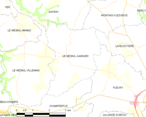
Le Mesnil-Garnier
- commune in Manche, France
- Country:
- Postal Code: 50450
- Coordinates: 48° 51' 55" N, 1° 18' 35" E
- GPS tracks (wikiloc): [Link]
- Area: 10.41 sq km
- Population: 232


La Lande-d'Airou
- commune in Manche, France
- Country:
- Postal Code: 50800
- Coordinates: 48° 48' 58" N, 1° 17' 25" E
- GPS tracks (wikiloc): [Link]
- Area: 15.1 sq km
- Population: 514


Le Mesnil-Villeman
- commune in Manche, France
- Country:
- Postal Code: 50450
- Coordinates: 48° 51' 52" N, 1° 19' 39" E
- GPS tracks (wikiloc): [Link]
- Area: 10.8 sq km
- Population: 240
- Web site: [Link]


Le Tanu
- commune in Manche, France
- Country:
- Postal Code: 50320
- Coordinates: 48° 48' 59" N, 1° 20' 43" E
- GPS tracks (wikiloc): [Link]
- Area: 10.12 sq km
- Population: 376


La Haye-Pesnel
- commune in Manche, France
- Country:
- Postal Code: 50320
- Coordinates: 48° 47' 44" N, 1° 23' 48" E
- GPS tracks (wikiloc): [Link]
- Area: 6.29 sq km
- Population: 1360

Fleury
- commune in Manche, France
- Country:
- Postal Code: 50800
- Coordinates: 48° 50' 52" N, 1° 16' 33" E
- GPS tracks (wikiloc): [Link]
- Area: 12.6 sq km
- Population: 1052