Charantonnay (Charantonnay)

- commune in Isère, France
 Hiking in Charantonnay
Charantonnay is a charming municipality located in the Auvergne-Rhône-Alpes region of France, which is known for its beautiful landscapes and outdoor activities. Although it's a smaller village, it offers access to some lovely hiking opportunities in the surrounding areas. Here are some key points to consider for hiking in and around Charantonnay:
Scenic Trails
- Local Trails: Charantonnay has several marked paths that take you through the picturesque countryside, offering views of rolling hills, vineyards, and fields.
- Forested Areas: The vicinity is dotted with forests that provide shaded trails for comfortable hiking, particularly in warmer months.
Nearby Natural Attractions
- Vercors Regional Natural Park: A short drive from Charantonnay, this park offers a wealth of hiking opportunities, ranging from easy walks to challenging trails with spectacular views of the mountains and unique geological formations.
- Chartreuse Mountains: Located to the east, the Chartreuse Mountains offer rugged terrain and stunning vistas, ideal for more experienced hikers.
Tips for Hiking in Charantonnay
- Seasonal Considerations: Spring and fall are generally the best seasons for hiking in this area due to mild weather. Summer can be warm, and winter may bring snow to the higher elevations.
- Local Regulations: Always check for any local trails or park regulations, including specific rules about dogs, camping, or trail usage.
- Safety: Bring plenty of water, wear appropriate footwear, and don’t forget to carry a map or use a reliable navigation app to stay oriented.
Cultural Discoveries
While hiking, you may also encounter local farms, charming villages, and historical sites, allowing you to experience and appreciate the local culture and history.
In conclusion, while Charantonnay itself may not be a hiking hotspot, its location provides access to numerous scenic trails and natural parks that are perfect for outdoor enthusiasts.
- Country:

- Postal Code: 38790
- Coordinates: 45° 32' 13" N, 5° 6' 29" E


- GPS tracks (wikiloc): [Link]
- Area: 11 sq km
- Population: 1853
- Web site: http://www.charantonnay.fr
- Wikipedia en: wiki(en)
- Wikipedia: wiki(fr)
- Wikidata storage: Wikidata: Q1069595
- Wikipedia Commons Category: [Link]
- Freebase ID: [/m/03nvgfg]
- GeoNames ID: Alt: [6448749]
- SIREN number: [213800816]
- BnF ID: [15257909h]
- INSEE municipality code: 38081
Shares border with regions:

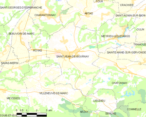
Saint-Jean-de-Bournay
- commune in Isère, France
Hiking in Saint-Jean-de-Bournay
Saint-Jean-de-Bournay is a charming commune located in the Isère department of the Auvergne-Rhône-Alpes region in southeastern France. The surrounding area is characterized by diverse landscapes, including low valleys, rolling hills, and scenic views, making it a great destination for hiking enthusiasts....
- Country:
- Postal Code: 38440
- Coordinates: 45° 30' 8" N, 5° 8' 16" E
- GPS tracks (wikiloc): [Link]
- Area: 26.87 sq km
- Population: 4622
- Web site: [Link]

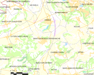
Saint-Georges-d'Espéranche
- commune in Isère, France
Hiking in Saint-Georges-d'Espéranche
Saint-Georges-d'Espéranche is a charming commune located in the Isère department of the Auvergne-Rhône-Alpes region in southeastern France. While it may not be as widely known as some other hiking destinations in the region, it offers a range of outdoor activities and scenic landscapes that are perfect for hiking enthusiasts....
- Country:
- Postal Code: 38790
- Coordinates: 45° 33' 21" N, 5° 4' 39" E
- GPS tracks (wikiloc): [Link]
- Area: 24.65 sq km
- Population: 3321
- Web site: [Link]


Roche
- commune in Isère, France
Hiking in Roche
Roche, located in the Isère department of southeastern France, offers a variety of hiking opportunities in a stunning natural setting. The region is characterized by its beautiful mountains, valleys, and diverse landscapes, making it an excellent destination for hiking enthusiasts....
- Country:
- Postal Code: 38090
- Coordinates: 45° 35' 20" N, 5° 9' 34" E
- GPS tracks (wikiloc): [Link]
- AboveSeaLevel: 230 м m
- Area: 20.14 sq km
- Population: 1926
- Web site: [Link]

Artas
- commune in Isère, France
Hiking in Artas
Artas, located in the Isère department of the Auvergne-Rhône-Alpes region in southeastern France, is known for its beautiful landscapes and diverse hiking opportunities. Though small, the area surrounding Artas features a variety of trails that cater to different levels of hikers, from beginners to more experienced mountain trekkers....
- Country:
- Postal Code: 38440
- Coordinates: 45° 32' 7" N, 5° 9' 52" E
- GPS tracks (wikiloc): [Link]
- Area: 14.15 sq km
- Population: 1817
- Web site: [Link]

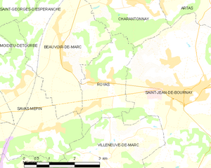
Royas
- commune in Isère, France
Hiking in Royas
Royas is a beautiful yet lesser-known hiking destination, perfect for those looking to explore nature away from the more crowded trails. Although it might not be as famous as other hiking spots, it offers stunning landscapes, diverse wildlife, and a peaceful atmosphere....
- Country:
- Postal Code: 38440
- Coordinates: 45° 30' 21" N, 5° 6' 16" E
- GPS tracks (wikiloc): [Link]
- Area: 5.48 sq km
- Population: 389
- Web site: [Link]


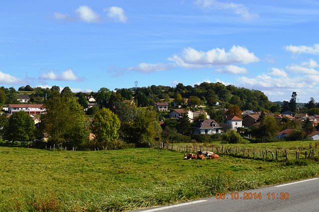
Beauvoir-de-Marc
- commune in Isère, France
Hiking in Beauvoir-de-Marc
Beauvoir-de-Marc is a charming commune located in the Isère department of the Auvergne-Rhône-Alpes region in southeastern France. While it may not be as widely recognized as some other hiking destinations, it offers a variety of scenic trails and outdoor activities that can be enjoyed by hikers of all levels....
- Country:
- Postal Code: 38440
- Coordinates: 45° 31' 7" N, 5° 4' 45" E
- GPS tracks (wikiloc): [Link]
- Area: 11.27 sq km
- Population: 1140
- Web site: [Link]