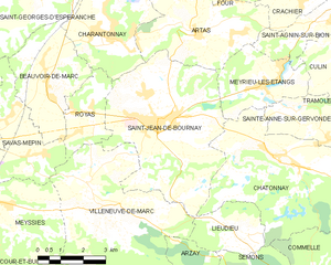
Royas (Royas)

- commune in Isère, France
 Hiking in Royas
Royas is a beautiful yet lesser-known hiking destination, perfect for those looking to explore nature away from the more crowded trails. Although it might not be as famous as other hiking spots, it offers stunning landscapes, diverse wildlife, and a peaceful atmosphere.
Key Highlights:
-
Scenic Views: Expect breathtaking views of mountains, forests, and possibly waterfalls, depending on the specific trails you choose.
-
Trail Variety: There are usually trails suitable for all skill levels, from easy walks for beginners to more challenging hikes for experienced trekkers.
-
Wildlife Encounters: The area is often rich in biodiversity, offering opportunities to spot various animals and birds in their natural habitat.
-
Local Flora: Depending on the season, you may encounter a variety of wildflowers, trees, and plants unique to the region.
-
Cultural Insights: Some trails might pass by historical landmarks or offer insights into the local culture and heritage, adding a layer of interest to your hike.
Tips for Hiking in Royas:
-
Check Trail Conditions: Before heading out, check local guides or websites for trail conditions, as they can change with weather.
-
Pack Essentials: Always bring plenty of water, snacks, a first-aid kit, and appropriate clothing for changing weather conditions.
-
Leave No Trace: Follow the principles of Leave No Trace to protect the natural beauty of Royas.
-
Safety First: Make sure someone knows your hiking plans, especially if you plan to go solo.
-
Plan for Time: Some trails may take longer than expected, so start early and allow for extra time for exploration or breaks.
Best Times to Visit:
- Spring and Fall: These seasons typically offer mild weather and fantastic scenery with blooming flowers in spring or vibrant leaves in the fall.
Hiking in Royas can be a rewarding experience. Just remember to prepare well and respect the natural environment. Enjoy your adventure!
- Country:

- Postal Code: 38440
- Coordinates: 45° 30' 21" N, 5° 6' 16" E


- GPS tracks (wikiloc): [Link]
- Area: 5.48 sq km
- Population: 389
- Web site: http://www.royas.fr
- Wikipedia en: wiki(en)
- Wikipedia: wiki(fr)
- Wikidata storage: Wikidata: Q634390
- Wikipedia Commons Category: [Link]
- Freebase ID: [/m/03bxvvr]
- GeoNames ID: Alt: [6433310]
- SIREN number: [213803463]
- BnF ID: [15258157d]
- VIAF ID: Alt: [239207975]
- INSEE municipality code: 38346
Shares border with regions:

Saint-Jean-de-Bournay
- commune in Isère, France
Hiking in Saint-Jean-de-Bournay
Saint-Jean-de-Bournay is a charming commune located in the Isère department of the Auvergne-Rhône-Alpes region in southeastern France. The surrounding area is characterized by diverse landscapes, including low valleys, rolling hills, and scenic views, making it a great destination for hiking enthusiasts....
- Country:
- Postal Code: 38440
- Coordinates: 45° 30' 8" N, 5° 8' 16" E
- GPS tracks (wikiloc): [Link]
- Area: 26.87 sq km
- Population: 4622
- Web site: [Link]


Villeneuve-de-Marc
- commune in Isère, France
Hiking in Villeneuve-de-Marc
Villeneuve-de-Marc is a charming village located in the Auvergne-Rhône-Alpes region of France. It's situated near the Rhône River and offers a picturesque landscape that is perfect for hiking enthusiasts. Here are some details to help you plan a hiking trip in and around Villeneuve-de-Marc:...
- Country:
- Postal Code: 38440
- Coordinates: 45° 28' 33" N, 5° 6' 8" E
- GPS tracks (wikiloc): [Link]
- Area: 26.18 sq km
- Population: 1140
- Web site: [Link]


Savas-Mépin
- commune in Isère, France
Hiking in Savas-Mépin
Savas-Mépin is a small commune located in the Auvergne-Rhône-Alpes region of southeastern France, known for its scenic natural landscapes and outdoor activities, including hiking. While being less well-known than some major hiking destinations in the Alps or the Vercors region, Savas-Mépin offers a peaceful environment for outdoor enthusiasts....
- Country:
- Postal Code: 38440
- Coordinates: 45° 29' 22" N, 5° 4' 16" E
- GPS tracks (wikiloc): [Link]
- Area: 10.43 sq km
- Population: 869
- Web site: [Link]


Charantonnay
- commune in Isère, France
Hiking in Charantonnay
Charantonnay is a charming municipality located in the Auvergne-Rhône-Alpes region of France, which is known for its beautiful landscapes and outdoor activities. Although it's a smaller village, it offers access to some lovely hiking opportunities in the surrounding areas. Here are some key points to consider for hiking in and around Charantonnay:...
- Country:
- Postal Code: 38790
- Coordinates: 45° 32' 13" N, 5° 6' 29" E
- GPS tracks (wikiloc): [Link]
- Area: 11 sq km
- Population: 1853
- Web site: [Link]


Beauvoir-de-Marc
- commune in Isère, France
Hiking in Beauvoir-de-Marc
Beauvoir-de-Marc is a charming commune located in the Isère department of the Auvergne-Rhône-Alpes region in southeastern France. While it may not be as widely recognized as some other hiking destinations, it offers a variety of scenic trails and outdoor activities that can be enjoyed by hikers of all levels....
- Country:
- Postal Code: 38440
- Coordinates: 45° 31' 7" N, 5° 4' 45" E
- GPS tracks (wikiloc): [Link]
- Area: 11.27 sq km
- Population: 1140
- Web site: [Link]