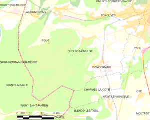
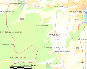
Charmes-la-Côte (Charmes-la-Côte)

- commune in Meurthe-et-Moselle, France
- Country:

- Postal Code: 54113
- Coordinates: 48° 37' 32" N, 5° 49' 39" E


- GPS tracks (wikiloc): [Link]
- Area: 6.23 sq km
- Population: 342
- Wikipedia en: wiki(en)
- Wikipedia: wiki(fr)
- Wikidata storage: Wikidata: Q1085887
- Wikipedia Commons Category: [Link]
- Freebase ID: [/m/03qdg59]
- Freebase ID: [/m/03qdg59]
- GeoNames ID: Alt: [3026579]
- GeoNames ID: Alt: [3026579]
- SIREN number: [215401209]
- SIREN number: [215401209]
- BnF ID: [152641898]
- BnF ID: [152641898]
- INSEE municipality code: 54120
- INSEE municipality code: 54120
Shares border with regions:

Choloy-Ménillot
- commune in Meurthe-et-Moselle, France
- Country:
- Postal Code: 54200
- Coordinates: 48° 39' 43" N, 5° 49' 9" E
- GPS tracks (wikiloc): [Link]
- AboveSeaLevel: 249 м m
- Area: 11.95 sq km
- Population: 726

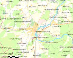
Toul
- commune in Meurthe-et-Moselle, France
- Country:
- Postal Code: 54200
- Coordinates: 48° 40' 30" N, 5° 53' 30" E
- GPS tracks (wikiloc): [Link]
- AboveSeaLevel: 215 м m
- Area: 30.59 sq km
- Population: 16021
- Web site: [Link]

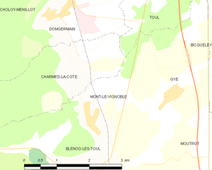
Mont-le-Vignoble
- commune in Meurthe-et-Moselle, France
- Country:
- Postal Code: 54113
- Coordinates: 48° 36' 47" N, 5° 50' 26" E
- GPS tracks (wikiloc): [Link]
- Area: 4.12 sq km
- Population: 419

Domgermain
- commune in Meurthe-et-Moselle, France
- Country:
- Postal Code: 54119
- Coordinates: 48° 38' 33" N, 5° 49' 33" E
- GPS tracks (wikiloc): [Link]
- Area: 13.09 sq km
- Population: 1220


Rigny-Saint-Martin
- commune in Meuse, France
- Country:
- Postal Code: 55140
- Coordinates: 48° 36' 40" N, 5° 42' 51" E
- GPS tracks (wikiloc): [Link]
- Area: 16.11 sq km
- Population: 56

Blénod-lès-Toul
- commune in Meurthe-et-Moselle, France
- Country:
- Postal Code: 54113
- Coordinates: 48° 35' 58" N, 5° 50' 0" E
- GPS tracks (wikiloc): [Link]
- Area: 17.6 sq km
- Population: 1089