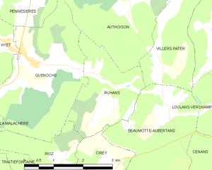
Cirey (Cirey)

- commune in Haute-Saône, France
 Hiking in Cirey
Cirey is a small commune located in the Haute-Marne department in northeastern France. While it may not be as widely recognized as larger hiking destinations, it offers beautiful landscapes and opportunities for outdoor activities, especially for those who enjoy peaceful rural settings.
Hiking Trails
-
Scenic Routes: The region around Cirey is characterized by rolling hills, forests, and farmland. Trails may take you through picturesque countryside, offering the chance to explore local flora and fauna.
-
GR Trails: Check for nearby Grande Randonnée (GR) routes, which are long-distance walking trails across France. While specific trails may not pass directly through Cirey, you might find sections that can be accessed from nearby areas.
-
Nature Reserves: Explore any local nature reserves or parks that may offer marked hiking trails. They often provide a chance to see wildlife and enjoy unspoiled landscapes.
Preparation
-
Maps and Resources: Use local maps or hiking apps to familiarize yourself with trails in the area. Local tourist offices can provide valuable information on recommended routes.
-
Gear: Dress in layers and wear sturdy hiking boots. Bring a daypack with water, snacks, a first-aid kit, and navigation tools.
-
Weather: Check the weather forecast before heading out. Conditions can change rapidly, especially in more remote areas.
Safety Tips
-
Trail Etiquette: Stay on marked trails to minimize environmental impact and follow local guidelines regarding wildlife and plant protection.
-
Group Hiking: If you're unfamiliar with the area, consider hiking with a group or local guide, especially in less traveled areas.
Nearby Attractions
-
Historical Sites: Explore the local history, as Cirey is near places of interest related to French history and architecture.
-
Cultural Experiences: Don’t miss opportunities to enjoy local cuisine and culture, which can enrich your hiking experience.
Conclusion
Hiking around Cirey offers a chance to enjoy the serene beauty of rural France, perfect for those looking to escape the hustle and bustle of city life. Always be prepared and respect nature, and you’ll have a rewarding hiking experience!
- Country:

- Postal Code: 70190
- Coordinates: 47° 23' 47" N, 6° 7' 57" E


- GPS tracks (wikiloc): [Link]
- Area: 13.09 sq km
- Population: 358
- Web site: http://www.cirey.fr/
- Wikipedia en: wiki(en)
- Wikipedia: wiki(fr)
- Wikidata storage: Wikidata: Q817024
- Wikipedia Commons Category: [Link]
- Freebase ID: [/m/05b_nr]
- GeoNames ID: Alt: [6441878]
- SIREN number: [217001544]
- BnF ID: [15272548h]
- PACTOLS thesaurus ID: [pcrtRKLFw5aI0f]
- INSEE municipality code: 70154
Shares border with regions:


Rigney
- commune in Doubs, France
Hiking in Rigney
It seems that there isn't a well-known hiking area specifically named "Rigney." However, if you're referring to a specific location related to hiking, please clarify, and I would be glad to provide information!...
- Country:
- Postal Code: 25640
- Coordinates: 47° 23' 17" N, 6° 10' 33" E
- GPS tracks (wikiloc): [Link]
- Area: 9.58 sq km
- Population: 406
- Web site: [Link]


Vandelans
- commune in Haute-Saône, France
Hiking in Vandelans
It seems there might be a small misunderstanding, as "Vandelans" doesn’t appear to refer to a well-known hiking destination or location that I am aware of as of my last knowledge update in October 2023. However, if you meant a different location or if "Vandelans" is a local term or a lesser-known area, I’d be happy to provide general hiking information or tips, or discuss hikes in popular areas....
- Country:
- Postal Code: 70190
- Coordinates: 47° 23' 41" N, 6° 9' 53" E
- GPS tracks (wikiloc): [Link]
- Area: 3.08 sq km
- Population: 118


Beaumotte-Aubertans
- commune in Haute-Saône, France
Hiking in Beaumotte-Aubertans
Beaumotte-Aubertans is a picturesque commune located in the Bourgogne-Franche-Comté region of France. While not as famous as some larger hiking destinations, the area offers a great opportunity for outdoor enthusiasts to explore beautiful landscapes, including rolling hills, forests, and charming rural scenery....
- Country:
- Postal Code: 70190
- Coordinates: 47° 25' 12" N, 6° 10' 45" E
- GPS tracks (wikiloc): [Link]
- AboveSeaLevel: 270 м m
- Area: 13.57 sq km
- Population: 431


Chambornay-lès-Bellevaux
- commune in Haute-Saône, France
Hiking in Chambornay-lès-Bellevaux
Chambornay-lès-Bellevaux is a charming village located in the Haute-Saône department of France, known for its beautiful natural landscapes and outdoor activities, including hiking. Here are some key points to consider if you're planning a hiking trip in the area:...
- Country:
- Postal Code: 70190
- Coordinates: 47° 23' 27" N, 6° 6' 23" E
- GPS tracks (wikiloc): [Link]
- Area: 5.89 sq km
- Population: 181


Traitiéfontaine
- commune in Haute-Saône, France
- Country:
- Postal Code: 70190
- Coordinates: 47° 24' 54" N, 6° 5' 25" E
- GPS tracks (wikiloc): [Link]
- Area: 5.92 sq km
- Population: 161


Rioz
- commune in Haute-Saône, France
- Country:
- Postal Code: 70190
- Coordinates: 47° 25' 27" N, 6° 4' 12" E
- GPS tracks (wikiloc): [Link]
- Area: 17.2 sq km
- Population: 2202
- Web site: [Link]

Ruhans
- commune in Haute-Saône, France
- Country:
- Postal Code: 70190
- Coordinates: 47° 27' 33" N, 6° 8' 10" E
- GPS tracks (wikiloc): [Link]
- Area: 4.95 sq km
- Population: 160


Valleroy
- commune in Doubs, France
Hiking in Valleroy
Valleroy, located in the Doubs department of France in the region of Bourgogne-Franche-Comté, is a charming area for hiking enthusiasts. Nestled within the picturesque Jura mountains, Valleroy offers a variety of trails suitable for different skill levels, from casual walkers to experienced hikers....
- Country:
- Postal Code: 25870
- Coordinates: 47° 23' 12" N, 6° 7' 5" E
- GPS tracks (wikiloc): [Link]
- Area: 3.05 sq km
- Population: 163