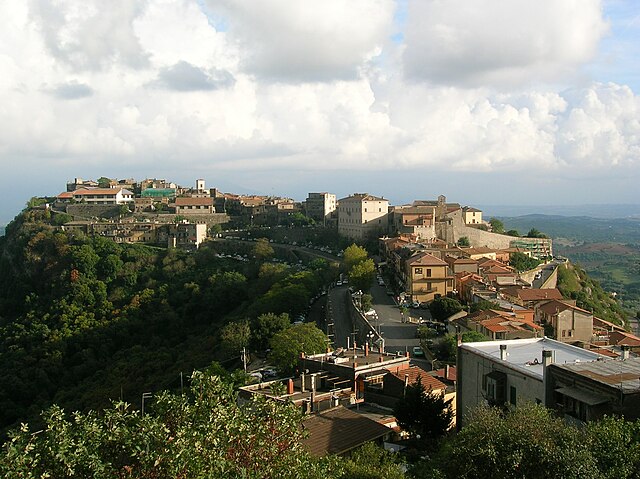
Civitella San Paolo (Civitella San Paolo)
.svg)
- Italian comune
 Hiking in Civitella San Paolo
Civitella San Paolo is a picturesque village located in the Lazio region of Italy, not far from Rome. It offers a charming blend of cultural heritage and natural beauty, making it an appealing destination for hikers and outdoor enthusiasts.
Hiking Trails
-
Natural Surroundings: The area around Civitella San Paolo is characterized by rolling hills, lush forests, and scenic views. The trails often wind through olive groves and vineyards, providing a great opportunity to experience the local agrarian lifestyle.
-
Easy to Moderate Trails: Many of the hiking trails in this region range from easy to moderate difficulty, making them accessible to hikers of all skill levels. The paths are generally well-marked, but local maps or a hiking app can be useful for navigation.
-
Historical Context: As you hike, you might come across historical ruins or old churches that are scattered throughout the landscape. These sites offer insight into the rich history of the area.
-
Flora and Fauna: The region is home to diverse plant and animal life. Keep an eye out for local wildlife, including birds and small mammals, as well as various species of wildflowers, especially in spring.
Tips for Hiking in Civitella San Paolo
-
Best Time to Visit: Spring (April to June) and fall (September to October) are ideal seasons for hiking, as the weather is typically mild and the countryside is at its most beautiful.
-
What to Bring: Essential gear includes sturdy hiking shoes, water, snacks, sun protection, and a camera to capture the stunning views.
-
Local Guidance: Consider joining a guided hike if you’re unfamiliar with the area. Local guides can provide insights into the terrain, flora, and history while ensuring you stay on the best paths.
-
Respect Nature: Follow the principles of Leave No Trace. Stay on marked trails and avoid disturbing the local wildlife.
Additional Activities
In addition to hiking, Civitella San Paolo offers opportunities for cultural exploration. Enjoy local cuisine in traditional restaurants, visit art galleries, or participate in local festivals, if your visit coincides with one.
With its natural beauty, historical charm, and trails for all abilities, Civitella San Paolo can be a rewarding destination for hikers looking to explore the Italian countryside!
- Country:

- Postal Code: 00060
- Local Dialing Code: 0765
- Licence Plate Code: RM
- Coordinates: 42° 11' 45" N, 12° 34' 56" E


- GPS tracks (wikiloc): [Link]
- AboveSeaLevel: 195 м m
- Area: 20.75 sq km
- Population: 2049
- Web site: http://www.comunecivitellasanpaolo.it/it/
- Wikipedia en: wiki(en)
- Wikipedia: wiki(it)
- Wikidata storage: Wikidata: Q242539
- Wikipedia Commons Category: [Link]
- Freebase ID: [/m/0gm75s]
- GeoNames ID: Alt: [6536946]
- VIAF ID: Alt: [123569252]
- OSM relation ID: [41843]
- WOEID: [714202]
- TGN ID: [7047578]
- ISTAT ID: 058033
- Italian cadastre code: C784
Shares border with regions:


Capena
- Italian comune
Hiking in Capena
Capena is a charming town located in the Lazio region of Italy, close to Rome, and offers several hiking opportunities for both beginners and experienced hikers. The surrounding area features a mix of natural beauty and historical significance, making it an attractive destination for outdoor enthusiasts....
- Country:
- Postal Code: 00060
- Local Dialing Code: 06
- Licence Plate Code: ROMA
- Coordinates: 42° 8' 25" N, 12° 32' 25" E
- GPS tracks (wikiloc): [Link]
- AboveSeaLevel: 160 м m
- Area: 29.51 sq km
- Population: 10799
- Web site: [Link]


Fiano Romano
- Italian comune
Hiking in Fiano Romano
Fiano Romano is a charming town located in the Province of Rome, Italy. It's situated near the ancient Via Flaminia, making it not just historically significant but also a great starting point for outdoor activities, particularly hiking....
- Country:
- Postal Code: 00065
- Local Dialing Code: 0765
- Licence Plate Code: ROMA
- Coordinates: 42° 10' 0" N, 12° 36' 0" E
- GPS tracks (wikiloc): [Link]
- AboveSeaLevel: 97 м m
- Area: 41.19 sq km
- Population: 15688
- Web site: [Link]


Nazzano
- Italian comune
Hiking in Nazzano
Nazzano, located in the Lazio region of Italy, offers a beautiful setting for hiking enthusiasts, characterized by a combination of scenic landscapes, historical sites, and rich biodiversity. The area is particularly known for the Nazzano Tevere-Farfa Natural Reserve, where you can enjoy various trails amidst lush forests, riverbanks, and wetlands....
- Country:
- Postal Code: 00060
- Local Dialing Code: 0765
- Licence Plate Code: RM
- Coordinates: 42° 13' 49" N, 12° 35' 40" E
- GPS tracks (wikiloc): [Link]
- AboveSeaLevel: 202 м m
- Area: 12.4 sq km
- Population: 1395
- Web site: [Link]


Ponzano Romano
- Italian comune
Hiking in Ponzano Romano
Ponzano Romano, located in the Lazio region of Italy, near Rome, offers hikers a variety of scenic trails and beautiful landscapes. The area is characterized by its rolling hills, lush vegetation, and picturesque views of the Tiber Valley. Here are some highlights and tips for hiking in Ponzano Romano:...
- Country:
- Postal Code: 00060
- Local Dialing Code: 0765
- Licence Plate Code: RM
- Coordinates: 42° 15' 29" N, 12° 34' 18" E
- GPS tracks (wikiloc): [Link]
- AboveSeaLevel: 205 м m
- Area: 19.52 sq km
- Population: 1140
- Web site: [Link]


Rignano Flaminio
- Italian comune
Hiking in Rignano Flaminio
Rignano Flaminio is a charming town located in the Lazio region of Italy, just north of Rome. This area is known for its beautiful landscapes, rich history, and proximity to the Tiber River, making it a great destination for hiking enthusiasts....
- Country:
- Postal Code: 00068
- Local Dialing Code: 0761
- Licence Plate Code: ROMA
- Coordinates: 42° 12' 0" N, 12° 29' 0" E
- GPS tracks (wikiloc): [Link]
- AboveSeaLevel: 250 м m
- Area: 38.56 sq km
- Population: 10328
- Web site: [Link]

Sant'Oreste
- Italian comune
Hiking in Sant'Oreste
Sant'Oreste is a picturesque town in the Lazio region of Italy, surrounded by lush landscapes and rich history. It is located near the ancient Roman road called the Via Flaminia, making it a great starting point for various hiking trails....
- Country:
- Postal Code: 00060
- Local Dialing Code: 0761
- Licence Plate Code: ROMA
- Coordinates: 42° 14' 0" N, 12° 31' 0" E
- GPS tracks (wikiloc): [Link]
- AboveSeaLevel: 420 м m
- Area: 43.89 sq km
- Population: 3648
- Web site: [Link]