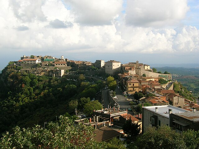
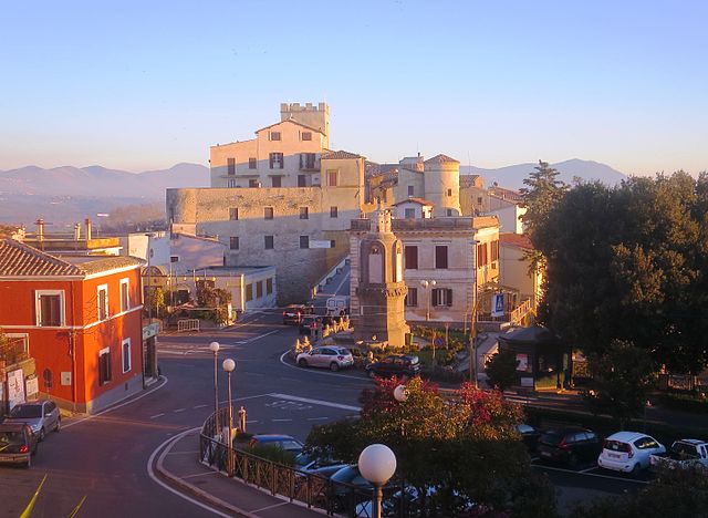
Nazzano (Nazzano)
.svg)
- Italian comune
 Hiking in Nazzano
Nazzano, located in the Lazio region of Italy, offers a beautiful setting for hiking enthusiasts, characterized by a combination of scenic landscapes, historical sites, and rich biodiversity. The area is particularly known for the Nazzano Tevere-Farfa Natural Reserve, where you can enjoy various trails amidst lush forests, riverbanks, and wetlands.
Key Features of Hiking in Nazzano:
-
Nature Trails: The natural reserve has several marked hiking trails ranging from easy to moderate difficulty. These trails allow hikers to explore the local flora and fauna, including diverse bird species, making it a popular spot for birdwatching.
-
Cultural Heritage: Along the hiking routes, you may encounter historical landmarks, including ancient ruins and charming picturesque villages. The town of Nazzano itself has historical significance and adds a cultural dimension to your hiking experience.
-
Scenic Views: Many trails offer stunning views of the Tiber River and surrounding valleys. The landscape changes with the seasons, providing different experiences throughout the year.
-
Accessibility: Nazzano is accessible from Rome, making it a feasible day trip for city dwellers looking for a nature escape. Ensure to check public transport options or consider driving if you have the means.
-
Wildlife Spotting: The area is rich in biodiversity; you may encounter various wildlife, including deer, foxes, and numerous bird species, especially in the wetlands and along the river.
Hiking Tips:
- Prepare for the Weather: Check the local weather conditions before you head out, as they can change quickly. Dress in layers and bring rain gear if necessary.
- Stay on Marked Trails: To preserve the natural ecosystem, it’s important to stick to marked paths and respect local wildlife.
- Hydration and Snacks: Bring plenty of water and some snacks to keep your energy up along the way.
- Safety First: Always inform someone about your hiking plans and estimated return time. Carry a map or a GPS device, as cell service may be unreliable in remote areas.
Overall, hiking in Nazzano can be a rewarding experience, combining the beauty of nature with cultural exploration. Whether you're a seasoned hiker or a beginner, there's something in Nazzano for everyone to enjoy!
- Country:

- Postal Code: 00060
- Local Dialing Code: 0765
- Licence Plate Code: RM
- Coordinates: 42° 13' 49" N, 12° 35' 40" E


- GPS tracks (wikiloc): [Link]
- AboveSeaLevel: 202 м m
- Area: 12.4 sq km
- Population: 1395
- Web site: http://www.comune.grottaferrata.roma.it/
- Wikipedia en: wiki(en)
- Wikipedia: wiki(it)
- Wikidata storage: Wikidata: Q243094
- Wikipedia Commons Category: [Link]
- Freebase ID: [/m/0gm7tf]
- GeoNames ID: Alt: [6539978]
- BnF ID: [14574299f]
- VIAF ID: Alt: [248741208]
- OSM relation ID: [41861]
- ISTAT ID: 058069
- Italian cadastre code: F857
Shares border with regions:


Montopoli di Sabina
- Italian comune
Hiking in Montopoli di Sabina
Montopoli di Sabina is a charming town located in the Sabina region of Italy, known for its scenic landscapes, historical sites, and hiking opportunities. Here are some highlights and tips for hiking in this beautiful area:...
- Country:
- Postal Code: 02034
- Local Dialing Code: 0765
- Licence Plate Code: RI
- Coordinates: 42° 15' 0" N, 12° 41' 0" E
- GPS tracks (wikiloc): [Link]
- AboveSeaLevel: 331 м m
- Area: 37.94 sq km
- Population: 4123
- Web site: [Link]
Civitella San Paolo
- Italian comune
Hiking in Civitella San Paolo
Civitella San Paolo is a picturesque village located in the Lazio region of Italy, not far from Rome. It offers a charming blend of cultural heritage and natural beauty, making it an appealing destination for hikers and outdoor enthusiasts....
- Country:
- Postal Code: 00060
- Local Dialing Code: 0765
- Licence Plate Code: RM
- Coordinates: 42° 11' 45" N, 12° 34' 56" E
- GPS tracks (wikiloc): [Link]
- AboveSeaLevel: 195 м m
- Area: 20.75 sq km
- Population: 2049
- Web site: [Link]


Fiano Romano
- Italian comune
Hiking in Fiano Romano
Fiano Romano is a charming town located in the Province of Rome, Italy. It's situated near the ancient Via Flaminia, making it not just historically significant but also a great starting point for outdoor activities, particularly hiking....
- Country:
- Postal Code: 00065
- Local Dialing Code: 0765
- Licence Plate Code: ROMA
- Coordinates: 42° 10' 0" N, 12° 36' 0" E
- GPS tracks (wikiloc): [Link]
- AboveSeaLevel: 97 м m
- Area: 41.19 sq km
- Population: 15688
- Web site: [Link]
Filacciano
- Italian comune
Hiking in Filacciano
Filacciano, a charming village in the Lazio region of Italy, offers some beautiful opportunities for hiking enthusiasts looking for scenic trails and a taste of the Italian countryside. Here are some key points about hiking in and around Filacciano:...
- Country:
- Postal Code: 00060
- Local Dialing Code: 0765
- Licence Plate Code: RM
- Coordinates: 42° 15' 21" N, 12° 36' 3" E
- GPS tracks (wikiloc): [Link]
- AboveSeaLevel: 197 м m
- Area: 5.66 sq km
- Population: 461
- Web site: [Link]


Ponzano Romano
- Italian comune
Hiking in Ponzano Romano
Ponzano Romano, located in the Lazio region of Italy, near Rome, offers hikers a variety of scenic trails and beautiful landscapes. The area is characterized by its rolling hills, lush vegetation, and picturesque views of the Tiber Valley. Here are some highlights and tips for hiking in Ponzano Romano:...
- Country:
- Postal Code: 00060
- Local Dialing Code: 0765
- Licence Plate Code: RM
- Coordinates: 42° 15' 29" N, 12° 34' 18" E
- GPS tracks (wikiloc): [Link]
- AboveSeaLevel: 205 м m
- Area: 19.52 sq km
- Population: 1140
- Web site: [Link]

Sant'Oreste
- Italian comune
Hiking in Sant'Oreste
Sant'Oreste is a picturesque town in the Lazio region of Italy, surrounded by lush landscapes and rich history. It is located near the ancient Roman road called the Via Flaminia, making it a great starting point for various hiking trails....
- Country:
- Postal Code: 00060
- Local Dialing Code: 0761
- Licence Plate Code: ROMA
- Coordinates: 42° 14' 0" N, 12° 31' 0" E
- GPS tracks (wikiloc): [Link]
- AboveSeaLevel: 420 м m
- Area: 43.89 sq km
- Population: 3648
- Web site: [Link]

Torrita Tiberina
- Italian comune
Hiking in Torrita Tiberina
Torrita Tiberina is a charming medieval village located in the Lazio region of Italy, overlooking the Tiber River. This area is not only rich in history and culture but also offers beautiful landscapes, making it a great location for hiking enthusiasts. Here’s what you should know about hiking in and around Torrita Tiberina:...
- Country:
- Postal Code: 00060
- Local Dialing Code: 0765
- Licence Plate Code: RM
- Coordinates: 42° 14' 0" N, 12° 37' 0" E
- GPS tracks (wikiloc): [Link]
- AboveSeaLevel: 174 м m
- Area: 10.78 sq km
- Population: 1056
- Web site: [Link]