Clavans-en-Haut-Oisans (Clavans-en-Haut-Oisans)

- commune in Isère, France
 Hiking in Clavans-en-Haut-Oisans
Clavans-en-Haut-Oisans is a picturesque village located in the French Alps, specifically in the Isère department. It's a fantastic base for hiking enthusiasts due to its stunning natural surroundings and proximity to the Écrins National Park, one of France's largest and most beautiful national parks.
Hiking Highlights in Clavans-en-Haut-Oisans:
-
Scenic Trails: The area offers a variety of hiking trails that cater to different skill levels. Whether you're looking for an easy walk or a challenging trek, you'll find routes that provide breathtaking views of the Alps, alpine flora, and local wildlife.
-
Proximity to Écrins National Park: The park boasts a wealth of hiking options, from gentle valley walks to demanding mountain ascents. Some popular hikes include the ascent to the Pic de l'Aigle and the trail leading to Glacier Blanc, both of which offer amazing vistas.
-
Cultural Immersion: Walking through Clavans-en-Haut-Oisans allows hikers to experience the local culture, including traditional alpine architecture and local cuisine. Take the time to stop at some of the village's charming cafes or restaurants to try regional dishes.
-
Safety and Preparation: Hiking in the mountains requires careful planning. Make sure to check the weather conditions, carry the right gear (including sufficient water, food, and appropriate clothing), and inform someone about your hiking plans. Consider using hiking maps or a GPS device to stay on track.
-
Wildlife Spotting: The area is rich in biodiversity. While hiking, you might encounter chamois, ibex, marmots, and a variety of bird species. Always observe wildlife from a distance and respect their habitat.
-
Seasonal Considerations: Summer is an excellent time for hiking, offering clear trails and mild weather. Spring and autumn can also be beautiful, although the trails may be muddy or snow-covered in early spring or late fall. Winter hiking is more challenging and requires preparation for snow and ice.
-
Local Guidance: Consider joining guided hikes or workshops if you’re new to the area. Local guides can provide valuable insights into the trails, history, and ecology of the region.
Conclusion
Clavans-en-Haut-Oisans is a hidden gem for hikers, combining stunning alpine scenery with rich cultural experiences. Whether you're a beginner or an experienced hiker, you'll find trails that are not only rewarding but also allow you to immerse yourself in the beauty of the French Alps. Happy hiking!
- Country:

- Postal Code: 38142
- Coordinates: 45° 5' 1" N, 6° 9' 46" E


- GPS tracks (wikiloc): [Link]
- Area: 15.58 sq km
- Population: 108
- Web site: http://www.mairie-clavans-en-haut-oisans.fr
- Wikipedia en: wiki(en)
- Wikipedia: wiki(fr)
- Wikidata storage: Wikidata: Q1069872
- Wikipedia Commons Category: [Link]
- Freebase ID: [/m/03g_1h2]
- GeoNames ID: Alt: [6433171]
- SIREN number: [213801129]
- BnF ID: [152579383]
- INSEE municipality code: 38112
Shares border with regions:

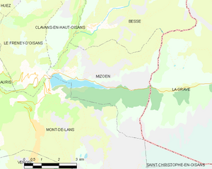
Mizoën
- commune in Isère, France
Hiking in Mizoën
Mizoën is a charming village located in the Écrins National Park in the French Alps. This picturesque region is known for its stunning landscapes, pristine wilderness, and variety of hiking trails suitable for all levels of experience. Here’s some information to help you plan your hiking adventure in Mizoën:...
- Country:
- Postal Code: 38142
- Coordinates: 45° 3' 0" N, 6° 8' 33" E
- GPS tracks (wikiloc): [Link]
- Area: 14.6 sq km
- Population: 195
- Web site: [Link]


Besse
- commune in Isère, France
Hiking in Besse
Besse, located in the Isère department of the Auvergne-Rhône-Alpes region in southeastern France, is a fantastic destination for hiking enthusiasts. Nestled in the spectacular landscapes of the French Alps, Besse offers a range of hiking trails that cater to various levels of experience, from beginner to expert....
- Country:
- Postal Code: 38142
- Coordinates: 45° 4' 18" N, 6° 10' 12" E
- GPS tracks (wikiloc): [Link]
- Area: 25.46 sq km
- Population: 133
- Web site: [Link]


Le Freney-d'Oisans
- commune in Isère, France
Hiking in Le Freney-d'Oisans
Le Freney-d'Oisans is a charming village located in the Auvergne-Rhône-Alpes region of France, nestled in the French Alps. It's a fantastic location for hiking enthusiasts due to its stunning natural scenery, diverse trails, and proximity to other outdoor activities....
- Country:
- Postal Code: 38142
- Coordinates: 45° 2' 41" N, 6° 7' 32" E
- GPS tracks (wikiloc): [Link]
- Area: 14.54 sq km
- Population: 252
- Web site: [Link]
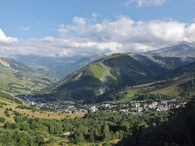

Saint-Sorlin-d'Arves
- commune in Savoie, France
Hiking in Saint-Sorlin-d'Arves
Saint-Sorlin-d'Arves is a beautiful alpine village located in the Savoie region of the French Alps. It is particularly known for its stunning landscapes, diverse wildlife, and a range of hiking trails that cater to various skill levels. Here’s a general overview of what you can expect when hiking in the area:...
- Country:
- Postal Code: 73530
- Coordinates: 45° 13' 16" N, 6° 14' 5" E
- GPS tracks (wikiloc): [Link]
- Area: 39 sq km
- Population: 339
- Web site: [Link]

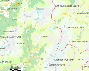
Vaujany
- commune in Isère, France
Hiking in Vaujany
Vaujany is a charming alpine village located in the French Alps, within the Oisans region, and is part of the larger Alpe d'Huez Grand Domaine Ski area. It's not only a great skiing destination but also an excellent location for hiking, especially during the warmer months when the snow melts and the trails become accessible....
- Country:
- Postal Code: 38114
- Coordinates: 45° 9' 27" N, 6° 4' 36" E
- GPS tracks (wikiloc): [Link]
- Area: 64.54 sq km
- Population: 307
- Web site: [Link]