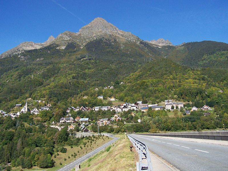
Vaujany (Vaujany)

- commune in Isère, France
 Hiking in Vaujany
Vaujany is a charming alpine village located in the French Alps, within the Oisans region, and is part of the larger Alpe d'Huez Grand Domaine Ski area. It's not only a great skiing destination but also an excellent location for hiking, especially during the warmer months when the snow melts and the trails become accessible.
Hiking in Vaujany:
-
Trail Variety: Vaujany offers a wide range of hiking trails that cater to different levels of expertise, from leisurely strolls to more challenging hikes. The terrain includes stunning alpine landscapes, lush pastures, and breathtaking views of the surrounding mountains.
-
Scenic Routes: Popular trails include routes that lead to scenic points like the Lake of Bissorte (Lac de Bissorte) and the waterfalls around the area. You can also explore the nearby mountains, such as the Grand Pic de Belledonne, which provides striking panoramas.
-
Marked Trails: Most hiking trails are well-marked and maintained, making it easier for hikers to navigate. Local maps and signage are available, often in English and French, which helps you plan your route effectively.
-
Wildlife and Flora: As you hike, keep an eye out for diverse alpine flora and fauna. The region is home to various species of wildflowers, mountain goats, and other wildlife, enhancing the hiking experience.
-
Guided Tours: If you are unfamiliar with the region or prefer to hike with a guide, various local companies offer guided hiking tours. These can provide insights into the local ecology, geography, and history.
-
Summer Events: In the summer months, Vaujany often hosts hiking events and festivals that celebrate the outdoor lifestyle, offering guided hikes, workshops, and opportunities to meet other hiking enthusiasts.
-
Facilities: The village has good amenities including restaurants, cafes, and accommodation options that make it a comfortable base for hikers.
Tips for Hiking in Vaujany:
- Check Weather Conditions: Always check the weather forecast before heading out, as alpine weather can change quickly.
- Pack Essentials: Bring plenty of water, snacks, sunscreen, and appropriate gear. Good hiking boots are essential, and consider layers for fluctuating temperatures.
- Plan Your Route: Familiarize yourself with the trail maps and choose routes that match your fitness level and experience.
- Respect Nature: Stick to marked trails, take your litter with you, and avoid disturbing wildlife.
Hiking in Vaujany offers a wonderful opportunity to explore the beauty of the French Alps while enjoying a range of outdoor activities and the fresh mountain air!
- Country:

- Postal Code: 38114
- Coordinates: 45° 9' 27" N, 6° 4' 36" E


- GPS tracks (wikiloc): [Link]
- Area: 64.54 sq km
- Population: 307
- Web site: http://www.vaujany.com
- Wikipedia en: wiki(en)
- Wikipedia: wiki(fr)
- Wikidata storage: Wikidata: Q1388437
- Wikipedia Commons Category: [Link]
- Freebase ID: [/m/03g_1nl]
- GeoNames ID: Alt: [2970470]
- SIREN number: [213805278]
- BnF ID: [152583271]
- PACTOLS thesaurus ID: [pcrtz3vfD6dfXV]
- Skimap area ID: [739]
- INSEE municipality code: 38527
Shares border with regions:


Clavans-en-Haut-Oisans
- commune in Isère, France
Hiking in Clavans-en-Haut-Oisans
Clavans-en-Haut-Oisans is a picturesque village located in the French Alps, specifically in the Isère department. It's a fantastic base for hiking enthusiasts due to its stunning natural surroundings and proximity to the Écrins National Park, one of France's largest and most beautiful national parks....
- Country:
- Postal Code: 38142
- Coordinates: 45° 5' 1" N, 6° 9' 46" E
- GPS tracks (wikiloc): [Link]
- Area: 15.58 sq km
- Population: 108
- Web site: [Link]

Allemond
- commune in Isère, France
Hiking in Allemond
Allemont is a picturesque village located in the French Alps, specifically in the Isère department. It serves as a gateway to the Vaujany valley and nearby hiking routes in the Oisans region, making it a great base for outdoor enthusiasts. Here are some highlights and considerations for hiking in and around Allemont:...
- Country:
- Postal Code: 38114
- Coordinates: 45° 7' 49" N, 6° 2' 15" E
- GPS tracks (wikiloc): [Link]
- Area: 44.75 sq km
- Population: 1006
- Web site: [Link]


La Ferrière
- commune in Isère, France
Hiking in La Ferrière
La Ferrière, located in the Isère department in France, is a charming village nestled in the French Alps. It offers a variety of hiking opportunities for both beginners and experienced hikers. The region is known for its stunning landscapes, featuring picturesque valleys, rugged mountain terrain, and lush forests....
- Country:
- Postal Code: 38580
- Coordinates: 45° 19' 11" N, 6° 5' 14" E
- GPS tracks (wikiloc): [Link]
- Area: 54.33 sq km
- Population: 231
- Web site: [Link]

Oz
- commune in Isère, France
Hiking in Oz
Hiking in Oz, a charming alpine village located in the Isère department of France, offers exhilarating experiences amidst breathtaking scenery. Situated within the Grandes Rousses mountains in the French Alps, Oz is part of the Alpe d'Huez ski area, which transforms into a hiker's paradise during the summer months....
- Country:
- Postal Code: 38114
- Coordinates: 45° 8' 27" N, 6° 3' 7" E
- GPS tracks (wikiloc): [Link]
- Area: 16.81 sq km
- Population: 246
- Web site: [Link]


Le Freney-d'Oisans
- commune in Isère, France
Hiking in Le Freney-d'Oisans
Le Freney-d'Oisans is a charming village located in the Auvergne-Rhône-Alpes region of France, nestled in the French Alps. It's a fantastic location for hiking enthusiasts due to its stunning natural scenery, diverse trails, and proximity to other outdoor activities....
- Country:
- Postal Code: 38142
- Coordinates: 45° 2' 41" N, 6° 7' 32" E
- GPS tracks (wikiloc): [Link]
- Area: 14.54 sq km
- Population: 252
- Web site: [Link]

Saint-Sorlin-d'Arves
- commune in Savoie, France
Hiking in Saint-Sorlin-d'Arves
Saint-Sorlin-d'Arves is a beautiful alpine village located in the Savoie region of the French Alps. It is particularly known for its stunning landscapes, diverse wildlife, and a range of hiking trails that cater to various skill levels. Here’s a general overview of what you can expect when hiking in the area:...
- Country:
- Postal Code: 73530
- Coordinates: 45° 13' 16" N, 6° 14' 5" E
- GPS tracks (wikiloc): [Link]
- Area: 39 sq km
- Population: 339
- Web site: [Link]


Saint-Colomban-des-Villards
- commune in Savoie, France
Hiking in Saint-Colomban-des-Villards
Saint-Colomban-des-Villards is a charming commune in the Savoie region of the French Alps, known for its stunning landscapes and diverse hiking opportunities. The area offers a mix of trails that cater to different skill levels, from leisurely walks to challenging hikes....
- Country:
- Postal Code: 73130
- Coordinates: 45° 17' 39" N, 6° 13' 36" E
- GPS tracks (wikiloc): [Link]
- AboveSeaLevel: 1204 м m
- Area: 81.12 sq km
- Population: 173