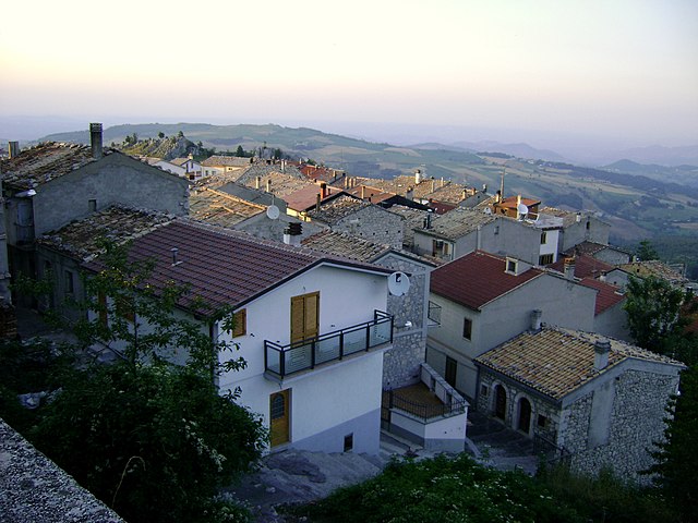
Colledimacine (Colledimacine)
.svg)
- Italian comune
 Hiking in Colledimacine
Colledimacine, located in the Abruzzo region of Italy, is a fantastic destination for hiking enthusiasts. Nestled within the Gran Sasso e Monti della Laga National Park, it offers breathtaking landscapes, diverse ecosystems, and a variety of hiking trails suitable for different skill levels.
Key Features of Hiking in Colledimacine:
-
Scenic Trails: The area boasts numerous hiking trails ranging from easy walks to more challenging treks. You can explore rocky terrains, lush forests, and panoramic viewpoints.
-
Natural Beauty: As you hike, you'll encounter stunning vistas of the surrounding mountains, valleys, and possibly some local wildlife. The region is known for its rich biodiversity, including unique flora and fauna.
-
Cultural Heritage: Colledimacine is also rich in history, with trails that may lead you to ancient ruins, traditional villages, and historic sites, allowing you to soak in both nature and culture during your hike.
-
Local Guides: Consider hiring a local guide who can provide insights into the area’s natural history, geology, and cultural significance. They can help navigate the trails and enhance your overall experience.
-
Best Seasons: The best time to hike in Colledimacine is typically in the spring (April to June) and fall (September to October) when the weather is milder, and the landscapes are particularly beautiful. Summer can be quite hot, while winter may bring snow, making some trails more challenging.
-
Preparation: Always check the weather conditions before heading out, wear appropriate footwear, and carry essentials like water, snacks, and a first aid kit. The terrain can be rugged, so having a good level of fitness is beneficial.
-
Respect Nature: Remember to follow Leave No Trace principles, ensuring you preserve the natural beauty of Colledimacine for future visitors.
Whether you are looking for a leisurely stroll or a more strenuous hike, Colledimacine has something to offer for everyone. Enjoy your adventure in this picturesque corner of Italy!
- Country:

- Postal Code: 66010
- Local Dialing Code: 0872
- Licence Plate Code: CH
- Coordinates: 42° 0' 0" N, 14° 12' 0" E


- GPS tracks (wikiloc): [Link]
- AboveSeaLevel: 770 м m
- Area: 11.3 sq km
- Population: 188
- Web site: http://www.comune.colledimacine.ch.it/
- Wikipedia en: wiki(en)
- Wikipedia: wiki(it)
- Wikidata storage: Wikidata: Q51208
- Wikipedia Commons Category: [Link]
- Freebase ID: [/m/0fg34l]
- GeoNames ID: Alt: [6537476]
- VIAF ID: Alt: [235710137]
- OSM relation ID: [41701]
- ISTAT ID: 069025
- Italian cadastre code: C855
Shares border with regions:


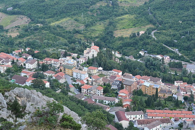
Lama dei Peligni
- Italian comune
Hiking in Lama dei Peligni
Lama dei Peligni is a picturesque village located in the mountains of the Abruzzo region in Italy. It's an excellent destination for hikers due to its stunning natural landscapes, varied terrain, and beautiful views of the surrounding Apennine mountains. Here are some highlights of hiking in this area:...
- Country:
- Postal Code: 66010
- Local Dialing Code: 0872
- Licence Plate Code: CH
- Coordinates: 42° 3' 0" N, 14° 11' 0" E
- GPS tracks (wikiloc): [Link]
- AboveSeaLevel: 669 м m
- Area: 31.37 sq km
- Population: 1200
- Web site: [Link]
Lettopalena
- Italian comune
Hiking in Lettopalena
Lettopalena is a charming village located in the Abruzzo region of Italy, surrounded by stunning natural landscapes, mountains, and historical sites. Hiking in and around Lettopalena offers a rich experience due to the diverse terrain, scenic views, and opportunities to explore the local flora and fauna....
- Country:
- Postal Code: 66010
- Local Dialing Code: 0872
- Licence Plate Code: CH
- Coordinates: 42° 0' 0" N, 14° 10' 0" E
- GPS tracks (wikiloc): [Link]
- AboveSeaLevel: 680 м m
- Area: 21.13 sq km
- Population: 339
- Web site: [Link]

Montenerodomo
- Italian comune
Hiking in Montenerodomo
Montenerodomo is a charming village located in the Abruzzo region of Italy, surrounded by stunning natural landscapes that are perfect for hiking enthusiasts. Here are some key points to consider if you're thinking about hiking in and around Montenerodomo:...
- Country:
- Postal Code: 66010
- Local Dialing Code: 0872
- Licence Plate Code: CH
- Coordinates: 41° 59' 0" N, 14° 15' 0" E
- GPS tracks (wikiloc): [Link]
- AboveSeaLevel: 1165 м m
- Area: 30 sq km
- Population: 656
- Web site: [Link]

Taranta Peligna
- Italian comune
Hiking in Taranta Peligna
Taranta Peligna is a quaint village located in the Abruzzo region of Italy, surrounded by stunning natural landscapes that make it a great destination for hiking enthusiasts. The area boasts a mix of rolling hills, mountainous terrain, and picturesque views, making it ideal for various hiking experiences....
- Country:
- Postal Code: 66018
- Local Dialing Code: 0872
- Licence Plate Code: CH
- Coordinates: 42° 1' 0" N, 14° 10' 0" E
- GPS tracks (wikiloc): [Link]
- AboveSeaLevel: 460 м m
- Area: 21.9 sq km
- Population: 353
- Web site: [Link]


Torricella Peligna
- Italian comune
Hiking in Torricella Peligna
Torricella Peligna is a picturesque village located in the Abruzzo region of Italy. Nestled in the Apennine Mountains, it is surrounded by stunning natural landscapes, making it an excellent destination for hiking enthusiasts. Here are some highlights and tips for hiking in Torricella Peligna:...
- Country:
- Postal Code: 66019
- Local Dialing Code: 0872
- Licence Plate Code: CH
- Coordinates: 42° 1' 0" N, 14° 16' 0" E
- GPS tracks (wikiloc): [Link]
- AboveSeaLevel: 910 м m
- Area: 36.11 sq km
- Population: 1292
- Web site: [Link]