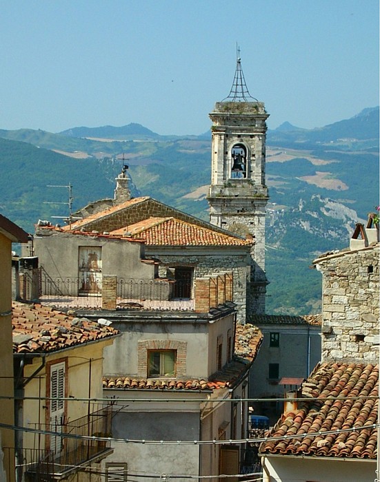
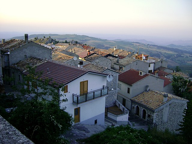
Torricella Peligna (Torricella Peligna)
.svg)
- Italian comune
 Hiking in Torricella Peligna
Torricella Peligna is a picturesque village located in the Abruzzo region of Italy. Nestled in the Apennine Mountains, it is surrounded by stunning natural landscapes, making it an excellent destination for hiking enthusiasts. Here are some highlights and tips for hiking in Torricella Peligna:
Hiking Trails
-
Majella National Park: Just a short distance from the village, this national park offers various trails that cater to different skill levels. The park is renowned for its rugged mountains, rich flora, and fauna, as well as its historical and archaeological sites.
-
The Parco della Maiella: This area features numerous marked trails that allow hikers to explore beautiful landscapes, including deep gorges, alpine meadows, and ancient hermitages. Popular paths include trails leading to the summits of Monte Amaro and Monte Focalone.
-
Local Trails: Torricella Peligna has its own set of trails that provide hikers with scenic views of the surrounding countryside and neighboring villages. These trails are often less crowded, allowing for a more serene hiking experience.
Difficulty Levels
The hiking trails around Torricella Peligna vary in difficulty. Beginners can find gentle walks that provide easy access to stunning lookout points, while experienced hikers can tackle more challenging routes with steep ascents and rugged terrain. It’s advisable to choose a trail that matches your skill level.
Best Time to Hike
The best time for hiking in this area is typically during spring (April to June) and fall (September to October), when the weather is mild, and the landscapes are especially beautiful. Summer can get quite warm, while winter may bring snow, impacting trail accessibility.
Safety Tips
- Stay Hydrated: Always carry enough water, especially on longer hikes.
- Dress Appropriately: Wear layered clothing and good hiking boots to accommodate changing weather conditions.
- Map and GPS: Carry a map or a GPS device, as some trails may not be well-marked.
- Tell Someone: Always inform someone of your hiking plans, especially if you’re heading out alone.
Local Culture
Aside from its natural beauty, Torricella Peligna is known for its rich cultural heritage. While hiking, take the time to explore the village, enjoy local cuisine, and experience the warm hospitality of its residents.
Whether you're looking for a serene nature escape or an adventurous hiking experience, Torricella Peligna provides a unique blend of both. Happy hiking!
- Country:

- Postal Code: 66019
- Local Dialing Code: 0872
- Licence Plate Code: CH
- Coordinates: 42° 1' 0" N, 14° 16' 0" E


- GPS tracks (wikiloc): [Link]
- AboveSeaLevel: 910 м m
- Area: 36.11 sq km
- Population: 1292
- Web site: http://www.comunetorricellapeligna.it/
- Wikipedia en: wiki(en)
- Wikipedia: wiki(it)
- Wikidata storage: Wikidata: Q51306
- Wikipedia Commons Category: [Link]
- Freebase ID: [/m/0fg3wm]
- GeoNames ID: Alt: [6541236]
- OSM relation ID: [41710]
- WOEID: [725138]
- DMOZ ID: Alt: [Regional/Europe/Italy/Abruzzo/Localities/Torricella_Peligna/]
- ISTAT ID: 069095
- Italian cadastre code: L291
Shares border with regions:

Bomba
- Italian comune
Hiking in Bomba
Bomba is a charming small town located in the province of Chieti in the Abruzzo region of Italy. Nestled within the foothills of the Appennine mountains and surrounded by stunning natural landscapes, it offers a variety of hiking opportunities for both beginners and experienced hikers....
- Country:
- Postal Code: 66042
- Local Dialing Code: 0872
- Licence Plate Code: CH
- Coordinates: 42° 2' 0" N, 14° 22' 0" E
- GPS tracks (wikiloc): [Link]
- AboveSeaLevel: 424 м m
- Area: 17.26 sq km
- Population: 785
- Web site: [Link]
Colledimacine
- Italian comune
Hiking in Colledimacine
Colledimacine, located in the Abruzzo region of Italy, is a fantastic destination for hiking enthusiasts. Nestled within the Gran Sasso e Monti della Laga National Park, it offers breathtaking landscapes, diverse ecosystems, and a variety of hiking trails suitable for different skill levels....
- Country:
- Postal Code: 66010
- Local Dialing Code: 0872
- Licence Plate Code: CH
- Coordinates: 42° 0' 0" N, 14° 12' 0" E
- GPS tracks (wikiloc): [Link]
- AboveSeaLevel: 770 м m
- Area: 11.3 sq km
- Population: 188
- Web site: [Link]


Gessopalena
- Italian comune
Hiking in Gessopalena
Gessopalena is a charming village located in the Abruzzo region of Italy, known for its stunning natural landscapes and outdoor activities, including hiking. The area offers a range of trails that cater to different skill levels, making it an excellent destination for both novice and experienced hikers....
- Country:
- Postal Code: 66010
- Local Dialing Code: 0872
- Licence Plate Code: CH
- Coordinates: 42° 3' 0" N, 14° 16' 0" E
- GPS tracks (wikiloc): [Link]
- AboveSeaLevel: 654 м m
- Area: 31.47 sq km
- Population: 1360
- Web site: [Link]


Lama dei Peligni
- Italian comune
Hiking in Lama dei Peligni
Lama dei Peligni is a picturesque village located in the mountains of the Abruzzo region in Italy. It's an excellent destination for hikers due to its stunning natural landscapes, varied terrain, and beautiful views of the surrounding Apennine mountains. Here are some highlights of hiking in this area:...
- Country:
- Postal Code: 66010
- Local Dialing Code: 0872
- Licence Plate Code: CH
- Coordinates: 42° 3' 0" N, 14° 11' 0" E
- GPS tracks (wikiloc): [Link]
- AboveSeaLevel: 669 м m
- Area: 31.37 sq km
- Population: 1200
- Web site: [Link]

Montenerodomo
- Italian comune
Hiking in Montenerodomo
Montenerodomo is a charming village located in the Abruzzo region of Italy, surrounded by stunning natural landscapes that are perfect for hiking enthusiasts. Here are some key points to consider if you're thinking about hiking in and around Montenerodomo:...
- Country:
- Postal Code: 66010
- Local Dialing Code: 0872
- Licence Plate Code: CH
- Coordinates: 41° 59' 0" N, 14° 15' 0" E
- GPS tracks (wikiloc): [Link]
- AboveSeaLevel: 1165 м m
- Area: 30 sq km
- Population: 656
- Web site: [Link]
Pennadomo
- Italian comune
Hiking in Pennadomo
Pennadomo, located in the Province of L'Aquila in the Abruzzo region of Italy, is a wonderful spot for hiking enthusiasts. The area is known for its stunning natural landscapes, including lush forests, rolling hills, and breathtaking views of the surrounding Apennine mountains....
- Country:
- Postal Code: 66040
- Local Dialing Code: 0872
- Licence Plate Code: CH
- Coordinates: 42° 0' 0" N, 14° 19' 0" E
- GPS tracks (wikiloc): [Link]
- AboveSeaLevel: 460 м m
- Area: 11.02 sq km
- Population: 251
- Web site: [Link]


Roccascalegna
- Italian comune
Hiking in Roccascalegna
Roccascalegna, a scenic village in the Abruzzo region of Italy, is renowned for its stunning landscapes, historical sites, and outdoor activities, making it a fantastic destination for hiking enthusiasts. Here’s some information that can help you plan your hiking experience:...
- Country:
- Postal Code: 66040
- Local Dialing Code: 0872
- Licence Plate Code: CH
- Coordinates: 42° 3' 44" N, 14° 18' 23" E
- GPS tracks (wikiloc): [Link]
- AboveSeaLevel: 430 м m
- Area: 23.01 sq km
- Population: 1172
- Web site: [Link]