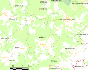
Concots (Concots)

- commune in Lot, France
- Country:

- Postal Code: 46260
- Coordinates: 44° 24' 6" N, 1° 38' 39" E


- GPS tracks (wikiloc): [Link]
- Area: 26.02 sq km
- Population: 419
- Wikipedia en: wiki(en)
- Wikipedia: wiki(fr)
- Wikidata storage: Wikidata: Q751957
- Wikipedia Commons Category: [Link]
- Freebase ID: [/m/03nwl4d]
- GeoNames ID: Alt: [6449235]
- SIREN number: [214600736]
- BnF ID: [15260814b]
- INSEE municipality code: 46073
Shares border with regions:
Berganty
- commune in Lot, France
- Country:
- Postal Code: 46090
- Coordinates: 44° 26' 37" N, 1° 38' 49" E
- GPS tracks (wikiloc): [Link]
- Area: 6.98 sq km
- Population: 111
Lugagnac
- commune in Lot, France
- Country:
- Postal Code: 46260
- Coordinates: 44° 24' 31" N, 1° 44' 9" E
- GPS tracks (wikiloc): [Link]
- Area: 15.81 sq km
- Population: 126


Escamps
- commune in Lot, France
- Country:
- Postal Code: 46230
- Coordinates: 44° 22' 0" N, 1° 38' 2" E
- GPS tracks (wikiloc): [Link]
- Area: 12.11 sq km
- Population: 201
- Web site: [Link]


Crégols
- commune in Lot, France
- Country:
- Postal Code: 46330
- Coordinates: 44° 27' 22" N, 1° 42' 3" E
- GPS tracks (wikiloc): [Link]
- Area: 18.35 sq km
- Population: 82

Varaire
- commune in Lot, France
- Country:
- Postal Code: 46260
- Coordinates: 44° 21' 28" N, 1° 43' 26" E
- GPS tracks (wikiloc): [Link]
- Area: 25.52 sq km
- Population: 311

Saint-Cirq-Lapopie
- commune in Lot, France
- Country:
- Postal Code: 46330
- Coordinates: 44° 27' 52" N, 1° 40' 11" E
- GPS tracks (wikiloc): [Link]
- Area: 17.89 sq km
- Population: 208


Esclauzels
- commune in Lot, France
- Country:
- Postal Code: 46090
- Coordinates: 44° 25' 18" N, 1° 37' 14" E
- GPS tracks (wikiloc): [Link]
- Area: 17.73 sq km
- Population: 224


Bach
- commune in Lot, France
- Country:
- Postal Code: 46230
- Coordinates: 44° 21' 1" N, 1° 40' 17" E
- GPS tracks (wikiloc): [Link]
- Area: 21.02 sq km
- Population: 175
Cremps
- commune in Lot, France
- Country:
- Postal Code: 46230
- Coordinates: 44° 23' 20" N, 1° 36' 0" E
- GPS tracks (wikiloc): [Link]
- Area: 19.66 sq km
- Population: 364
- Web site: [Link]