Cornillon-en-Trièves (Cornillon-en-Trièves)
- commune in Isère, France
 Hiking in Cornillon-en-Trièves
Cornillon-en-Trièves is a charming village located in the Trièves region of the French Alps, in the department of Isère. It offers a range of hiking opportunities that showcase the stunning natural beauty of the surrounding landscape, including mountains, forests, and picturesque views of the surrounding valleys.
Hiking Highlights in Cornillon-en-Trièves:
-
Scenic Trails: The area around Cornillon-en-Trièves features a variety of marked trails of differing difficulty levels. Many trails offer opportunities for tranquil walks through lush landscapes, as well as more challenging routes for seasoned hikers.
-
Panoramic Views: Many hikes in the area provide stunning views of the Trièves plateau and the surrounding mountains, including the Vercors massif. The views are particularly spectacular during sunrise or sunset.
-
Access to Natural Parks: The village is close to both the Vercors Natural Regional Park and the Ecrins National Park, which offer extensive hiking paths, including routes that can lead to alpine lakes and high-altitude trails. You can easily venture into these larger protected areas for a more immersive outdoor experience.
-
Flora and Fauna: As you hike, keep an eye out for the diverse plants and wildlife native to the region. The combination of altitude and varied ecosystems makes it a great place for nature enthusiasts.
-
Local Culture: Hiking in Cornillon-en-Trièves also offers a chance to experience local culture. You might encounter farmhouses, traditional architecture, and areas where local agricultural practices are evident. Engaging with locals can provide insights into the history and traditions of the region.
Recommended Hikes:
- Barrage de Monteynard: This hike offers vistas over the reservoir and plenty of opportunities for photography.
- La Roche de la Fare: A popular route that provides breathtaking panoramic views, ideal for more experienced hikers looking for a challenge.
- Countryside Walks: There are gentler routes available suitable for families or those looking for a more relaxed outing.
Tips for Hiking in Cornillon-en-Trièves:
- Weather Check: Always check the weather before heading out, as conditions can change rapidly in mountainous regions.
- Pack Appropriately: Bring enough water, snacks, and proper hiking gear, including good shoes and layers of clothing.
- Respect Nature: Follow the Leave No Trace principles to help preserve the natural beauty of the area.
Whether you're an experienced hiker or just looking for a peaceful walk in nature, Cornillon-en-Trièves is a wonderful destination with plenty to offer. Enjoy your hiking adventure!
- Country:

- Postal Code: 38710
- Coordinates: 44° 49' 46" N, 5° 43' 3" E


- GPS tracks (wikiloc): [Link]
- Area: 13.92 sq km
- Population: 169
- Wikipedia en: wiki(en)
- Wikipedia: wiki(fr)
- Wikidata storage: Wikidata: Q1075689
- Wikipedia Commons Category: [Link]
- Freebase ID: [/m/03g_4y4]
- GeoNames ID: Alt: [3023575]
- SIREN number: [213801277]
- BnF ID: [15257950z]
- INSEE municipality code: 38127
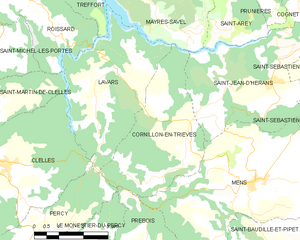
Shares border with regions:


Percy
- commune in Isère, France
Hiking in Percy, Isère, is a wonderful experience for outdoor enthusiasts, as it offers access to breathtaking landscapes and a variety of trails suitable for different skill levels. Located in the Auvergne-Rhône-Alpes region of France, Percy is surrounded by the stunning natural beauty of the Vercors massif and the Chartreuse mountains....
- Country:

- Postal Code: 38930
- Coordinates: 44° 48' 5" N, 5° 38' 59" E


- GPS tracks (wikiloc): [Link]
- Area: 15.93 sq km
- Population: 165
- Web site: [Link]


Saint-Jean-d'Hérans
- commune in Isère, France
Saint-Jean-d'Hérans is a picturesque village located in the Isère department of the Auvergne-Rhône-Alpes region in southeastern France. It offers beautiful hiking opportunities set against the backdrop of stunning natural landscapes, including mountains, forests, and rivers....
- Country:

- Postal Code: 38710
- Coordinates: 44° 51' 12" N, 5° 45' 39" E


- GPS tracks (wikiloc): [Link]
- Area: 17.48 sq km
- Population: 295


Prébois
- commune in Isère, France
Prébois is a scenic area located in the French Alps, known for its stunning landscapes, diverse flora and fauna, and hiking opportunities. Here are some key points to consider if you're planning a hike in Prébois:...
- Country:

- Postal Code: 38710
- Coordinates: 44° 47' 22" N, 5° 41' 42" E


- GPS tracks (wikiloc): [Link]
- Area: 16.03 sq km
- Population: 165
- Web site: [Link]


Mayres-Savel
- commune in Isère, France
Mayres-Savel, located in the Auvergne-Rhône-Alpes region of France, offers a variety of hiking opportunities that showcase its stunning natural beauty. The region is characterized by rugged landscapes, lush forests, and breathtaking vistas, making it an excellent destination for outdoor enthusiasts....
- Country:

- Postal Code: 38350
- Coordinates: 44° 52' 28" N, 5° 43' 19" E


- GPS tracks (wikiloc): [Link]
- Area: 12.51 sq km
- Population: 119
- Web site: [Link]


Lavars
- commune in Isère, France
Lavars is a small village located in the Auvergne-Rhône-Alpes region of France, known for its beautiful natural surroundings and potential hiking opportunities. While Lavars itself may not have extensive trails, it serves as a good base for exploring the surrounding areas, particularly the Vercors Regional Natural Park and the Chartreuse Mountains which are within a reasonable distance....
- Country:

- Postal Code: 38710
- Coordinates: 44° 50' 56" N, 5° 40' 21" E


- GPS tracks (wikiloc): [Link]
- Area: 14.8 sq km
- Population: 149


Mens
- commune in Isère, France
Hiking in the Vercors region of Isère, particularly around Mens, offers a fantastic blend of natural beauty, diverse terrain, and rich cultural heritage. Here are some highlights and tips for hiking in the area:...
- Country:

- Postal Code: 38710
- Coordinates: 44° 49' 1" N, 5° 45' 1" E


- GPS tracks (wikiloc): [Link]
- Area: 28.29 sq km
- Population: 1379
- Web site: [Link]
