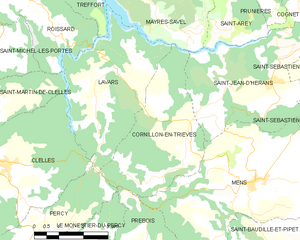
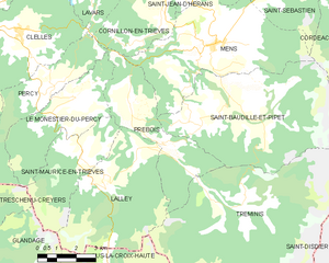
canton of Mens (canton de Mens)
- canton of France (until March 2015)
Canton de Mens, located in the Isère department of the Auvergne-Rhône-Alpes region in southeastern France, offers a beautiful landscape for hiking enthusiasts. This area is characterized by its mountainous terrain, picturesque valleys, and rich biodiversity, making it an ideal spot for both casual walkers and experienced trekkers.
Key Features of Hiking in Canton de Mens:
-
Scenic Trails: The region has a variety of hiking trails ranging from beginner to advanced levels. You can enjoy stunning views of the surrounding mountains, valleys, and alpine meadows. The trails often lead through lush forests and past crystal-clear streams.
-
Natural Parks: The Canton de Mens is close to several natural parks, including the Écrins National Park and the Vercors Regional Natural Park. These parks are home to diverse flora and fauna, with opportunities to spot wildlife such as chamois, deer, and various bird species.
-
Culturally Rich: As you hike, you’ll come across traditional mountain villages and historical sites that offer a glimpse into the local culture and history. It’s a great way to combine nature with cultural exploration.
-
Seasonal Hiking: Depending on the season, hiking experiences can vary greatly. Spring brings blossoming flowers and mild temperatures, summer offers lush greenery and vibrant views, autumn showcases stunning fall foliage, and winter can turn trails into snow-covered wonderlands for snowshoeing or winter hiking.
-
Local Advice: Make sure to check local resources for trail maps and current hiking conditions. Engaging with local tourist offices can provide valuable insights and recommendations for guided hikes or popular routes.
-
Safety Considerations: Always be prepared with appropriate gear, plenty of water, and check weather conditions before heading out. Some trails can be steep and rugged, so a good pair of hiking boots and proper clothing are essential.
-
Accessibility: The region is accessible by car, and there are public transport options available from major towns, but having a personal vehicle could offer more convenience for reaching trailheads.
Popular Hiking Routes:
- Les Crêts: A family-friendly trail that offers lovely views and is perfect for a day hike.
- Le sentier des plaines: This trail is great for those seeking a more leisurely walk through stunning landscapes.
- Higher routes: For seasoned hikers, consider exploring higher elevation paths that may lead to panoramic views of the surrounding Alps.
Conclusion:
Canton de Mens is a hidden gem for hikers, providing a mix of natural beauty, adventure, and cultural experiences. Whether you're looking for a short walk or an extended trek, you’ll find plenty of options to enjoy the fresh mountain air and breathtaking scenery. Happy hiking!
- Country:

- Capital: Mens
- Coordinates: 44° 49' 1" N, 5° 45' 6" E


- GPS tracks (wikiloc): [Link]
- Wikidata storage: Wikidata: Q1525756
- INSEE canton code: [3816]
Includes regions:


Cordéac
- former commune in Isère, France
Cordéac is a small village located in the French Alps, offering stunning natural landscapes ideal for hiking. The region is well-suited for both experienced hikers and those looking for gentler trails. Here are some highlights to consider when hiking in Cordéac:...
- Country:

- Postal Code: 38710
- Coordinates: 44° 49' 38" N, 5° 50' 17" E


- GPS tracks (wikiloc): [Link]
- Area: 26.62 sq km
- Population: 200


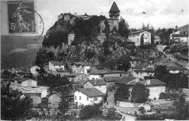
Cornillon-en-Trièves
- commune in Isère, France
 Hiking in Cornillon-en-Trièves
Cornillon-en-Trièves is a charming village located in the Trièves region of the French Alps, in the department of Isère. It offers a range of hiking opportunities that showcase the stunning natural beauty of the surrounding landscape, including mountains, forests, and picturesque views of the surrounding valleys....
- Country:

- Postal Code: 38710
- Coordinates: 44° 49' 46" N, 5° 43' 3" E


- GPS tracks (wikiloc): [Link]
- Area: 13.92 sq km
- Population: 169


Saint-Jean-d'Hérans
- commune in Isère, France
Saint-Jean-d'Hérans is a picturesque village located in the Isère department of the Auvergne-Rhône-Alpes region in southeastern France. It offers beautiful hiking opportunities set against the backdrop of stunning natural landscapes, including mountains, forests, and rivers....
- Country:

- Postal Code: 38710
- Coordinates: 44° 51' 12" N, 5° 45' 39" E


- GPS tracks (wikiloc): [Link]
- Area: 17.48 sq km
- Population: 295


Saint-Baudille-et-Pipet
- commune in Isère, France
 Hiking in Saint-Baudille-et-Pipet
Saint-Baudille-et-Pipet is a charming commune located in the Auvergne-Rhône-Alpes region of France, surrounded by beautiful natural landscapes that are perfect for hiking enthusiasts. The area offers a variety of trails that cater to different skill levels, making it an excellent destination for both novices and experienced hikers....
- Country:

- Postal Code: 38710
- Coordinates: 44° 47' 3" N, 5° 46' 7" E


- GPS tracks (wikiloc): [Link]
- Area: 35.97 sq km
- Population: 257


Prébois
- commune in Isère, France
Prébois is a scenic area located in the French Alps, known for its stunning landscapes, diverse flora and fauna, and hiking opportunities. Here are some key points to consider if you're planning a hike in Prébois:...
- Country:

- Postal Code: 38710
- Coordinates: 44° 47' 22" N, 5° 41' 42" E


- GPS tracks (wikiloc): [Link]
- Area: 16.03 sq km
- Population: 165
- Web site: [Link]


Saint-Sébastien
- former commune in Isère, France
Saint-Sébastien is a charming commune in the Isère department of the Auvergne-Rhône-Alpes region in France. The area is known for its beautiful mountain landscapes, making it an excellent destination for hiking enthusiasts. Here are some insights into hiking in and around Saint-Sébastien:...
- Country:

- Postal Code: 38710
- Coordinates: 44° 50' 50" N, 5° 47' 57" E


- GPS tracks (wikiloc): [Link]
- Area: 20.98 sq km
- Population: 259
- Web site: [Link]


Lavars
- commune in Isère, France
Lavars is a small village located in the Auvergne-Rhône-Alpes region of France, known for its beautiful natural surroundings and potential hiking opportunities. While Lavars itself may not have extensive trails, it serves as a good base for exploring the surrounding areas, particularly the Vercors Regional Natural Park and the Chartreuse Mountains which are within a reasonable distance....
- Country:

- Postal Code: 38710
- Coordinates: 44° 50' 56" N, 5° 40' 21" E


- GPS tracks (wikiloc): [Link]
- Area: 14.8 sq km
- Population: 149


Mens
- commune in Isère, France
Hiking in the Vercors region of Isère, particularly around Mens, offers a fantastic blend of natural beauty, diverse terrain, and rich cultural heritage. Here are some highlights and tips for hiking in the area:...
- Country:

- Postal Code: 38710
- Coordinates: 44° 49' 1" N, 5° 45' 1" E


- GPS tracks (wikiloc): [Link]
- Area: 28.29 sq km
- Population: 1379
- Web site: [Link]


Tréminis
- commune in Isère, France
Tréminis is a charming village located in the Isère department of the Auvergne-Rhône-Alpes region in southeastern France. It’s known for its beautiful landscapes and outdoor activities, making it a great spot for hiking enthusiasts....
- Country:

- Postal Code: 38710
- Coordinates: 44° 44' 51" N, 5° 46' 8" E


- GPS tracks (wikiloc): [Link]
- Area: 49.4 sq km
- Population: 180