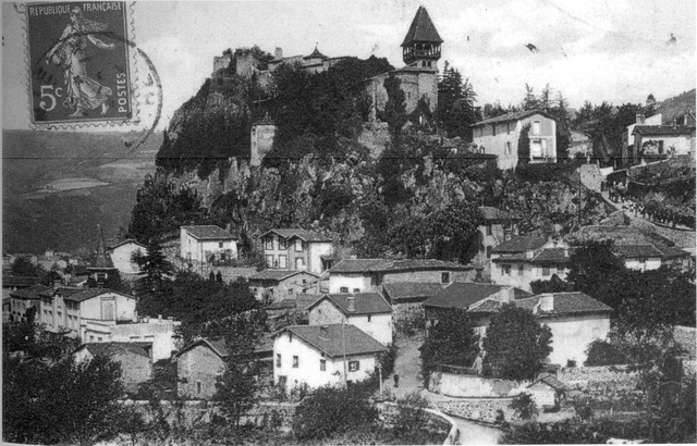
Prébois (Prébois)

- commune in Isère, France
 Hiking in Prébois
Prébois is a scenic area located in the French Alps, known for its stunning landscapes, diverse flora and fauna, and hiking opportunities. Here are some key points to consider if you're planning a hike in Prébois:
Trails
- Variety of Trails: There are numerous trails ranging from easy walks suitable for families to more challenging routes for experienced hikers. Make sure to choose a trail that matches your fitness level and experience.
- Marked Paths: Most hikes are well-marked, but it’s always a good idea to carry a map or GPS device, especially if you’re venturing off the main paths.
Scenery
- Stunning Views: The region offers breathtaking views of the surrounding peaks, valleys, and forests. Don’t forget to bring your camera!
- Wildlife Watching: Keep an eye out for the local wildlife, including mountain goats, deer, and various bird species.
Safety Tips
- Check Weather Conditions: The weather can change rapidly in the mountains, so always check forecasts before heading out. Dress in layers and be prepared for sudden changes.
- Stay Hydrated and Fueled: Bring enough water and snacks to keep your energy levels up throughout the hike.
- Tell Someone Your Plans: Always inform someone about your hiking plans and expected return time, especially when hiking in less populated areas.
Best Time to Visit
- Summer and Early Fall: The best time for hiking in Prébois is typically from late spring to early fall, when the trails are clear of snow and wildflowers are in bloom.
Local Regulations
- Respect Nature: Adhere to local guidelines regarding wildlife protection and trail use. Stay on marked paths to minimize environmental impact and preserve the area’s beauty.
Accessibility
- Getting There: Prébois can be accessed from several nearby towns. Ensure you have adequate transportation to your starting point.
Whether you're looking for a peaceful walk through nature or an adventurous climb, Prébois offers a fantastic experience for hikers. Enjoy your adventure, and remember to leave no trace!
- Country:

- Postal Code: 38710
- Coordinates: 44° 47' 22" N, 5° 41' 42" E


- GPS tracks (wikiloc): [Link]
- Area: 16.03 sq km
- Population: 165
- Web site: http://prebois.net/
- Wikipedia en: wiki(en)
- Wikipedia: wiki(fr)
- Wikidata storage: Wikidata: Q1151398
- Wikipedia Commons Category: [Link]
- Freebase ID: [/m/03g_4xt]
- GeoNames ID: Alt: [6433295]
- SIREN number: [213803216]
- BnF ID: [15258133d]
- INSEE municipality code: 38321
Shares border with regions:
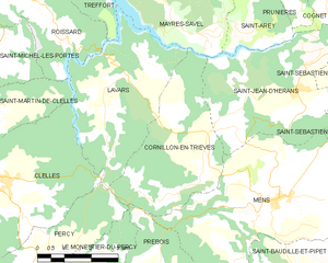
Cornillon-en-Trièves
- commune in Isère, France
Hiking in Cornillon-en-Trièves
Cornillon-en-Trièves is a charming village located in the Trièves region of the French Alps, in the department of Isère. It offers a range of hiking opportunities that showcase the stunning natural beauty of the surrounding landscape, including mountains, forests, and picturesque views of the surrounding valleys....
- Country:
- Postal Code: 38710
- Coordinates: 44° 49' 46" N, 5° 43' 3" E
- GPS tracks (wikiloc): [Link]
- Area: 13.92 sq km
- Population: 169


Le Monestier-du-Percy
- commune in Isère, France
Hiking in Le Monestier-du-Percy
Le Monestier-du-Percy is a picturesque commune located in the Isère department of the Auvergne-Rhône-Alpes region in southeastern France. It's a fantastic destination for hiking enthusiasts, offering a mix of serene landscapes, lush forests, and stunning mountain vistas....
- Country:
- Postal Code: 38930
- Coordinates: 44° 47' 39" N, 5° 39' 32" E
- GPS tracks (wikiloc): [Link]
- Area: 14.99 sq km
- Population: 249
- Web site: [Link]


Percy
- commune in Isère, France
Hiking in Percy
Hiking in Percy, Isère, is a wonderful experience for outdoor enthusiasts, as it offers access to breathtaking landscapes and a variety of trails suitable for different skill levels. Located in the Auvergne-Rhône-Alpes region of France, Percy is surrounded by the stunning natural beauty of the Vercors massif and the Chartreuse mountains....
- Country:
- Postal Code: 38930
- Coordinates: 44° 48' 5" N, 5° 38' 59" E
- GPS tracks (wikiloc): [Link]
- Area: 15.93 sq km
- Population: 165
- Web site: [Link]


Saint-Maurice-en-Trièves
- commune in Isère, France
Hiking in Saint-Maurice-en-Trièves
Saint-Maurice-en-Trièves is a charming village nestled in the Trièves region of the French Alps, known for its stunning natural landscapes, diverse wildlife, and a variety of hiking opportunities. Here are some key points to consider if you're planning a hiking trip in this area:...
- Country:
- Postal Code: 38930
- Coordinates: 44° 45' 52" N, 5° 39' 50" E
- GPS tracks (wikiloc): [Link]
- Area: 12.94 sq km
- Population: 156


Saint-Baudille-et-Pipet
- commune in Isère, France
Hiking in Saint-Baudille-et-Pipet
Saint-Baudille-et-Pipet is a charming commune located in the Auvergne-Rhône-Alpes region of France, surrounded by beautiful natural landscapes that are perfect for hiking enthusiasts. The area offers a variety of trails that cater to different skill levels, making it an excellent destination for both novices and experienced hikers....
- Country:
- Postal Code: 38710
- Coordinates: 44° 47' 3" N, 5° 46' 7" E
- GPS tracks (wikiloc): [Link]
- Area: 35.97 sq km
- Population: 257


Lalley
- commune in Isère, France
Hiking in Lalley
Lalley, located in the northern part of the United States, specifically in New Hampshire's White Mountains, offers a variety of hiking opportunities for all skill levels. The area is known for its stunning natural beauty, including dense forests, mountain streams, and panoramic views. Here are some highlights of hiking in Lalley:...
- Country:
- Postal Code: 38930
- Coordinates: 44° 45' 28" N, 5° 40' 34" E
- GPS tracks (wikiloc): [Link]
- Area: 23.65 sq km
- Population: 201
- Web site: [Link]


Mens
- commune in Isère, France
Hiking in Mens
Hiking in the Vercors region of Isère, particularly around Mens, offers a fantastic blend of natural beauty, diverse terrain, and rich cultural heritage. Here are some highlights and tips for hiking in the area:...
- Country:
- Postal Code: 38710
- Coordinates: 44° 49' 1" N, 5° 45' 1" E
- GPS tracks (wikiloc): [Link]
- Area: 28.29 sq km
- Population: 1379
- Web site: [Link]


Tréminis
- commune in Isère, France
Hiking in Tréminis
Tréminis is a charming village located in the Isère department of the Auvergne-Rhône-Alpes region in southeastern France. It’s known for its beautiful landscapes and outdoor activities, making it a great spot for hiking enthusiasts....
- Country:
- Postal Code: 38710
- Coordinates: 44° 44' 51" N, 5° 46' 8" E
- GPS tracks (wikiloc): [Link]
- Area: 49.4 sq km
- Population: 180