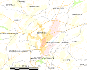
Coutances (Coutances)
- commune in Manche, France
- Country:

- Postal Code: 50200
- Coordinates: 49° 3' 0" N, 1° 26' 0" E


- GPS tracks (wikiloc): [Link]
- AboveSeaLevel: 92 м m
- Area: 12.51 sq km
- Population: 8688
- Web site: http://www.ville-coutances.fr
- Wikipedia en: wiki(en)
- Wikipedia: wiki(fr)
- Wikidata storage: Wikidata: Q202565
- Wikipedia Commons Category: [Link]
- Freebase ID: [/m/03zswk]
- Freebase ID: [/m/03zswk]
- GeoNames ID: Alt: [3022826]
- GeoNames ID: Alt: [3022826]
- SIREN number: [215001470]
- SIREN number: [215001470]
- BnF ID: [152621246]
- BnF ID: [152621246]
- VIAF ID: Alt: [136039455]
- VIAF ID: Alt: [136039455]
- GND ID: Alt: [4085350-0]
- GND ID: Alt: [4085350-0]
- archINFORM location ID: [12467]
- archINFORM location ID: [12467]
- Library of Congress authority ID: Alt: [n80065056]
- Library of Congress authority ID: Alt: [n80065056]
- PACTOLS thesaurus ID: [pcrttSt7duec0r]
- PACTOLS thesaurus ID: [pcrttSt7duec0r]
- Encyclopædia Britannica Online ID: [place/Coutances]
- Encyclopædia Britannica Online ID: [place/Coutances]
- Great Russian Encyclopedia Online ID: [2123748]
- Great Russian Encyclopedia Online ID: [2123748]
- Digital Atlas of the Roman Empire ID: [134]
- Digital Atlas of the Roman Empire ID: [134]
- INSEE municipality code: 50147
- INSEE municipality code: 50147
- US National Archives Identifier: 10045012
- US National Archives Identifier: 10045012
Shares border with regions:


Monthuchon
- commune in Manche, France
- Country:

- Postal Code: 50200
- Coordinates: 49° 4' 56" N, 1° 25' 19" E


- GPS tracks (wikiloc): [Link]
- Area: 7.66 sq km
- Population: 651


Bricqueville-la-Blouette
- commune in Manche, France
- Country:

- Postal Code: 50200
- Coordinates: 49° 2' 3" N, 1° 28' 43" E


- GPS tracks (wikiloc): [Link]
- Area: 6.25 sq km
- Population: 561
- Web site: [Link]


Gratot
- commune in Manche, France
- Country:

- Postal Code: 50200
- Coordinates: 49° 4' 7" N, 1° 29' 45" E


- GPS tracks (wikiloc): [Link]
- Area: 10.73 sq km
- Population: 646
- Web site: [Link]


Cambernon
- commune in Manche, France
- Country:

- Postal Code: 50200
- Coordinates: 49° 4' 49" N, 1° 23' 8" E


- GPS tracks (wikiloc): [Link]
- Area: 17.01 sq km
- Population: 733
- Web site: [Link]


Nicorps
- commune in Manche, France
- Country:

- Postal Code: 50200
- Coordinates: 49° 1' 37" N, 1° 25' 15" E


- GPS tracks (wikiloc): [Link]
- Area: 5.63 sq km
- Population: 418


Courcy
- commune in Manche, France
- Country:

- Postal Code: 50200
- Coordinates: 49° 2' 29" N, 1° 23' 35" E


- GPS tracks (wikiloc): [Link]
- Area: 11.45 sq km
- Population: 618


Saint-Pierre-de-Coutances
- commune in Manche, France
- Country:

- Postal Code: 50200
- Coordinates: 49° 2' 9" N, 1° 26' 57" E


- GPS tracks (wikiloc): [Link]
- AboveSeaLevel: 47 м m
- Area: 4.04 sq km
- Population: 422
