Dieuze (Dieuze)
- commune in Moselle, France
- Country:

- Postal Code: 57260
- Coordinates: 48° 48' 44" N, 6° 43' 11" E


- GPS tracks (wikiloc): [Link]
- AboveSeaLevel: 219 м m
- Area: 9.35 sq km
- Population: 3093
- Web site: http://www.mairie-dieuze.fr/
- Wikipedia en: wiki(en)
- Wikipedia: wiki(fr)
- Wikidata storage: Wikidata: Q22695
- Wikipedia Commons Category: [Link]
- Freebase ID: [/m/07yyms]
- Freebase ID: [/m/07yyms]
- GeoNames ID: Alt: [3021392]
- GeoNames ID: Alt: [3021392]
- SIREN number: [215701772]
- SIREN number: [215701772]
- BnF ID: [15265685h]
- BnF ID: [15265685h]
- VIAF ID: Alt: [142061422]
- VIAF ID: Alt: [142061422]
- GND ID: Alt: [4393930-2]
- GND ID: Alt: [4393930-2]
- Library of Congress authority ID: Alt: [n96025848]
- Library of Congress authority ID: Alt: [n96025848]
- MusicBrainz area ID: [0ab8c165-740e-481c-9542-e0cefe1cb63b]
- MusicBrainz area ID: [0ab8c165-740e-481c-9542-e0cefe1cb63b]
- Global Anabaptist Mennonite Encyclopedia Online ID: [Dieuze (Lorraine, France)]
- Global Anabaptist Mennonite Encyclopedia Online ID: [Dieuze (Lorraine, France)]
- INSEE municipality code: 57177
- INSEE municipality code: 57177
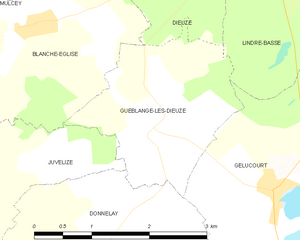
Shares border with regions:


Val-de-Bride
- commune in Moselle, France
- Country:

- Postal Code: 57260
- Coordinates: 48° 49' 31" N, 6° 41' 52" E


- GPS tracks (wikiloc): [Link]
- AboveSeaLevel: 220 м m
- Area: 11.12 sq km
- Population: 595


Guébestroff
- commune in Moselle, France
- Country:

- Postal Code: 57260
- Coordinates: 48° 49' 51" N, 6° 43' 8" E


- GPS tracks (wikiloc): [Link]
- Area: 3.81 sq km
- Population: 46


Lindre-Haute
- commune in Moselle, France
- Country:

- Postal Code: 57260
- Coordinates: 48° 48' 49" N, 6° 45' 2" E


- GPS tracks (wikiloc): [Link]
- Area: 2.46 sq km
- Population: 44


Guéblange-lès-Dieuze
- commune in Moselle, France
- Country:

- Postal Code: 57260
- Coordinates: 48° 46' 30" N, 6° 42' 1" E


- GPS tracks (wikiloc): [Link]
- Area: 4.89 sq km
- Population: 170


Lindre-Basse
- commune in Moselle, France
- Country:

- Postal Code: 57260
- Coordinates: 48° 48' 8" N, 6° 44' 51" E


- GPS tracks (wikiloc): [Link]
- Area: 8.28 sq km
- Population: 229


Vergaville
- commune in Moselle, France
- Country:

- Postal Code: 57260
- Coordinates: 48° 50' 14" N, 6° 44' 38" E


- GPS tracks (wikiloc): [Link]
- Area: 13.17 sq km
- Population: 593


Blanche-Église
- commune in Moselle, France
- Country:

- Postal Code: 57260
- Coordinates: 48° 47' 30" N, 6° 40' 23" E


- GPS tracks (wikiloc): [Link]
- Area: 6.89 sq km
- Population: 118
