Rhäzüns (Rhäzüns)

- municipality in Switzerland
 Hiking in Rhäzüns
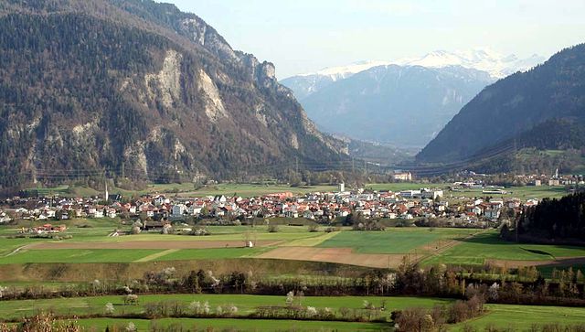
Rhäzüns is a beautiful municipality located in the Graubünden region of Switzerland, surrounded by stunning landscapes and offering excellent hiking opportunities. The area is characterized by its picturesque mountains, dense forests, and lovely meadows, making it a fantastic destination for outdoor enthusiasts.
Hiking Trails
-
Rhäzüns - Chur Loop: This is a popular trail that connects Rhäzüns with the nearby city of Chur. The route offers a mix of forest paths and open areas with panoramic views of the surrounding Alps. It's a moderate hike suitable for most levels.
-
Hiking to the Rappenflue: For those seeking a more challenging hike, the trail to Rappenflue provides an exciting climb with breathtaking views once you reach the summit. The trail is well-marked, but hikers should be prepared for steeper sections.
-
Via Alpina: Part of the famous long-distance hiking trail that crosses the entire Swiss Alps, sections of this trail pass near Rhäzüns. It's a wonderful option for hikers looking for a multi-day trek, as there are numerous accommodations along the route.
Seasonality
- Summer: The summer months are fantastic for hiking, as the trails are typically clear of snow and the weather is generally pleasant.
- Autumn: Fall brings vibrant foliage, making hikes particularly scenic.
- Winter: While not ideal for regular hiking, some trails may offer snowshoeing options. Always check local conditions and seek guidance if you're venturing out in winter.
Preparation
- Trail Maps: Make sure to carry updated trail maps or a GPS device to navigate the trails easily.
- Footwear: Good hiking boots are essential, especially for steeper or rocky paths.
- Weather: Conditions can change rapidly in the mountains, so check forecasts and dress in layers.
- Water and Snacks: Always carry enough water and snacks to keep your energy levels up during hikes.
Local Amenities
Rhäzüns offers facilities such as restaurants, accommodation options, and local shops. This makes it a convenient base for hikers looking to explore the region.
Tips for Hikers
- Respect the environment: Stay on marked trails and leave no trace.
- Inform someone about your hiking plans, especially for longer hikes.
- Consider hiking with a partner or group for safety.
Whether you're looking for a relaxed day hike or a more rigorous mountain challenge, Rhäzüns has something to offer for every hiker!
- Country:

- Postal Code: 7403
- Local Dialing Code: 081
- Licence Plate Code: GR
- Coordinates: 46° 47' 59" N, 9° 23' 59" E


- GPS tracks (wikiloc): [Link]
- AboveSeaLevel: 657 м m
- Area: 13.37 sq km
- Population: 1494
- Web site: http://www.rhaezuens.ch
- Wikipedia en: wiki(en)
- Wikipedia: wiki(de)
- Wikidata storage: Wikidata: Q66030
- Wikipedia Commons Category: [Link]
- Freebase ID: [/m/0frnv8]
- GeoNames ID: Alt: [2659064]
- VIAF ID: Alt: [150080523]
- OSM relation ID: [1684135]
- Library of Congress authority ID: Alt: [n79013794]
- HDS ID: [1515]
- Swiss municipality code: [3723]
Shares border with regions:


Cazis
- municipality in Switzerland
Hiking in Cazis
Cazis, located in the beautiful canton of Graubünden in Switzerland, is a fantastic destination for hiking enthusiasts. The region is known for its stunning Alpine scenery, charming villages, and well-maintained hiking trails. Here are some key highlights about hiking in Cazis:...
- Country:
- Postal Code: 7408
- Local Dialing Code: 081
- Licence Plate Code: GR
- Coordinates: 46° 44' 14" N, 9° 25' 36" E
- GPS tracks (wikiloc): [Link]
- AboveSeaLevel: 633 м m
- Area: 31.18 sq km
- Population: 2174
- Web site: [Link]

Bonaduz
- municipality in Switzerland
Hiking in Bonaduz
Bonaduz, located in the Grisons region of Switzerland, is an excellent destination for hiking enthusiasts. The area is characterized by its stunning natural landscapes, including the surrounding mountains, lush forests, and scenic rivers....
- Country:
- Postal Code: 7402
- Local Dialing Code: 081
- Licence Plate Code: GR
- Coordinates: 46° 48' 19" N, 9° 22' 15" E
- GPS tracks (wikiloc): [Link]
- AboveSeaLevel: 743 м m
- Area: 14.40 sq km
- Population: 3294
- Web site: [Link]


Rothenbrunnen
- municipality of Switzerland
Hiking in Rothenbrunnen
Rothenbrunnen is a picturesque village situated in the beautiful Surselva region of Switzerland, known for its stunning landscapes, dramatic cliffs, and diverse hiking trails. Here are some highlights and tips for hiking in and around Rothenbrunnen:...
- Country:
- Postal Code: 7405
- Local Dialing Code: 081
- Licence Plate Code: GR
- Coordinates: 46° 46' 40" N, 9° 25' 16" E
- GPS tracks (wikiloc): [Link]
- AboveSeaLevel: 736 м m
- Area: 3.11 sq km
- Population: 311
- Web site: [Link]


Domat/Ems
- municipality in Switzerland
Hiking in Domat/Ems
Domat/Ems is a picturesque village located in the canton of Graubünden, Switzerland. Surrounded by stunning mountain landscapes and lush forests, it offers a variety of hiking opportunities for all levels of experience. Here are some highlights and tips for hiking in and around Domat/Ems:...
- Country:
- Postal Code: 7013
- Local Dialing Code: 081
- Licence Plate Code: GR
- Coordinates: 46° 49' 11" N, 9° 27' 16" E
- GPS tracks (wikiloc): [Link]
- AboveSeaLevel: 991 м m
- Area: 24.22 sq km
- Population: 8070
- Web site: [Link]