Elice (Elice)
.svg)
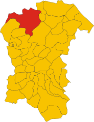
- Italian comune
 Hiking in Elice
Elice is a charming village located in the province of Pescara, in the Abruzzo region of Italy. It offers a variety of hiking opportunities, particularly for those who enjoy exploring lesser-known trails with scenic views of both the surrounding countryside and the Majella National Park nearby.
Hiking Highlights in Elice:
-
Scenic Views: The trails around Elice offer stunning panoramic views of the surrounding landscapes, including rolling hills, olive groves, and distant mountain ranges.
-
Historical and Cultural Sites: While hiking, you may encounter various historical landmarks, such as ancient stone churches and traditional Abruzzese architecture, adding a cultural element to your outdoor adventure.
-
Trails: There are several walking paths suitable for different skill levels, from leisurely strolls to more challenging hikes. The terrain varies, so it’s ideal for both novice and experienced hikers.
-
Flora and Fauna: The region is rich in biodiversity, making it a great spot for nature enthusiasts. Look out for the local wildlife and a variety of plant species typical to mountainous regions.
-
Accessibility: Elice is relatively close to other hiking areas in the Abruzzo region, allowing for day trips to other well-known hiking spots, such as the paths in the Gran Sasso and Majella National Parks.
-
Local Cuisine: After your hike, indulge in the local cuisine. Abruzzo is famous for its hearty dishes, and many local restaurants offer traditional meals that can replenish your energy after a long day on the trails.
Tips for Hiking in Elice:
- Gear Up: Make sure to wear appropriate hiking shoes and bring plenty of water, snacks, and a map or GPS device, as some trails may not be well-marked.
- Check Weather: Abruzzo's weather can be unpredictable, so it's essential to check forecasts before heading out.
- Stay Safe: As with any hiking adventure, inform someone of your plans and estimated return time.
Overall, hiking in Elice can be a rewarding experience for nature lovers, adventure seekers, and anyone looking to explore the beautiful landscapes of this part of Italy. Remember to respect nature and leave no trace to keep the area pristine for future hikers!
- Country:

- Postal Code: 65010
- Local Dialing Code: 085
- Licence Plate Code: PE
- Coordinates: 42° 31' 0" N, 13° 58' 0" E


- GPS tracks (wikiloc): [Link]
- AboveSeaLevel: 259 м m
- Area: 14.31 sq km
- Population: 1693
- Web site: http://www.comunedielice.gov.it/
- Wikipedia en: wiki(en)
- Wikipedia: wiki(it)
- Wikidata storage: Wikidata: Q51362
- Wikipedia Commons Category: [Link]
- Freebase ID: [/m/0fg8nn]
- GeoNames ID: Alt: [6540013]
- OSM relation ID: [42058]
- UN/LOCODE: [ITEL2]
- ISTAT ID: 068018
- Italian cadastre code: D394
Shares border with regions:


Città Sant'Angelo
- Italian comune
Hiking in Città Sant'Angelo
Città Sant'Angelo is a beautiful town located in the Abruzzo region of Italy, and it offers a variety of hiking opportunities for outdoor enthusiasts. Nestled in the hills of the Pescara province, it's known for its stunning landscapes, historic architecture, and charming medieval town center. Here are some key points about hiking in Città Sant'Angelo:...
- Country:
- Postal Code: 65013
- Local Dialing Code: 085
- Licence Plate Code: PE
- Coordinates: 42° 31' 0" N, 14° 3' 0" E
- GPS tracks (wikiloc): [Link]
- AboveSeaLevel: 322 м m
- Area: 62.02 sq km
- Population: 15034
- Web site: [Link]
Collecorvino
- Italian comune
Hiking in Collecorvino
Collecorvino is a charming town located in the Abruzzo region of Italy, known for its scenic landscapes and outdoor activities, including hiking. The area surrounding Collecorvino offers beautiful trails that vary in difficulty, making it suitable for both beginner and experienced hikers....
- Country:
- Postal Code: 65010
- Local Dialing Code: 085
- Licence Plate Code: PE
- Coordinates: 42° 28' 0" N, 14° 1' 0" E
- GPS tracks (wikiloc): [Link]
- AboveSeaLevel: 254 м m
- Area: 31.99 sq km
- Population: 6060
- Web site: [Link]

Penne, Abruzzo
- Italian comune
Hiking in Penne, Abruzzo
Hiking in Penne, a charming town in the Abruzzo region of Italy, offers you a rich blend of natural beauty, historical significance, and cultural experiences. Here are some highlights and tips for hiking in this picturesque area:...
- Country:
- Postal Code: 65017
- Local Dialing Code: 085
- Licence Plate Code: PE
- Coordinates: 42° 27' 0" N, 13° 55' 0" E
- GPS tracks (wikiloc): [Link]
- AboveSeaLevel: 438 м m
- Area: 91.2 sq km
- Population: 12113
- Web site: [Link]


Picciano
- Italian comune
Hiking in Picciano
Picciano, a charming village located in the Abruzzo region of Italy, offers a unique hiking experience amidst its stunning landscapes and rich historical context. Here are some key points to consider if you’re planning a hiking trip in Picciano:...
- Country:
- Postal Code: 65010
- Local Dialing Code: 085
- Licence Plate Code: PE
- Coordinates: 42° 28' 31" N, 13° 59' 24" E
- GPS tracks (wikiloc): [Link]
- AboveSeaLevel: 153 м m
- Area: 7.56 sq km
- Population: 1346
- Web site: [Link]
Castilenti
- Italian comune
Hiking in Castilenti
Castilenti is a charming town located in the Abruzzo region of Italy, nestled in the foothills of the Apennine Mountains. The area is known for its scenic beauty, rich history, and the variety of outdoor activities it offers, including hiking....
- Country:
- Postal Code: 64035
- Local Dialing Code: 0861
- Licence Plate Code: TE
- Coordinates: 42° 32' 0" N, 13° 55' 0" E
- GPS tracks (wikiloc): [Link]
- AboveSeaLevel: 272 м m
- Area: 23.79 sq km
- Population: 1419
- Web site: [Link]