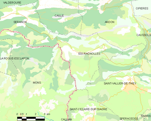
Escragnolles (Escragnolles)
- commune in Alpes-Maritimes, France
Escragnolles is a charming village located in the Alpes-Maritimes department in the Provence-Alpes-Côte d'Azur region of southern France. It's a part of the stunning French Riviera's mountainous landscape, offering numerous hiking opportunities for outdoor enthusiasts.
Hiking Trails and Opportunities
-
Scenic Views: The area around Escragnolles provides breathtaking views of the surrounding mountains and valleys, making it an excellent destination for photographers and nature lovers.
-
Moderate Trails: There are several marked trails suitable for various skill levels, from easy walks to more challenging hikes. Many trails are well-maintained, making them accessible for families and less-experienced hikers.
-
Flora and Fauna: The region is rich in biodiversity. Hikers can expect to see a variety of plant species, wildlife, and perhaps even beautiful wildflowers in the spring.
-
Nearby Natural Parks: Escragnolles is close to several natural parks, such as the Mercantour National Park, which offers more extensive and rugged hiking trails. This park features stunning landscapes, glacial lakes, and diverse wildlife.
Recommendations for Hiking in Escragnolles
-
Best Season: The ideal time to hike in this area is during the spring (April to June) and fall (September to October) when the weather is mild, and the summer crowds have diminished.
-
Gear: Wear appropriate hiking gear, including sturdy hiking boots, comfortable clothing, and bring plenty of water, snacks, and perhaps a map or a GPS device.
-
Safety: Always inform someone about your hiking plans and expected return time. It's advisable to hike with a partner or group, especially on less traveled trails.
-
Local Guides: For a more enriching experience, consider hiring a local guide who can share insights about the area's history, geology, and ecology.
Conclusion
Hiking in Escragnolles offers a wonderful opportunity to connect with nature while enjoying the serene beauty of the southern French Alps. Whether you're an experienced hiker or just looking for a peaceful walk in the mountains, Escragnolles has something to offer everyone.
- Country:

- Postal Code: 06460
- Coordinates: 43° 43' 51" N, 6° 47' 0" E


- GPS tracks (wikiloc): [Link]
- Area: 25.48 sq km
- Population: 614
- Wikipedia en: wiki(en)
- Wikipedia: wiki(fr)
- Wikidata storage: Wikidata: Q669328
- Wikipedia Commons Category: [Link]
- Freebase ID: [/m/03m4_mn]
- Freebase ID: [/m/03m4_mn]
- GeoNames ID: Alt: [3019753]
- GeoNames ID: Alt: [3019753]
- SIREN number: [210600581]
- SIREN number: [210600581]
- VIAF ID: Alt: [124777083]
- VIAF ID: Alt: [124777083]
- Library of Congress authority ID: Alt: [nr96013684]
- Library of Congress authority ID: Alt: [nr96013684]
- PACTOLS thesaurus ID: [pcrti9g8lZjZ4R]
- PACTOLS thesaurus ID: [pcrti9g8lZjZ4R]
- Digital Atlas of the Roman Empire ID: [42985]
- Digital Atlas of the Roman Empire ID: [42985]
- INSEE municipality code: 06058
- INSEE municipality code: 06058
Shares border with regions:


Caille
- commune in Alpes-Maritimes, France
Caille is a charming village located in the Alpes-Maritimes department of the Provence-Alpes-Côte d'Azur region in southeastern France. It is known for its beautiful natural settings, making it a great destination for hiking enthusiasts. Here are some highlights and tips for hiking in this area:...
- Country:

- Postal Code: 06750
- Coordinates: 43° 46' 45" N, 6° 43' 52" E


- GPS tracks (wikiloc): [Link]
- Area: 16.96 sq km
- Population: 446
- Web site: [Link]


Mons
- commune in Var, France
Mons, located in the Var department of the Provence-Alpes-Côte d'Azur region in southeastern France, offers a fantastic hiking experience amidst stunning natural beauty and rich cultural heritage. Here are some key points to consider if you're planning to hike in this area:...
- Country:

- Postal Code: 83440
- Coordinates: 43° 41' 29" N, 6° 42' 51" E


- GPS tracks (wikiloc): [Link]
- Area: 76.63 sq km
- Population: 853


Séranon
- commune in Alpes-Maritimes, France
Séranon is a charming village located in the Alpes-Maritimes region of France, renowned for its beautiful landscapes and picturesque hiking trails. Surrounded by the stunning scenery of the Provence-Alpes-Côte d'Azur, hiking in Séranon offers opportunities for both novice and experienced hikers alike....
- Country:

- Postal Code: 06750
- Coordinates: 43° 46' 27" N, 6° 42' 6" E


- GPS tracks (wikiloc): [Link]
- Area: 23.28 sq km
- Population: 487


Saint-Vallier-de-Thiey
- commune in Alpes-Maritimes, France
 Hiking in Saint-Vallier-de-Thiey
Saint-Vallier-de-Thiey is a charming village located in the Alpes-Maritimes department in southeastern France, offering a variety of hiking opportunities amidst beautiful landscapes. The region is characterized by its diverse terrain, which includes forested areas, rocky outcrops, and panoramic views of the surrounding mountains and valleys....
- Country:

- Postal Code: 06460
- Coordinates: 43° 41' 56" N, 6° 50' 52" E


- GPS tracks (wikiloc): [Link]
- Area: 50.68 sq km
- Population: 3526


Andon
- commune in Alpes-Maritimes, France
Andon, located in the Alpes-Maritimes region of France, is a charming village that offers a range of hiking opportunities amidst stunning natural landscapes. Nestled in the foothills of the Alpes, it serves as a gateway to the surrounding mountains and valleys. Here are some highlights and tips for hiking in and around Andon:...
- Country:

- Postal Code: 06750
- Coordinates: 43° 46' 23" N, 6° 47' 11" E


- GPS tracks (wikiloc): [Link]
- Area: 54.3 sq km
- Population: 562
- Web site: [Link]

Saint-Cézaire-sur-Siagne
- commune in Alpes-Maritimes, France
 Hiking in Saint-Cézaire-sur-Siagne
Saint-Cézaire-sur-Siagne is a picturesque village located in the Alpes-Maritimes department of France, near the Mediterranean coast. This area is renowned for its beautiful landscapes, lush vegetation, and proximity to the Siagne River, making it a wonderful spot for hiking enthusiasts....
- Country:

- Postal Code: 06530
- Coordinates: 43° 38' 56" N, 6° 47' 34" E


- GPS tracks (wikiloc): [Link]
- Area: 30.02 sq km
- Population: 3927
- Web site: [Link]
