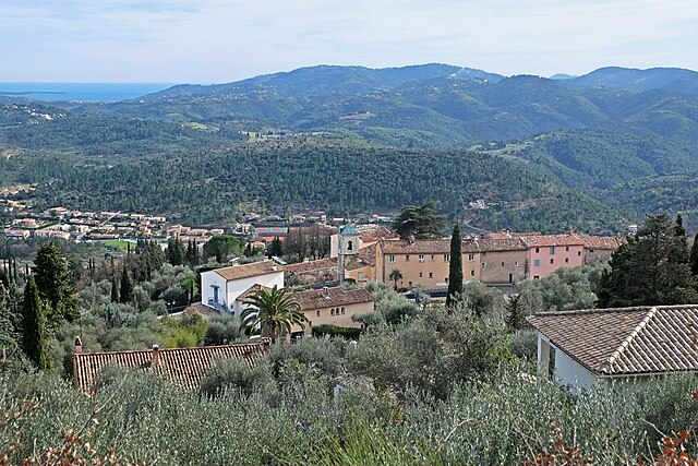
Saint-Cézaire-sur-Siagne (Saint-Cézaire-sur-Siagne)
- commune in Alpes-Maritimes, France
 Hiking in Saint-Cézaire-sur-Siagne
Saint-Cézaire-sur-Siagne is a picturesque village located in the Alpes-Maritimes department of France, near the Mediterranean coast. This area is renowned for its beautiful landscapes, lush vegetation, and proximity to the Siagne River, making it a wonderful spot for hiking enthusiasts.
Hiking Trails and Areas
-
Sentier des Murs: This marked trail offers a leisurely hike through scenic woodlands and features stunning views of the surrounding countryside. It's suitable for various skill levels and is especially popular among families.
-
Caves of Saint-Cézaire: While not a hiking trail per se, the nearby caves offer guided tours and can be incorporated into a hiking itinerary. The unique geology and subterranean formations can provide a fascinating backdrop to your hiking experience.
-
La Fontaine de la Siagne: Following the river, you can find numerous paths that wind through the natural landscape. This area is particularly lovely during the spring when wildflowers are in bloom.
-
Parc Naturel Régional des Préalpes d'Azur: Not far from Saint-Cézaire, this regional park offers a variety of hiking routes ranging from easy walks to more challenging hikes. The park is characterized by its diverse ecosystems, wildlife, and panoramic views.
Tips for Hiking in Saint-Cézaire-sur-Siagne
-
Weather Check: Before heading out, always check the weather forecast, as conditions can change quickly in the mountains.
-
Proper Gear: Wear sturdy hiking shoes and bring plenty of water, snacks, and sun protection, especially during the warmer months.
-
Maps: While many trails are well-marked, carrying a map or having a GPS device can help you navigate more remote paths.
-
Respect Nature: Stay on marked trails to protect the local flora and fauna, and remember to pack out any waste.
-
Local Information: Visit the local tourist office for up-to-date information on trail conditions, guided hikes, and any special events.
Conclusion
Hiking in Saint-Cézaire-sur-Siagne offers a unique opportunity to explore the natural beauty of the region while enjoying a blend of serene landscapes, historical sites, and local culture. Whether you're an experienced hiker or just looking for a leisurely walk in nature, this area has something to offer for everyone. Enjoy your hike!
- Country:

- Postal Code: 06530
- Coordinates: 43° 38' 56" N, 6° 47' 34" E


- GPS tracks (wikiloc): [Link]
- Area: 30.02 sq km
- Population: 3927
- Web site: http://www.saintcezairesursiagne.fr
- Wikipedia en: wiki(en)
- Wikipedia: wiki(fr)
- Wikidata storage: Wikidata: Q853458
- Wikipedia Commons Category: [Link]
- Freebase ID: [/m/03m4zzb]
- Freebase ID: [/m/03m4zzb]
- GeoNames ID: Alt: [2981217]
- GeoNames ID: Alt: [2981217]
- SIREN number: [210601183]
- SIREN number: [210601183]
- BnF ID: [12553089n]
- BnF ID: [12553089n]
- VIAF ID: Alt: [265867216]
- VIAF ID: Alt: [265867216]
- PACTOLS thesaurus ID: [pcrt2JudPj9FF8]
- PACTOLS thesaurus ID: [pcrt2JudPj9FF8]
- SUDOC authorities ID: [034817441]
- SUDOC authorities ID: [034817441]
- INSEE municipality code: 06118
- INSEE municipality code: 06118
Shares border with regions:


Mons
- commune in Var, France
Hiking in Mons
Mons, located in the Var department of the Provence-Alpes-Côte d'Azur region in southeastern France, offers a fantastic hiking experience amidst stunning natural beauty and rich cultural heritage. Here are some key points to consider if you're planning to hike in this area:...
- Country:
- Postal Code: 83440
- Coordinates: 43° 41' 29" N, 6° 42' 51" E
- GPS tracks (wikiloc): [Link]
- Area: 76.63 sq km
- Population: 853


Spéracèdes
- commune in Alpes-Maritimes, France
Hiking in Spéracèdes
Spéracèdes is a charming village located in the Alpes-Maritimes department in the Provence-Alpes-Côte d'Azur region of France. It offers a variety of hiking opportunities amidst stunning landscapes, rolling hills, and nearby natural parks. Here are some highlights and tips for hiking in and around Spéracèdes:...
- Country:
- Postal Code: 06530
- Coordinates: 43° 38' 55" N, 6° 51' 31" E
- GPS tracks (wikiloc): [Link]
- Area: 3.46 sq km
- Population: 1295

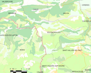
Escragnolles
- commune in Alpes-Maritimes, France
Hiking in Escragnolles
Escragnolles is a charming village located in the Alpes-Maritimes department in the Provence-Alpes-Côte d'Azur region of southern France. It's a part of the stunning French Riviera's mountainous landscape, offering numerous hiking opportunities for outdoor enthusiasts....
- Country:
- Postal Code: 06460
- Coordinates: 43° 43' 51" N, 6° 47' 0" E
- GPS tracks (wikiloc): [Link]
- Area: 25.48 sq km
- Population: 614


Callian
- commune in Var, France
Hiking in Callian
Callian is a picturesque village located in the Var department of the Provence-Alpes-Côte d'Azur region in southeastern France. Known for its medieval charm and stunning views of the surrounding countryside, Callian offers a range of hiking opportunities that cater to different skill levels. Here’s what you should know about hiking in and around Callian:...
- Country:
- Postal Code: 83440
- Coordinates: 43° 37' 20" N, 6° 45' 11" E
- GPS tracks (wikiloc): [Link]
- Area: 25.42 sq km
- Population: 3238
- Web site: [Link]


Montauroux
- commune in Var, France
Hiking in Montauroux
Montauroux, located in the Var department of the Provence-Alpes-Côte d'Azur region in southeastern France, offers a stunning backdrop for hikers with its picturesque landscapes, charming villages, and proximity to the beautiful French Riviera. Here are some highlights about hiking in Montauroux:...
- Country:
- Postal Code: 83440
- Coordinates: 43° 37' 6" N, 6° 45' 55" E
- GPS tracks (wikiloc): [Link]
- Area: 33.54 sq km
- Population: 6298


Saint-Vallier-de-Thiey
- commune in Alpes-Maritimes, France
Hiking in Saint-Vallier-de-Thiey
Saint-Vallier-de-Thiey is a charming village located in the Alpes-Maritimes department in southeastern France, offering a variety of hiking opportunities amidst beautiful landscapes. The region is characterized by its diverse terrain, which includes forested areas, rocky outcrops, and panoramic views of the surrounding mountains and valleys....
- Country:
- Postal Code: 06460
- Coordinates: 43° 41' 56" N, 6° 50' 52" E
- GPS tracks (wikiloc): [Link]
- Area: 50.68 sq km
- Population: 3526

Le Tignet
- commune in Alpes-Maritimes, France
Hiking in Le Tignet
Le Tignet is a charming village located in the Alpes-Maritimes region of France, not far from the French Riviera. It's known for its beautiful landscapes, picturesque views, and proximity to the Verdon Gorge and the hills of the Provence hinterlands. Here are some key aspects of hiking in this area:...
- Country:
- Postal Code: 06530
- Coordinates: 43° 37' 45" N, 6° 50' 37" E
- GPS tracks (wikiloc): [Link]
- Area: 11.26 sq km
- Population: 3311