Eymet (Eymet)

- commune in Dordogne, France
- Country:

- Postal Code: 24500
- Coordinates: 44° 40' 3" N, 0° 23' 54" E


- GPS tracks (wikiloc): [Link]
- Area: 31.25 sq km
- Population: 2662
- Web site: http://www.eymet-dordogne.fr
- Wikipedia en: wiki(en)
- Wikipedia: wiki(fr)
- Wikidata storage: Wikidata: Q864102
- Wikipedia Commons Category: [Link]
- Freebase ID: [/m/03mg60t]
- Freebase ID: [/m/03mg60t]
- GeoNames ID: Alt: [3019212]
- GeoNames ID: Alt: [3019212]
- SIREN number: [212401673]
- SIREN number: [212401673]
- BnF ID: [152518162]
- BnF ID: [152518162]
- VIAF ID: Alt: [138441090]
- VIAF ID: Alt: [138441090]
- Library of Congress authority ID: Alt: [n85149688]
- Library of Congress authority ID: Alt: [n85149688]
- MusicBrainz area ID: [d778e3f3-2d24-434b-8592-5f2579248c4c]
- MusicBrainz area ID: [d778e3f3-2d24-434b-8592-5f2579248c4c]
- WOEID: [590437]
- WOEID: [590437]
- INSEE municipality code: 24167
- INSEE municipality code: 24167
Shares border with regions:


Agnac
- commune in Lot-et-Garonne, France
- Country:
- Postal Code: 47800
- Coordinates: 44° 38' 33" N, 0° 23' 10" E
- GPS tracks (wikiloc): [Link]
- Area: 13.84 sq km
- Population: 441
- Web site: [Link]


Lauzun
- commune in Lot-et-Garonne, France
- Country:
- Postal Code: 47410
- Coordinates: 44° 37' 47" N, 0° 27' 38" E
- GPS tracks (wikiloc): [Link]
- AboveSeaLevel: 98 м m
- Area: 24.09 sq km
- Population: 730
- Web site: [Link]

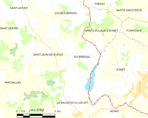
Soumensac
- commune in Lot-et-Garonne, France
- Country:
- Postal Code: 47120
- Coordinates: 44° 41' 23" N, 0° 19' 37" E
- GPS tracks (wikiloc): [Link]
- Area: 11.42 sq km
- Population: 234


La Sauvetat-du-Dropt
- commune in Lot-et-Garonne, France
- Country:
- Postal Code: 47800
- Coordinates: 44° 38' 50" N, 0° 20' 20" E
- GPS tracks (wikiloc): [Link]
- Area: 10.37 sq km
- Population: 539
- Web site: [Link]


Bourgougnague
- commune in Lot-et-Garonne, France
- Country:
- Postal Code: 47410
- Coordinates: 44° 37' 0" N, 0° 24' 59" E
- GPS tracks (wikiloc): [Link]
- Area: 11.73 sq km
- Population: 299

Fonroque
- commune in Dordogne, France
- Country:
- Postal Code: 24500
- Coordinates: 44° 42' 7" N, 0° 25' 4" E
- GPS tracks (wikiloc): [Link]
- Area: 9 sq km
- Population: 314