Eyragues (Eyragues)

- commune in Bouches-du-Rhône, France
- Country:

- Postal Code: 13630
- Coordinates: 43° 50' 28" N, 4° 50' 28" E


- GPS tracks (wikiloc): [Link]
- Area: 20.78 sq km
- Population: 4354
- Web site: http://www.eyragues.fr
- Wikipedia en: wiki(en)
- Wikipedia: wiki(fr)
- Wikidata storage: Wikidata: Q474002
- Wikipedia Commons Category: [Link]
- Freebase ID: [/m/02rp8yz]
- GeoNames ID: Alt: [6447125]
- SIREN number: [211300363]
- BnF ID: [15247318m]
- VIAF ID: Alt: [238750161]
- WOEID: [12661189]
- INSEE municipality code: 13036
Shares border with regions:

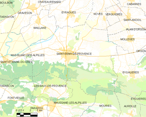
Saint-Rémy-de-Provence
- commune in Bouches-du-Rhône, France
- Country:
- Postal Code: 13210
- Coordinates: 43° 47' 22" N, 4° 49' 54" E
- GPS tracks (wikiloc): [Link]
- Area: 89.09 sq km
- Population: 9775
- Web site: [Link]


Graveson
- commune in Bouches-du-Rhône, France
- Country:
- Postal Code: 13690
- Coordinates: 43° 51' 4" N, 4° 46' 24" E
- GPS tracks (wikiloc): [Link]
- Area: 23.54 sq km
- Population: 4838
- Web site: [Link]


Châteaurenard
- commune in Bouches-du-Rhône, France
- Country:
- Postal Code: 13160
- Coordinates: 43° 52' 57" N, 4° 51' 18" E
- GPS tracks (wikiloc): [Link]
- Area: 34.95 sq km
- Population: 15624
- Web site: [Link]

Noves
- commune in Bouches-du-Rhône, France
- Country:
- Postal Code: 13550
- Coordinates: 43° 52' 37" N, 4° 54' 5" E
- GPS tracks (wikiloc): [Link]
- Area: 27.92 sq km
- Population: 5761
- Web site: [Link]


Maillane
- commune in Bouches-du-Rhône, France
- Country:
- Postal Code: 13910
- Coordinates: 43° 49' 58" N, 4° 46' 55" E
- GPS tracks (wikiloc): [Link]
- Area: 16.77 sq km
- Population: 2518
- Web site: [Link]