%20(cropped).jpg)
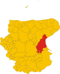
Foggia (Foggia)
.svg)
- Italian comune
 Hiking in Foggia
Foggia, located in the Apulia region of southeastern Italy, offers a diverse range of hiking opportunities that cater to various skill levels and preferences. The surrounding areas are known for their rich natural beauty, historical significance, and unique landscapes.
Hiking Trails and Natural Parks
-
Gargano National Park:
- Located north of Foggia, Gargano is one of Italy's most beautiful national parks. It encompasses diverse environments, including forests, cliffs, and beaches. Popular hiking trails include those around the Umbra Forest and the coastline, where you can enjoy stunning views of the Adriatic Sea.
-
Foresta Umbra:
- This area is part of Gargano National Park and features lush beech and oak forests. Several trails wind through the forest, ranging from easy walks to more challenging hikes. The forest is also home to various wildlife, making it a great spot for nature lovers.
-
Monte Sant’Angelo:
- This historical town offers trails that connect to surrounding natural landscapes, providing panoramic views of both the landscape and the sea. The area is rich in history, and you can combine hiking with visits to local sites like the Sanctuary of Monte Sant’Angelo.
-
The Tavoliere delle Puglie:
- This flat area offers unique landscapes and agricultural fields. While not mountainous, it provides opportunities for walking and exploring the local countryside, rich in flora and fauna.
Things to Consider
-
Weather: The ideal time for hiking in Foggia is during the spring (April to June) and autumn (September to November) when the weather is mild. Summer can be quite hot, making early morning or late afternoon hikes more pleasant.
-
Equipment: Depending on the trail, be sure to wear appropriate hiking footwear. Carry water, snacks, and a first-aid kit, and consider bringing a map or using a trail app.
-
Local Culture: While hiking, take the time to appreciate local culture and food. Many small towns in Foggia offer local culinary specialties, so you can refuel after your hike.
-
Guided Tours: If you are unfamiliar with the area, consider joining guided hiking tours, which can enhance your experience with local knowledge about the terrain and history.
Hiking in and around Foggia offers a great mix of natural beauty, cultural richness, and adventure. Whether you’re an experienced hiker or a beginner, there’s something for everyone in this beautiful part of Italy.
- Country:

- Postal Code: 71121–71122
- Local Dialing Code: 0881
- Licence Plate Code: FG
- Coordinates: 41° 28' 0" N, 15° 34' 0" E


- GPS tracks (wikiloc): [Link]
- AboveSeaLevel: 76 м m
- Area: 509.26 sq km
- Population: 151975
- Web site: http://www.comune.foggia.it/
- Wikipedia en: wiki(en)
- Wikipedia: wiki(it)
- Wikidata storage: Wikidata: Q13464
- Wikipedia Commons Gallery: [Link]
- Wikipedia Commons Category: [Link]
- Freebase ID: [/m/076919]
- GeoNames ID: Alt: [6541857]
- BnF ID: [11939635z]
- VIAF ID: Alt: [34145424498086830784]
- OSM relation ID: [41243]
- GND ID: Alt: [4086505-8]
- archINFORM location ID: [9278]
- Library of Congress authority ID: Alt: [n79021782]
- MusicBrainz area ID: [44e37bc2-a0f3-4d33-a69a-189bb6f71283]
- Quora topic ID: [Foggia-Italy]
- UN/LOCODE: [ITFOG]
- Encyclopædia Britannica Online ID: [place/Foggia]
- EMLO location ID: [50d3fc09-940e-4c5c-b97b-a14634d5ea90]
- Facebook Places ID: [106001806104714]
- DMOZ ID: Alt: [Regional/Europe/Italy/Regions/Puglia/Localities/Foggia/]
- Treccani ID: [foggia]
- ISTAT ID: 071024
- Italian cadastre code: D643
Shares border with regions:


San Severo
- Italian comune
Hiking in San Severo
San Severo, located in the Apulia region of Italy, is known for its rich history, picturesque landscapes, and agricultural fields. While it may not be as famous as other Italian hiking destinations, it offers some charming opportunities for outdoor enthusiasts. Here are some aspects to consider for hiking in this area:...
- Country:
- Postal Code: 71016
- Local Dialing Code: 0882
- Licence Plate Code: FG
- Coordinates: 41° 41' 42" N, 15° 22' 45" E
- GPS tracks (wikiloc): [Link]
- AboveSeaLevel: 90 м m
- Area: 333 sq km
- Population: 53015
- Web site: [Link]

Manfredonia
- Italian comune
Hiking in Manfredonia
Manfredonia, located on the Adriatic coast of Italy in the Apulia region, offers a unique blend of natural beauty, cultural heritage, and hiking opportunities. The area is characterized by its stunning coastline, historical sites, and proximity to the Gargano National Park, which is a haven for outdoor enthusiasts....
- Country:
- Postal Code: 71043
- Local Dialing Code: 0884
- Licence Plate Code: FG
- Coordinates: 41° 38' 0" N, 15° 55' 0" E
- GPS tracks (wikiloc): [Link]
- AboveSeaLevel: 5 м m
- Area: 354.54 sq km
- Population: 56906
- Web site: [Link]
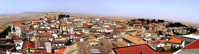

Ascoli Satriano
- Italian comune
Hiking in Ascoli Satriano
Ascoli Satriano, located in the Puglia region of Italy, offers a variety of hiking opportunities amidst stunning landscapes and rich cultural heritage. Here are some key points about hiking in the area:...
- Country:
- Postal Code: 71022
- Local Dialing Code: 0885
- Licence Plate Code: FG
- Coordinates: 41° 12' 56" N, 15° 33' 28" E
- GPS tracks (wikiloc): [Link]
- AboveSeaLevel: 376 м m
- Area: 336.68 sq km
- Population: 6167
- Web site: [Link]
Carapelle
- Italian comune
Hiking in Carapelle
Carapelle, a charming town in the Apulia region of Italy, offers a variety of hiking opportunities, particularly due to its proximity to the beautiful landscapes of the Gargano National Park and the coastal trails along the Adriatic Sea....
- Country:
- Postal Code: 71041
- Local Dialing Code: 0885
- Licence Plate Code: FG
- Coordinates: 41° 22' 0" N, 15° 42' 0" E
- GPS tracks (wikiloc): [Link]
- AboveSeaLevel: 62 м m
- Area: 25 sq km
- Population: 6692
- Web site: [Link]
Castelluccio dei Sauri
- Italian comune
Hiking in Castelluccio dei Sauri
Castelluccio dei Sauri, a charming village located in the Apennine Mountains of Italy, is an excellent destination for hiking enthusiasts. Nestled in the province of Foggia, in the region of Puglia, this area is characterized by its stunning landscapes, varied terrain, and rich biodiversity....
- Country:
- Postal Code: 71025
- Local Dialing Code: 0881
- Licence Plate Code: FG
- Coordinates: 41° 18' 0" N, 15° 29' 0" E
- GPS tracks (wikiloc): [Link]
- AboveSeaLevel: 284 м m
- Area: 51.47 sq km
- Population: 2102
- Web site: [Link]

Lucera
- Italian comune
Hiking in Lucera
Lucera, located in the Apulia region of southern Italy, offers a variety of hiking opportunities that allow you to experience the beautiful landscapes, historical sites, and unique flora and fauna of the area. Here are some key points to consider for hiking in and around Lucera:...
- Country:
- Postal Code: 71036
- Local Dialing Code: 0881
- Licence Plate Code: FG
- Coordinates: 41° 30' 0" N, 15° 20' 0" E
- GPS tracks (wikiloc): [Link]
- AboveSeaLevel: 50 м m
- Area: 339.79 sq km
- Population: 33085
- Web site: [Link]


Ordona
- Italian comune
Hiking in Ordona
Ordona is a small town in the province of Foggia, Italy, and while it may not be as widely recognized for hiking as some other destinations, there are still opportunities for outdoor enthusiasts in the surrounding areas....
- Country:
- Postal Code: 71040
- Local Dialing Code: 0885
- Licence Plate Code: FG
- Coordinates: 41° 19' 0" N, 15° 38' 0" E
- GPS tracks (wikiloc): [Link]
- AboveSeaLevel: 120 м m
- Area: 39.57 sq km
- Population: 2843
- Web site: [Link]


Rignano Garganico
- Italian comune
Hiking in Rignano Garganico
Rignano Garganico is a charming village located in the Apulia region of Italy, nestled in the Gargano National Park. This area is known for its stunning natural landscapes, diverse ecosystems, and rich cultural heritage, making it an excellent destination for hiking enthusiasts....
- Country:
- Postal Code: 71010
- Local Dialing Code: 0882
- Licence Plate Code: FG
- Coordinates: 41° 41' 0" N, 15° 35' 0" E
- GPS tracks (wikiloc): [Link]
- AboveSeaLevel: 590 м m
- Area: 89.4 sq km
- Population: 2017
- Web site: [Link]


San Giovanni Rotondo
- Italian comune
Hiking in San Giovanni Rotondo
San Giovanni Rotondo, located in the Apulia region of Italy, is not only famous for being the home of Padre Pio but also offers beautiful landscapes and hiking opportunities for outdoor enthusiasts. The area surrounding the town boasts picturesque scenery, with rolling hills, limestone cliffs, and a mix of Mediterranean vegetation....
- Country:
- Postal Code: 71013
- Local Dialing Code: 0882
- Licence Plate Code: FG
- Coordinates: 41° 42' 0" N, 15° 44' 0" E
- GPS tracks (wikiloc): [Link]
- AboveSeaLevel: 565 м m
- Area: 261.88 sq km
- Population: 27172
- Web site: [Link]


San Marco in Lamis
- Italian comune
Hiking in San Marco in Lamis
San Marco in Lamis, located in the Apulia region of Italy, offers a variety of hiking opportunities amidst beautiful natural landscapes and historical sites. Here are some key points about hiking in this area:...
- Country:
- Postal Code: 71014
- Local Dialing Code: 0882
- Licence Plate Code: FG
- Coordinates: 41° 42' 42" N, 15° 38' 6" E
- GPS tracks (wikiloc): [Link]
- AboveSeaLevel: 550 м m
- Area: 234.2 sq km
- Population: 13583
- Web site: [Link]


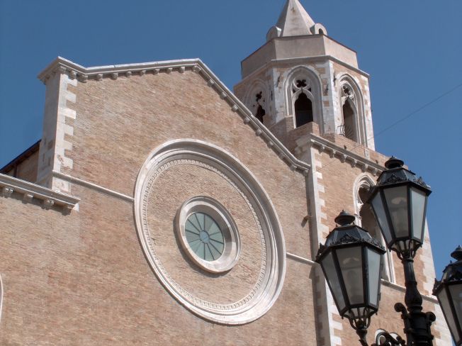
Troia, Apulia
- Italian comune
Hiking in Troia, Apulia
Troia is a charming town located in the Apulia region of southern Italy, known for its rich history and beautiful landscapes. Hiking in and around Troia offers a mix of cultural experiences and natural beauty, making it a great destination for outdoor enthusiasts. Here are some highlights for hiking in this area:...
- Country:
- Postal Code: 71029
- Local Dialing Code: 0881
- Licence Plate Code: FG
- Coordinates: 41° 22' 0" N, 15° 18' 0" E
- GPS tracks (wikiloc): [Link]
- AboveSeaLevel: 439 м m
- Area: 168.25 sq km
- Population: 7100
- Web site: [Link]