
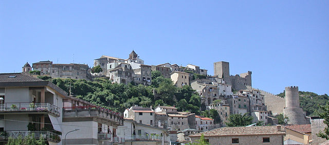
Fondi (Fondi)
.svg)
- Italian comune
 Hiking in Fondi
Fondi, located in the province of Latina in the Lazio region of Italy, is a beautiful area that offers a range of hiking opportunities. The region is characterized by its stunning landscapes, combining coastal views, rolling hills, and historical sites. Here are some highlights about hiking in Fondi:
Trails and Natural Parks
-
Monti Ausoni and Lago di Fondi: This natural park features a variety of trails that take you through lush forests and up to panoramic viewpoints. You can hike around the shores of Lake Fondi, which is not only scenic but also rich in biodiversity.
-
The Path of the Ancient Romans: This is a historical trail that links ancient sites in the area. It offers a great way to combine hiking with a bit of culture and history, as you explore ruins and remnants from Roman times.
-
Coastal Hiking: The nearby coastline, including the areas around Sperlonga and Gaeta, offers beautiful seaside trails. These paths can provide breathtaking views of the Tyrrhenian Sea and charming beaches to take breaks.
Tips for Hikers
-
Best Time to Hike: The spring (April to June) and fall (September to October) are ideal times for hiking in Fondi. The temperatures are mild, and the natural scenery is particularly beautiful during these seasons.
-
Preparation: Make sure to wear sturdy hiking boots, bring enough water, and pack snacks. A map or GPS device is also useful, as some trails may not be well-marked.
-
Guided Tours: If you're unfamiliar with the area, consider joining a guided hiking tour. Local guides can provide insights into the flora, fauna, and history of the region while ensuring safety on the trails.
-
Respect Nature: As with any outdoor activity, be sure to follow Leave No Trace principles, stick to marked trails, and respect any wildlife you may encounter.
By exploring the hiking trails in Fondi, you can enjoy not just the natural beauty of the Italian landscape, but also the rich cultural heritage of the region. Happy hiking!
- Country:

- Postal Code: 04022
- Local Dialing Code: 0771
- Licence Plate Code: LT
- Coordinates: 41° 21' 0" N, 13° 25' 0" E


- GPS tracks (wikiloc): [Link]
- AboveSeaLevel: 8 м m
- Area: 143.92 sq km
- Population: 39779
- Web site: http://www.comunedifondi.it/
- Wikipedia en: wiki(en)
- Wikipedia: wiki(it)
- Wikidata storage: Wikidata: Q128084
- Wikipedia Commons Gallery: [Link]
- Wikipedia Commons Category: [Link]
- Freebase ID: [/m/046h5n]
- GeoNames ID: Alt: [6541136]
- VIAF ID: Alt: [305114836]
- OSM relation ID: [41215]
- UN/LOCODE: [ITFND]
- Encyclopædia Britannica Online ID: [place/Fondi]
- Digital Atlas of the Roman Empire ID: [16713]
- ISTAT ID: 059007
- Italian cadastre code: D662
Shares border with regions:


Vallecorsa
- Italian comune
Hiking in Vallecorsa
Vallecorsa is a charming town located in the Lazio region of Italy, surrounded by the scenic landscapes of the Apennine mountains. The area is ideal for hiking enthusiasts looking to explore picturesque trails and enjoy the natural beauty of the Italian countryside....
- Country:
- Postal Code: 03020
- Local Dialing Code: 0775
- Licence Plate Code: FR
- Coordinates: 41° 27' 0" N, 13° 24' 0" E
- GPS tracks (wikiloc): [Link]
- AboveSeaLevel: 350 м m
- Area: 39.28 sq km
- Population: 2574
- Web site: [Link]


Campodimele
- Italian comune
Hiking in Campodimele
Campodimele, known as the "Village of Longevity," is a picturesque destination in the Italian region of Lazio, particularly in the province of Latina. Not only is it famous for its scenic beauty and rich history, but it also offers a variety of hiking trails that cater to different skill levels....
- Country:
- Postal Code: 04020
- Local Dialing Code: 0771
- Licence Plate Code: LT
- Coordinates: 41° 23' 0" N, 13° 32' 0" E
- GPS tracks (wikiloc): [Link]
- AboveSeaLevel: 647 м m
- Area: 38.38 sq km
- Population: 598
- Web site: [Link]

Itri
- Italian comune
Hiking in Itri
Itri, a charming town in the province of Latina in Italy, is surrounded by beautiful landscapes that make it a fantastic destination for hiking enthusiasts. Located near the Aurunci Mountains and close to the Tyrrhenian Sea, Itri offers a variety of trails that cater to different skill levels and preferences....
- Country:
- Postal Code: 04020
- Local Dialing Code: 0771
- Licence Plate Code: LT
- Coordinates: 41° 17' 0" N, 13° 32' 0" E
- GPS tracks (wikiloc): [Link]
- AboveSeaLevel: 170 м m
- Area: 101.1 sq km
- Population: 10761
- Web site: [Link]


Lenola, Lazio
- Italian comune
Hiking in Lenola, Lazio
Lenola, located in the province of Latina in the Lazio region of Italy, is an excellent destination for hiking enthusiasts. Nestled in the Aurunci Mountains, this charming town offers a blend of stunning natural beauty, historical sites, and diverse hiking trails....
- Country:
- Postal Code: 04025
- Local Dialing Code: 0771
- Licence Plate Code: LT
- Coordinates: 41° 24' 33" N, 13° 27' 45" E
- GPS tracks (wikiloc): [Link]
- AboveSeaLevel: 425 м m
- Area: 45.24 sq km
- Population: 4184
- Web site: [Link]


Monte San Biagio
- Italian comune
Hiking in Monte San Biagio
Monte San Biagio, located in the Lazio region of Italy, offers some beautiful hiking opportunities with stunning views and a rich natural environment. Here are a few key points about hiking in the area:...
- Country:
- Postal Code: 04020
- Local Dialing Code: 0771
- Licence Plate Code: LT
- Coordinates: 41° 21' 0" N, 13° 21' 0" E
- GPS tracks (wikiloc): [Link]
- AboveSeaLevel: 133 м m
- Area: 65.1 sq km
- Population: 6308
- Web site: [Link]
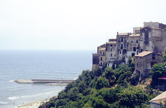

Sperlonga
- Italian comune
Hiking in Sperlonga
Sperlonga is a beautiful coastal town located in the Lazio region of Italy, known for its stunning beaches, crystal-clear waters, and rich historical sites. While it's primarily recognized for its seaside charm, there are also some excellent hiking opportunities in and around Sperlonga that allow you to explore its natural beauty and scenic landscapes....
- Country:
- Postal Code: 04029
- Local Dialing Code: 0771
- Licence Plate Code: LT
- Coordinates: 41° 16' 0" N, 13° 26' 0" E
- GPS tracks (wikiloc): [Link]
- AboveSeaLevel: 55 м m
- Area: 19.49 sq km
- Population: 3318
- Web site: [Link]

Terracina
- Italian comune
Hiking in Terracina
Terracina, located on the Italian coast of the Tyrrhenian Sea, is not only known for its beautiful beaches and ancient history but also offers excellent hiking opportunities. Here’s an insight into hiking in the area:...
- Country:
- Postal Code: 04019
- Local Dialing Code: 0773
- Licence Plate Code: LT
- Coordinates: 41° 17' 0" N, 13° 15' 0" E
- GPS tracks (wikiloc): [Link]
- AboveSeaLevel: 22 м m
- Area: 136.59 sq km
- Population: 46323
- Web site: [Link]