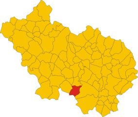
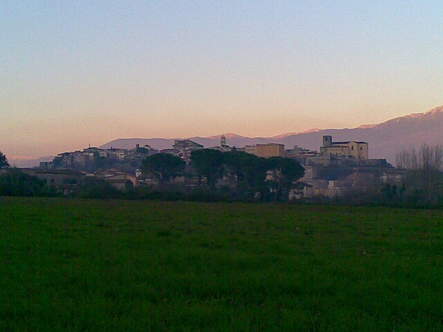
Campodimele (Campodimele)
.svg)
- Italian comune
 Hiking in Campodimele
Campodimele, known as the "Village of Longevity," is a picturesque destination in the Italian region of Lazio, particularly in the province of Latina. Not only is it famous for its scenic beauty and rich history, but it also offers a variety of hiking trails that cater to different skill levels.
Hiking Trails in Campodimele
-
Natural Paths: The area is surrounded by lush forests, olive groves, and panoramic views of the Aurunci Mountains and the Tyrrhenian Sea. Many trails weave through these landscapes, perfect for enjoying the local flora and fauna.
-
Difficulty Levels: There are trails suitable for both beginners and experienced hikers. Short, easy paths can be found around the village, while more challenging hikes can lead you up into the mountains for stunning views.
-
Cultural Experience: Hiking in and around Campodimele offers a glimpse into the local culture. You may encounter ancient ruins, charming churches, and traditional stone homes along the trails.
-
Points of Interest:
- Santa Croce Church: A historic church with stunning views.
- Nature Reserves: The nearby Mount Aurunci Regional Park offers marked trails and diverse ecosystems.
- Scenic Vistas: Many trails lead to lookout points where you can see the coastline and surrounding valleys.
-
Best Time to Hike: The ideal seasons for hiking in Campodimele are spring and autumn when the weather is mild, and the trails are often less crowded.
Safety Tips
- Gear: Wear appropriate footwear and bring enough water and snacks.
- Weather: Always check the weather forecast before heading out, as conditions can change quickly.
- Stay on Trails: To protect the environment, stick to marked paths and avoid disturbing wildlife.
Conclusion
Campodimele is a delightful hiking destination that combines natural beauty with cultural charm. Whether you are looking for a leisurely stroll or a more challenging hike, the area caters to all levels and provides a fantastic experience for outdoor enthusiasts.
- Country:

- Postal Code: 04020
- Local Dialing Code: 0771
- Licence Plate Code: LT
- Coordinates: 41° 23' 0" N, 13° 32' 0" E


- GPS tracks (wikiloc): [Link]
- AboveSeaLevel: 647 м m
- Area: 38.38 sq km
- Population: 598
- Web site: http://www.comune.campodimele.lt.it/
- Wikipedia en: wiki(en)
- Wikipedia: wiki(it)
- Wikidata storage: Wikidata: Q128060
- Wikipedia Commons Gallery: [Link]
- Wikipedia Commons Category: [Link]
- Freebase ID: [/m/0f8p9t]
- GeoNames ID: Alt: [6543603]
- VIAF ID: Alt: [242305727]
- OSM relation ID: [41258]
- ISTAT ID: 059003
- Italian cadastre code: B527
Shares border with regions:


Esperia
- Italian comune
Hiking in Esperia
Esperia is a picturesque town in the province of Frosinone in Italy, and it offers a variety of hiking opportunities that allow you to explore its beautiful natural landscapes, charming villages, and rich historical sites. Here are some highlights about hiking in and around Esperia:...
- Country:
- Postal Code: 03045
- Local Dialing Code: 0776
- Licence Plate Code: FR
- Coordinates: 41° 23' 0" N, 13° 41' 0" E
- GPS tracks (wikiloc): [Link]
- AboveSeaLevel: 370 м m
- Area: 108.57 sq km
- Population: 3802
- Web site: [Link]

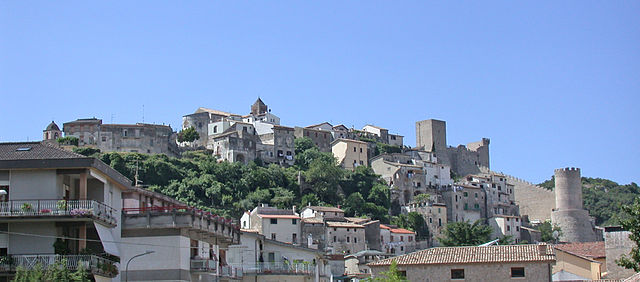
Pico, Lazio
- Italian comune
Hiking in Pico, Lazio
Pico is a charming village in the province of Frosinone, in the Lazio region of Italy. It's situated on the slopes of the Aurunci Mountains and offers various hiking opportunities for both experienced hikers and beginners. Here’s what you need to know about hiking in Pico:...
- Country:
- Postal Code: 03020
- Local Dialing Code: 0776
- Licence Plate Code: FR
- Coordinates: 41° 27' 5" N, 13° 33' 42" E
- GPS tracks (wikiloc): [Link]
- AboveSeaLevel: 190 м m
- Area: 32.93 sq km
- Population: 2825
- Web site: [Link]

Pontecorvo
- Italian comune
Hiking in Pontecorvo
Pontecorvo, located in the province of Frosinone in the Lazio region of Italy, is surrounded by picturesque landscapes and offers various hiking opportunities. The town is situated near the Garigliano River, and its surroundings include rolling hills, dense forests, and historical sites....
- Country:
- Postal Code: 03037
- Local Dialing Code: 0776
- Licence Plate Code: FR
- Coordinates: 41° 27' 45" N, 13° 40' 3" E
- GPS tracks (wikiloc): [Link]
- AboveSeaLevel: 97 м m
- Area: 88.23 sq km
- Population: 13125
- Web site: [Link]


Fondi
- Italian comune
Hiking in Fondi
Fondi, located in the province of Latina in the Lazio region of Italy, is a beautiful area that offers a range of hiking opportunities. The region is characterized by its stunning landscapes, combining coastal views, rolling hills, and historical sites. Here are some highlights about hiking in Fondi:...
- Country:
- Postal Code: 04022
- Local Dialing Code: 0771
- Licence Plate Code: LT
- Coordinates: 41° 21' 0" N, 13° 25' 0" E
- GPS tracks (wikiloc): [Link]
- AboveSeaLevel: 8 м m
- Area: 143.92 sq km
- Population: 39779
- Web site: [Link]

Itri
- Italian comune
Hiking in Itri
Itri, a charming town in the province of Latina in Italy, is surrounded by beautiful landscapes that make it a fantastic destination for hiking enthusiasts. Located near the Aurunci Mountains and close to the Tyrrhenian Sea, Itri offers a variety of trails that cater to different skill levels and preferences....
- Country:
- Postal Code: 04020
- Local Dialing Code: 0771
- Licence Plate Code: LT
- Coordinates: 41° 17' 0" N, 13° 32' 0" E
- GPS tracks (wikiloc): [Link]
- AboveSeaLevel: 170 м m
- Area: 101.1 sq km
- Population: 10761
- Web site: [Link]


Lenola, Lazio
- Italian comune
Hiking in Lenola, Lazio
Lenola, located in the province of Latina in the Lazio region of Italy, is an excellent destination for hiking enthusiasts. Nestled in the Aurunci Mountains, this charming town offers a blend of stunning natural beauty, historical sites, and diverse hiking trails....
- Country:
- Postal Code: 04025
- Local Dialing Code: 0771
- Licence Plate Code: LT
- Coordinates: 41° 24' 33" N, 13° 27' 45" E
- GPS tracks (wikiloc): [Link]
- AboveSeaLevel: 425 м m
- Area: 45.24 sq km
- Population: 4184
- Web site: [Link]