Itri (Itri)
.svg)
- Italian comune
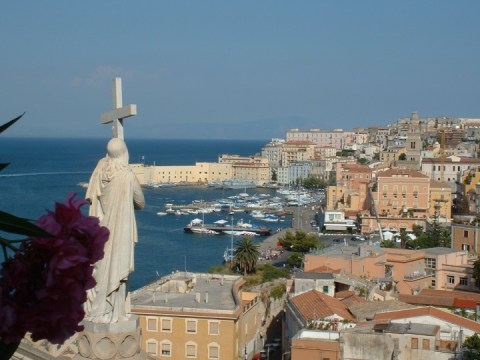
 Hiking in Itri
Itri, a charming town in the province of Latina in Italy, is surrounded by beautiful landscapes that make it a fantastic destination for hiking enthusiasts. Located near the Aurunci Mountains and close to the Tyrrhenian Sea, Itri offers a variety of trails that cater to different skill levels and preferences.
Popular Hiking Trails in and around Itri:
-
Monte Cucco: This trail takes you to the summit of Monte Cucco, where you can enjoy spectacular panoramic views of the surrounding mountains and the coastline. The hike can be challenging, with steep sections, but the scenery is well worth the effort.
-
The Path of the Gods (Sentiero degli Dei): Though not directly in Itri, this famous trail is accessible from nearby locations. It stretches along the cliffs of the Amalfi Coast and offers breathtaking views of the Mediterranean Sea. It’s a bit more challenging and requires good fitness levels, but it's immensely rewarding.
-
La Valle dei Mulini: This easier trail leads through a picturesque valley adorned with ancient mills and lush greenery. It’s perfect for a more leisurely hike, allowing you to immerse yourself in the natural beauty and tranquility of the area.
-
Itri to Sperlonga Coastal Trail: This scenic route connects Itri to the beautiful seaside town of Sperlonga. It's a relatively easy hike along the coast and features stunning sea views, rocky cliffs, and opportunities to enjoy the beach at the end of the trek.
Tips for Hiking in Itri:
- Weather: Check the weather conditions before heading out, as the region can experience sudden changes in weather, especially in the mountains.
- Proper Gear: Wear sturdy hiking boots and bring enough water, especially during the warmer months. A hat and sunscreen are also advisable.
- Wildlife and Nature: Be respectful of local flora and fauna. Observe wildlife from a distance and leave no trace of your visit.
- Local Guides: If you're unfamiliar with the area, consider hiring a local guide who can provide insight into the trails and ensure your safety.
- Trail Markings: Many trails are marked, but always have a map or GPS device handy, as some paths can be misleading.
Hiking in Itri allows you to enjoy a mix of history, culture, and stunning natural beauty, making it a memorable experience for outdoor lovers.
- Country:

- Postal Code: 04020
- Local Dialing Code: 0771
- Licence Plate Code: LT
- Coordinates: 41° 17' 0" N, 13° 32' 0" E


- GPS tracks (wikiloc): [Link]
- AboveSeaLevel: 170 м m
- Area: 101.1 sq km
- Population: 10761
- Web site: http://www.itri.it/
- Wikipedia en: wiki(en)
- Wikipedia: wiki(it)
- Wikidata storage: Wikidata: Q128092
- Wikipedia Commons Gallery: [Link]
- Wikipedia Commons Category: [Link]
- Freebase ID: [/m/044s8t]
- GeoNames ID: Alt: [6536970]
- VIAF ID: Alt: [147761449]
- OSM relation ID: [41175]
- WOEID: [716736]
- UN/LOCODE: [ITITR]
- ISTAT ID: 059010
- Italian cadastre code: E375
Shares border with regions:


Esperia
- Italian comune
Hiking in Esperia
Esperia is a picturesque town in the province of Frosinone in Italy, and it offers a variety of hiking opportunities that allow you to explore its beautiful natural landscapes, charming villages, and rich historical sites. Here are some highlights about hiking in and around Esperia:...
- Country:
- Postal Code: 03045
- Local Dialing Code: 0776
- Licence Plate Code: FR
- Coordinates: 41° 23' 0" N, 13° 41' 0" E
- GPS tracks (wikiloc): [Link]
- AboveSeaLevel: 370 м m
- Area: 108.57 sq km
- Population: 3802
- Web site: [Link]


Campodimele
- Italian comune
Hiking in Campodimele
Campodimele, known as the "Village of Longevity," is a picturesque destination in the Italian region of Lazio, particularly in the province of Latina. Not only is it famous for its scenic beauty and rich history, but it also offers a variety of hiking trails that cater to different skill levels....
- Country:
- Postal Code: 04020
- Local Dialing Code: 0771
- Licence Plate Code: LT
- Coordinates: 41° 23' 0" N, 13° 32' 0" E
- GPS tracks (wikiloc): [Link]
- AboveSeaLevel: 647 м m
- Area: 38.38 sq km
- Population: 598
- Web site: [Link]


Fondi
- Italian comune
Hiking in Fondi
Fondi, located in the province of Latina in the Lazio region of Italy, is a beautiful area that offers a range of hiking opportunities. The region is characterized by its stunning landscapes, combining coastal views, rolling hills, and historical sites. Here are some highlights about hiking in Fondi:...
- Country:
- Postal Code: 04022
- Local Dialing Code: 0771
- Licence Plate Code: LT
- Coordinates: 41° 21' 0" N, 13° 25' 0" E
- GPS tracks (wikiloc): [Link]
- AboveSeaLevel: 8 м m
- Area: 143.92 sq km
- Population: 39779
- Web site: [Link]


Formia
- Italian comune
Hiking in Formia
Formia, located on the Tyrrhenian coast of Italy in the Lazio region, is a beautiful destination for hiking enthusiasts. The area is known for its stunning coastal scenery, historical sites, and a variety of trails that cater to different skill levels. Here are some key points about hiking in Formia:...
- Country:
- Postal Code: 04023
- Local Dialing Code: 0771
- Licence Plate Code: LT
- Coordinates: 41° 15' 23" N, 13° 36' 25" E
- GPS tracks (wikiloc): [Link]
- AboveSeaLevel: 19 м m
- Area: 74.17 sq km
- Population: 38032
- Web site: [Link]

Gaeta
- Italian comune
Hiking in Gaeta
Gaeta, located along the Tyrrhenian Sea in Italy's Lazio region, is a beautiful coastal town that offers stunning views, rich history, and excellent hiking opportunities. Here are some highlights regarding hiking in the Gaeta area:...
- Country:
- Postal Code: 04024
- Local Dialing Code: 0771
- Licence Plate Code: LT
- Coordinates: 41° 13' 0" N, 13° 34' 0" E
- GPS tracks (wikiloc): [Link]
- AboveSeaLevel: 2 м m
- Area: 29.2 sq km
- Population: 20545
- Web site: [Link]
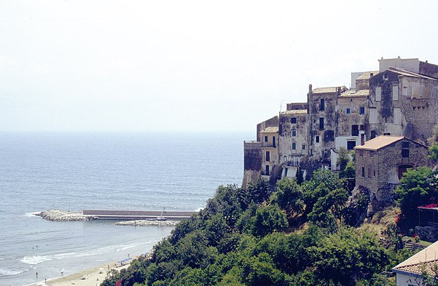

Sperlonga
- Italian comune
Hiking in Sperlonga
Sperlonga is a beautiful coastal town located in the Lazio region of Italy, known for its stunning beaches, crystal-clear waters, and rich historical sites. While it's primarily recognized for its seaside charm, there are also some excellent hiking opportunities in and around Sperlonga that allow you to explore its natural beauty and scenic landscapes....
- Country:
- Postal Code: 04029
- Local Dialing Code: 0771
- Licence Plate Code: LT
- Coordinates: 41° 16' 0" N, 13° 26' 0" E
- GPS tracks (wikiloc): [Link]
- AboveSeaLevel: 55 м m
- Area: 19.49 sq km
- Population: 3318
- Web site: [Link]