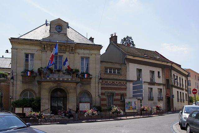
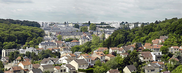
Fontenay-aux-Roses (Fontenay-aux-Roses)

- commune in Hauts-de-Seine, France
- Country:

- Postal Code: 92260
- Coordinates: 48° 47' 21" N, 2° 17' 8" E


- GPS tracks (wikiloc): [Link]
- AboveSeaLevel: 110 м m
- Area: 2.51 sq km
- Population: 23963
- Web site: http://www.fontenay-aux-roses.fr
- Wikipedia en: wiki(en)
- Wikipedia: wiki(fr)
- Wikidata storage: Wikidata: Q269166
- Wikipedia Commons Category: [Link]
- Wikipedia Commons Maps Category: [Link]
- Freebase ID: [/m/04jhww]
- Freebase ID: [/m/04jhww]
- Freebase ID: [/m/04jhww]
- GeoNames ID: Alt: [6451967]
- GeoNames ID: Alt: [6451967]
- GeoNames ID: Alt: [6451967]
- SIREN number: [219200326]
- SIREN number: [219200326]
- SIREN number: [219200326]
- BnF ID: [15280258q]
- BnF ID: [15280258q]
- BnF ID: [15280258q]
- VIAF ID: Alt: [242213606]
- VIAF ID: Alt: [242213606]
- VIAF ID: Alt: [242213606]
- GND ID: Alt: [4279026-8]
- GND ID: Alt: [4279026-8]
- GND ID: Alt: [4279026-8]
- archINFORM location ID: [45770]
- archINFORM location ID: [45770]
- archINFORM location ID: [45770]
- Library of Congress authority ID: Alt: [n83033862]
- Library of Congress authority ID: Alt: [n83033862]
- Library of Congress authority ID: Alt: [n83033862]
- MusicBrainz area ID: [68e1ab64-c7ee-40dc-903f-f53a4362b578]
- MusicBrainz area ID: [68e1ab64-c7ee-40dc-903f-f53a4362b578]
- MusicBrainz area ID: [68e1ab64-c7ee-40dc-903f-f53a4362b578]
- Quora topic ID: [Fontenay-aux-Roses]
- Quora topic ID: [Fontenay-aux-Roses]
- Quora topic ID: [Fontenay-aux-Roses]
- Gran Enciclopèdia Catalana ID: [0027548]
- Gran Enciclopèdia Catalana ID: [0027548]
- Gran Enciclopèdia Catalana ID: [0027548]
- INSEE municipality code: 92032
- INSEE municipality code: 92032
- INSEE municipality code: 92032
- US National Archives Identifier: 10037839
- US National Archives Identifier: 10037839
- US National Archives Identifier: 10037839
Shares border with regions:

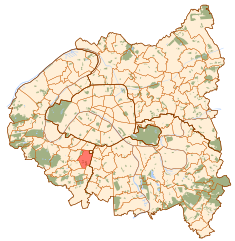
Bagneux
- commune in Hauts-de-Seine, France
- Country:
- Postal Code: 92220
- Coordinates: 48° 47' 52" N, 2° 18' 45" E
- GPS tracks (wikiloc): [Link]
- AboveSeaLevel: 90 м m
- Area: 4.19 sq km
- Population: 39487
- Web site: [Link]


Clamart
- commune in Hauts-de-Seine, France
- Country:
- Postal Code: 92140
- Coordinates: 48° 48' 3" N, 2° 15' 43" E
- GPS tracks (wikiloc): [Link]
- AboveSeaLevel: 120 м m
- Area: 8.77 sq km
- Population: 52645
- Web site: [Link]

Châtillon
- commune in Hauts-de-Seine, France
- Country:
- Postal Code: 92320
- Coordinates: 48° 48' 4" N, 2° 17' 19" E
- GPS tracks (wikiloc): [Link]
- AboveSeaLevel: 121 м m
- Area: 2.92 sq km
- Population: 37159
- Web site: [Link]

Le Plessis-Robinson
- commune in Hauts-de-Seine, France
- Country:
- Postal Code: 92350
- Coordinates: 48° 47' 0" N, 2° 15' 49" E
- GPS tracks (wikiloc): [Link]
- Area: 3.43 sq km
- Population: 28974
- Web site: [Link]


Sceaux
- commune in Hauts-de-Seine, France
- Country:
- Postal Code: 92330
- Coordinates: 48° 46' 43" N, 2° 17' 26" E
- GPS tracks (wikiloc): [Link]
- Area: 3.6 sq km
- Population: 19355
- Web site: [Link]