%20banner.jpg)
Fougerolles (Fougerolles)

- commune in Haute-Saône, France
- Country:

- Postal Code: 70220
- Coordinates: 47° 53' 7" N, 6° 24' 10" E


- GPS tracks (wikiloc): [Link]
- Area: 51.12 sq km
- Population: 3670
- Web site: http://fougerolles.fr/
- Wikipedia en: wiki(en)
- Wikipedia: wiki(fr)
- Wikidata storage: Wikidata: Q922794
- Wikipedia Commons Category: [Link]
- Freebase ID: [/m/03nvtp2]
- GeoNames ID: Alt: [6441947]
- SIREN number: [217002450]
- BnF ID: [15272638g]
- PACTOLS thesaurus ID: [pcrtFVo2nqL6Mz]
- INSEE municipality code: 70245
Shares border with regions:


Le Val-d'Ajol
- commune in Vosges, France
- Country:
- Postal Code: 88340
- Coordinates: 47° 55' 30" N, 6° 29' 0" E
- GPS tracks (wikiloc): [Link]
- Area: 73.33 sq km
- Population: 3896
- Web site: [Link]


Aillevillers-et-Lyaumont
- commune in Haute-Saône, France
- Country:
- Postal Code: 70320
- Coordinates: 47° 55' 13" N, 6° 20' 9" E
- GPS tracks (wikiloc): [Link]
- Area: 36.3 sq km
- Population: 1584
- Web site: [Link]


Plombières-les-Bains
- commune in Vosges, France
- Country:
- Postal Code: 88370
- Coordinates: 47° 57' 59" N, 6° 27' 47" E
- GPS tracks (wikiloc): [Link]
- Area: 27.2 sq km
- Population: 1699
- Web site: [Link]

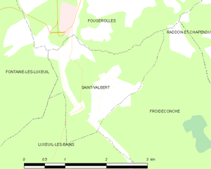
Saint-Valbert
- commune in Haute-Saône, France
- Country:
- Postal Code: 70300
- Coordinates: 47° 51' 9" N, 6° 23' 45" E
- GPS tracks (wikiloc): [Link]
- Area: 3.9 sq km
- Population: 245
- Web site: [Link]

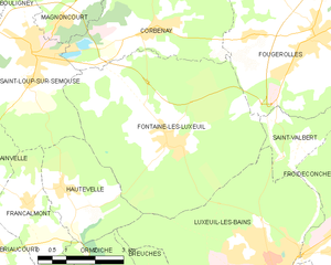
Fontaine-lès-Luxeuil
- commune in Haute-Saône, France
- Country:
- Postal Code: 70800
- Coordinates: 47° 51' 20" N, 6° 20' 5" E
- GPS tracks (wikiloc): [Link]
- Area: 27.73 sq km
- Population: 1379

Corbenay
- commune in Haute-Saône, France
- Country:
- Postal Code: 70320
- Coordinates: 47° 53' 27" N, 6° 19' 31" E
- GPS tracks (wikiloc): [Link]
- Area: 15.73 sq km
- Population: 1296
- Web site: [Link]

Saint-Bresson
- commune in Haute-Saône, France
- Country:
- Postal Code: 70280
- Coordinates: 47° 52' 13" N, 6° 30' 23" E
- GPS tracks (wikiloc): [Link]
- Area: 26.6 sq km
- Population: 450


La Vaivre
- commune in Haute-Saône, France
- Country:
- Postal Code: 70320
- Coordinates: 47° 54' 54" N, 6° 22' 2" E
- GPS tracks (wikiloc): [Link]
- AboveSeaLevel: 359 м m
- Area: 3.04 sq km
- Population: 210


Froideconche
- commune in Haute-Saône, France
- Country:
- Postal Code: 70300
- Coordinates: 47° 49' 14" N, 6° 24' 58" E
- GPS tracks (wikiloc): [Link]
- Area: 16.04 sq km
- Population: 1987
- Web site: [Link]


Raddon-et-Chapendu
- commune in Haute-Saône, France
- Country:
- Postal Code: 70280
- Coordinates: 47° 50' 30" N, 6° 28' 16" E
- GPS tracks (wikiloc): [Link]
- Area: 12.5 sq km
- Population: 896