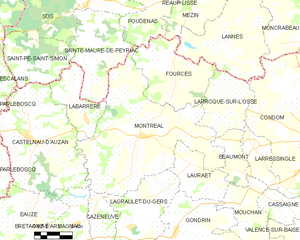
Fourcès (Fourcès)

- commune in Gers, France
- Country:

- Postal Code: 32250
- Coordinates: 43° 59' 35" N, 0° 13' 49" E


- GPS tracks (wikiloc): [Link]
- Area: 23.72 sq km
- Population: 269
- Web site: http://www.fources.fr
- Wikipedia en: wiki(en)
- Wikipedia: wiki(fr)
- Wikidata storage: Wikidata: Q632063
- Wikipedia Commons Category: [Link]
- Freebase ID: [/m/03gzmk5]
- GeoNames ID: Alt: [6431913]
- SIREN number: [213201338]
- BnF ID: [152557200]
- PACTOLS thesaurus ID: [pcrtE9Yq7OewGR]
- INSEE municipality code: 32133
Shares border with regions:


Poudenas
- commune in Lot-et-Garonne, France
- Country:
- Postal Code: 47170
- Coordinates: 44° 2' 47" N, 0° 12' 32" E
- GPS tracks (wikiloc): [Link]
- Area: 17.24 sq km
- Population: 253


Mézin
- commune in Lot-et-Garonne, France
- Country:
- Postal Code: 47170
- Coordinates: 44° 3' 24" N, 0° 15' 30" E
- GPS tracks (wikiloc): [Link]
- Area: 31.58 sq km
- Population: 1589
- Web site: [Link]


Lannes
- commune in Lot-et-Garonne, France
- Country:
- Postal Code: 47170
- Coordinates: 44° 2' 8" N, 0° 17' 36" E
- GPS tracks (wikiloc): [Link]
- Area: 32.4 sq km
- Population: 378

Montréal
- commune in Gers, France
- Country:
- Postal Code: 32250
- Coordinates: 43° 57' 0" N, 0° 12' 8" E
- GPS tracks (wikiloc): [Link]
- Area: 63.05 sq km
- Population: 1173
- Web site: [Link]


Larroque-sur-l'Osse
- commune in Gers, France
- Country:
- Postal Code: 32100
- Coordinates: 43° 58' 16" N, 0° 16' 28" E
- GPS tracks (wikiloc): [Link]
- AboveSeaLevel: 132 м m
- Area: 15.07 sq km
- Population: 242