Fournès (Fournès)

- commune in Gard, France
- Country:

- Postal Code: 30210
- Coordinates: 43° 55' 44" N, 4° 36' 5" E


- GPS tracks (wikiloc): [Link]
- Area: 17.66 sq km
- Population: 1068
- Wikipedia en: wiki(en)
- Wikipedia: wiki(fr)
- Wikidata storage: Wikidata: Q239856
- Wikipedia Commons Category: [Link]
- Freebase ID: [/m/03c0tlj]
- GeoNames ID: Alt: [6453948]
- SIREN number: [213001167]
- BnF ID: [15254756r]
- INSEE municipality code: 30116
Shares border with regions:


Remoulins
- commune in Gard, France
- Country:
- Postal Code: 30210
- Coordinates: 43° 56' 22" N, 4° 33' 50" E
- GPS tracks (wikiloc): [Link]
- AboveSeaLevel: 6 м m
- Area: 8.24 sq km
- Population: 2325
- Web site: [Link]


Estézargues
- commune in Gard, France
- Country:
- Postal Code: 30390
- Coordinates: 43° 56' 25" N, 4° 38' 13" E
- GPS tracks (wikiloc): [Link]
- Area: 11.59 sq km
- Population: 534


Montfrin
- commune in Gard, France
- Country:
- Postal Code: 30490
- Coordinates: 43° 52' 33" N, 4° 35' 36" E
- GPS tracks (wikiloc): [Link]
- Area: 15.29 sq km
- Population: 3211
- Web site: [Link]


Saint-Hilaire-d'Ozilhan
- commune in Gard, France
- Country:
- Postal Code: 30210
- Coordinates: 43° 58' 13" N, 4° 35' 31" E
- GPS tracks (wikiloc): [Link]
- Area: 16.66 sq km
- Population: 1044

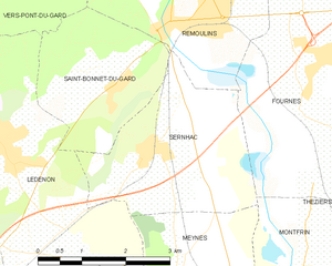
Sernhac
- commune in Gard, France
- Country:
- Postal Code: 30210
- Coordinates: 43° 54' 41" N, 4° 33' 7" E
- GPS tracks (wikiloc): [Link]
- Area: 8.93 sq km
- Population: 1718
- Web site: [Link]


Théziers
- commune in Gard, France
- Country:
- Postal Code: 30390
- Coordinates: 43° 53' 57" N, 4° 37' 15" E
- GPS tracks (wikiloc): [Link]
- Area: 11.34 sq km
- Population: 1080