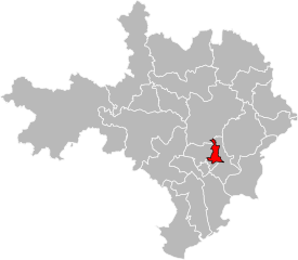
arrondissement of Nîmes (arrondissement de Nîmes)

- arrondissement of France
- Country:

- Capital: Nîmes
- Coordinates: 43° 55' 0" N, 4° 25' 0" E


- GPS tracks (wikiloc): [Link]
- Area: 3133 sq km
- Population: 551397
- Wikipedia en: wiki(en)
- Wikipedia: wiki(fr)
- Wikidata storage: Wikidata: Q702009
- Freebase ID: [/m/095k5g]
- GeoNames ID: Alt: [2990362]
- INSEE arrondissement code: [302]
- GNS Unique Feature ID: -1455069
Includes regions:


canton of Bagnols-sur-Cèze
- canton of France
- Country:
- Capital: Bagnols-sur-Cèze
- Coordinates: 44° 10' 0" N, 4° 37' 0" E
- GPS tracks (wikiloc): [Link]
- Population: 28781


canton of Aigues-Mortes
- canton of France
- Country:
- Capital: Aigues-Mortes
- Coordinates: 43° 34' 3" N, 4° 11' 36" E
- GPS tracks (wikiloc): [Link]
- Population: 34362

canton of Nîmes-4
- canton of France
- Country:
- Capital: Nîmes
- Coordinates: 43° 50' 20" N, 4° 21' 43" E
- GPS tracks (wikiloc): [Link]
- Population: 37936


canton of Villeneuve-lès-Avignon
- canton of France
- Country:
- Capital: Villeneuve-lès-Avignon
- Coordinates: 43° 58' 2" N, 4° 47' 48" E
- GPS tracks (wikiloc): [Link]
- Population: 33630


canton of Nîmes-1
- canton of France
- Country:
- Capital: Nîmes
- Coordinates: 43° 50' 20" N, 4° 21' 43" E
- GPS tracks (wikiloc): [Link]
- Population: 37265

canton of Nîmes-3
- canton of France
- Country:
- Capital: Nîmes
- Coordinates: 43° 50' 20" N, 4° 21' 43" E
- GPS tracks (wikiloc): [Link]
- Population: 36895


canton of Uzès
- canton of France
- Country:
- Capital: Uzès
- Coordinates: 44° 1' 0" N, 4° 25' 0" E
- GPS tracks (wikiloc): [Link]
- Population: 31910


canton of La Vistrenque
- canton of France
- Country:
- Capital: Bouillargues
- Coordinates: 43° 48' 0" N, 4° 26' 0" E
- GPS tracks (wikiloc): [Link]


canton of Roquemaure
- canton of France
- Country:
- Capital: Roquemaure
- Coordinates: 44° 3' 0" N, 4° 47' 0" E
- GPS tracks (wikiloc): [Link]
- Population: 26395


canton of Saint-Chaptes
- canton of France
- Country:
- Capital: Saint-Chaptes
- Coordinates: 43° 58' 0" N, 4° 17' 0" E
- GPS tracks (wikiloc): [Link]

canton of Saint-Mamert-du-Gard
- canton of France
- Country:
- Capital: Saint-Mamert-du-Gard
- Coordinates: 43° 53' 0" N, 4° 12' 0" E
- GPS tracks (wikiloc): [Link]


canton of Vauvert
- canton of France
- Country:
- Capital: Vauvert
- Coordinates: 43° 42' 0" N, 4° 17' 0" E
- GPS tracks (wikiloc): [Link]
- Population: 39643


canton of Beaucaire
- canton of France
- Country:
- Capital: Beaucaire
- Coordinates: 43° 48' 0" N, 4° 38' 0" E
- GPS tracks (wikiloc): [Link]
- Population: 36795
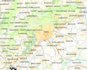
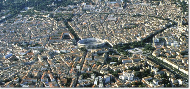
Nîmes
- commune in Gard, France
- Country:
- Postal Code: 30900; 30000
- Local Dialing Code: 466
- Coordinates: 43° 50' 13" N, 4° 21' 36" E
- GPS tracks (wikiloc): [Link]
- AboveSeaLevel: 215 м m
- Area: 161.85 sq km
- Population: 150672
- Web site: [Link]


canton of Saint-Gilles
- canton of France
- Country:
- Capital: Saint-Gilles
- Coordinates: 43° 41' 0" N, 4° 26' 0" E
- GPS tracks (wikiloc): [Link]
- Population: 35715


canton of Pont-Saint-Esprit
- canton of France
- Country:
- Capital: Pont-Saint-Esprit
- Coordinates: 44° 15' 0" N, 4° 39' 0" E
- GPS tracks (wikiloc): [Link]
- Population: 25681


canton of Marguerittes
- canton of France
- Country:
- Capital: Marguerittes
- Coordinates: 43° 51' 0" N, 4° 27' 0" E
- GPS tracks (wikiloc): [Link]
- Population: 37131