Francillon-sur-Roubion (Francillon-sur-Roubion)

- commune in Drôme, France
 Hiking in Francillon-sur-Roubion
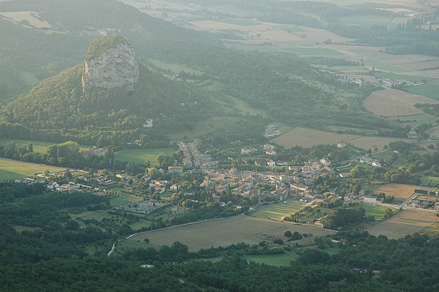
Francillon-sur-Roubion is a charming village located in the Drôme department of the Auvergne-Rhône-Alpes region in France. It's a great area for those interested in hiking, with its picturesque landscapes and varied terrain.
Hiking Opportunities:
-
Scenic Trails: The region offers a range of hiking trails that take you through beautiful countryside, vineyards, and olive groves. You can enjoy stunning views of the surrounding mountains and the Roubion River.
-
Nearby Natural Parks: It is close to the Vercors Regional Natural Park and the Baronnies Provençales Regional Natural Park, both of which provide access to numerous hiking routes that cater to all levels, from easy walks to more challenging hikes.
-
Local Flora and Fauna: As you hike, you'll have the opportunity to observe diverse flora and fauna. The area is known for its rich biodiversity, making it a great spot for nature lovers.
-
Historical and Cultural Sites: Some hiking routes may lead you to historical villages, ancient ruins, and local cultural sites, giving you a chance to explore the history and heritage of the region.
-
Difficulty Levels: Trails vary in difficulty, so whether you're a beginner or an experienced hiker, you'll find suitable paths. Always check trail markings and local maps for guidance.
Tips for Hiking in Francillon-sur-Roubion:
- Check the Weather: The weather can change rapidly, so it's important to check the forecast before heading out.
- Stay Hydrated: Bring enough water and snacks, especially if you're planning a longer hike.
- Hiking Gear: Wear appropriate footwear and clothing. Sturdy hiking shoes are recommended for varying terrains.
- Respect Nature: Follow the Leave No Trace principles. Stay on marked trails and clean up after yourself.
- Local Guides: Consider hiring a local guide for more in-depth knowledge about the area’s ecology and history, especially if you’re unfamiliar with the trails.
Enjoy your hiking adventure in Francillon-sur-Roubion! It's a wonderful way to experience the natural beauty and charm of this part of France.
- Country:

- Postal Code: 26400
- Coordinates: 44° 37' 26" N, 5° 5' 11" E


- GPS tracks (wikiloc): [Link]
- Area: 10.8 sq km
- Population: 186
- Wikipedia en: wiki(en)
- Wikipedia: wiki(fr)
- Wikidata storage: Wikidata: Q1015135
- Wikipedia Commons Category: [Link]
- Freebase ID: [/m/0b_pdy]
- GeoNames ID: Alt: [6430093]
- SIREN number: [212601371]
- BnF ID: [15252998r]
- INSEE municipality code: 26137
Shares border with regions:


Soyans
- commune in Drôme, France
Hiking in Soyans
Soyans, located in the Drôme department of southeastern France, is less known among hiking enthusiasts compared to major regions but offers beautiful landscapes and a variety of trails. The area is characterized by its stunning natural features, including forests, hills, and valleys, making it suitable for different types of hiking experiences....
- Country:
- Postal Code: 26400
- Coordinates: 44° 38' 13" N, 5° 1' 33" E
- GPS tracks (wikiloc): [Link]
- Area: 25.64 sq km
- Population: 375


Mornans
- commune in Drôme, France
Hiking in Mornans
Mornans is a picturesque village in the Drôme department of the Auvergne-Rhône-Alpes region in southeastern France. It is known for its beautiful natural surroundings, making it a great destination for hiking enthusiasts. Here are some highlights of hiking in and around Mornans:...
- Country:
- Postal Code: 26460
- Coordinates: 44° 37' 12" N, 5° 7' 30" E
- GPS tracks (wikiloc): [Link]
- Area: 11.72 sq km
- Population: 70


Félines-sur-Rimandoule
- commune in Drôme, France
Hiking in Félines-sur-Rimandoule
Félines-sur-Rimandoule is a charming village located in the Drôme department of the Auvergne-Rhône-Alpes region in southeastern France. The area is known for its beautiful natural landscapes, making it a great destination for hiking enthusiasts....
- Country:
- Postal Code: 26160
- Coordinates: 44° 35' 2" N, 5° 3' 9" E
- GPS tracks (wikiloc): [Link]
- Area: 8.46 sq km
- Population: 73

Saou
- commune in Drôme, France
Hiking in Saou
Saou is a picturesque village located in the Drôme department of southeastern France, known for its stunning natural beauty, particularly its limestone cliffs and rolling hills. Hiking in Saou offers a mix of scenic views, diverse landscapes, and historical sites, making it a great destination for outdoor enthusiasts....
- Country:
- Postal Code: 26400
- Coordinates: 44° 38' 45" N, 5° 3' 44" E
- GPS tracks (wikiloc): [Link]
- Area: 41.6 sq km
- Population: 541


Le Poët-Célard
- commune in Drôme, France
Hiking in Le Poët-Célard
Le Poët-Célard is a charming and scenic village located in the Drôme department of southeastern France. Nestled in the foothills of the Vercors Massif, this area offers beautiful landscapes and a variety of hiking opportunities for outdoor enthusiasts....
- Country:
- Postal Code: 26460
- Coordinates: 44° 36' 7" N, 5° 6' 13" E
- GPS tracks (wikiloc): [Link]
- Area: 8.34 sq km
- Population: 124