Mornans (Mornans)

- commune in Drôme, France
 Hiking in Mornans
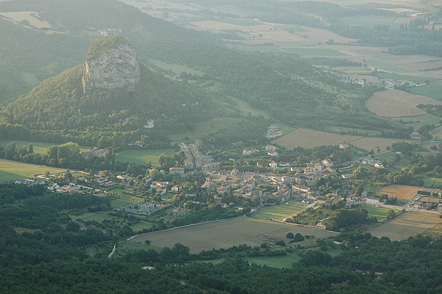
Mornans is a picturesque village in the Drôme department of the Auvergne-Rhône-Alpes region in southeastern France. It is known for its beautiful natural surroundings, making it a great destination for hiking enthusiasts. Here are some highlights of hiking in and around Mornans:
Trails and Terrain
-
Varied Terrain: The region features a mix of terrains, including wooded areas, rocky paths, and open fields, providing diverse hiking experiences suitable for different skill levels.
-
Local Trails: Trails around Mornans often feature stunning views of the surrounding mountains and valleys. The paths can lead you through charming local villages and offer glimpses of rural French life.
-
Topography: The area around Mornans has rolling hills and gentle slopes, making it suitable for both casual hikers and more experienced adventurers looking for a moderate challenge.
Popular Hikes
-
Circuit des Crêts: This trail leads hikers through varied landscapes, with opportunities to enjoy panoramic views of the Vercors mountains and the surrounding countryside.
-
Rochefort-en-Valdaine: A slightly longer hike that takes you to the neighboring village, perfect for those looking to explore more of the region.
-
Drôme Valley: Explore routes that lead to areas with river views, where you might spot local wildlife.
Best Practices
- Footwear: Wear appropriate hiking boots to tackle different terrains comfortably.
- Maps and Markings: Make sure to have a detailed map and check for trail markings, as some trails may not be well-defined.
- Weather Awareness: The weather can change quickly in this region, so be prepared with layers and rain gear.
Additional Recommendations
- Local Guides: Consider hiring a local guide who knows the terrain and can share insights about the area’s natural history and flora and fauna.
- Hydration and Snacks: Always carry enough water and some snacks, especially if you plan to hike longer trails.
Conclusion
Mornans offers beautiful hiking opportunities for nature lovers, providing a chance to connect with the stunning landscapes of the Drôme region. Whether you're a beginner or an experienced hiker, you'll find trails that cater to your skill level and allow you to enjoy the natural beauty of southeastern France. Always remember to practice Leave No Trace principles to help preserve the area for future hikers. Happy hiking!
- Country:

- Postal Code: 26460
- Coordinates: 44° 37' 12" N, 5° 7' 30" E


- GPS tracks (wikiloc): [Link]
- Area: 11.72 sq km
- Population: 70
- Wikipedia en: wiki(en)
- Wikipedia: wiki(fr)
- Wikidata storage: Wikidata: Q475878
- Wikipedia Commons Category: [Link]
- Freebase ID: [/m/03mgjsc]
- GeoNames ID: Alt: [6430154]
- SIREN number: [212602148]
- BnF ID: [15253075v]
- INSEE municipality code: 26214
Shares border with regions:


Francillon-sur-Roubion
- commune in Drôme, France
Hiking in Francillon-sur-Roubion
Francillon-sur-Roubion is a charming village located in the Drôme department of the Auvergne-Rhône-Alpes region in France. It's a great area for those interested in hiking, with its picturesque landscapes and varied terrain....
- Country:
- Postal Code: 26400
- Coordinates: 44° 37' 26" N, 5° 5' 11" E
- GPS tracks (wikiloc): [Link]
- Area: 10.8 sq km
- Population: 186
Bézaudun-sur-Bîne
- commune in Drôme, France
Hiking in Bézaudun-sur-Bîne
Bézaudun-sur-Bîne is a charming commune located in the Auvergne-Rhône-Alpes region of France, nestled in the picturesque landscape of the French Alps. This area offers a range of hiking opportunities for all levels of experience, surrounded by stunning natural scenery, including forests, valleys, and panoramic mountain views....
- Country:
- Postal Code: 26460
- Coordinates: 44° 35' 47" N, 5° 9' 55" E
- GPS tracks (wikiloc): [Link]
- Area: 17.97 sq km
- Population: 76


Bourdeaux
- commune in Drôme, France
Hiking in Bourdeaux
Bordeaux, while primarily known for its wine and culinary scene, also offers some beautiful hiking opportunities in and around the city, as well as in the broader Aquitaine region of southwestern France. Here are some highlights:...
- Country:
- Postal Code: 26460
- Coordinates: 44° 35' 11" N, 5° 8' 4" E
- GPS tracks (wikiloc): [Link]
- Area: 23.11 sq km
- Population: 626

Saou
- commune in Drôme, France
Hiking in Saou
Saou is a picturesque village located in the Drôme department of southeastern France, known for its stunning natural beauty, particularly its limestone cliffs and rolling hills. Hiking in Saou offers a mix of scenic views, diverse landscapes, and historical sites, making it a great destination for outdoor enthusiasts....
- Country:
- Postal Code: 26400
- Coordinates: 44° 38' 45" N, 5° 3' 44" E
- GPS tracks (wikiloc): [Link]
- Area: 41.6 sq km
- Population: 541


Le Poët-Célard
- commune in Drôme, France
Hiking in Le Poët-Célard
Le Poët-Célard is a charming and scenic village located in the Drôme department of southeastern France. Nestled in the foothills of the Vercors Massif, this area offers beautiful landscapes and a variety of hiking opportunities for outdoor enthusiasts....
- Country:
- Postal Code: 26460
- Coordinates: 44° 36' 7" N, 5° 6' 13" E
- GPS tracks (wikiloc): [Link]
- Area: 8.34 sq km
- Population: 124