
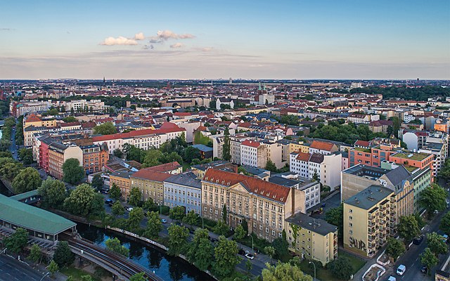
Friedrichshain-Kreuzberg (Friedrichshain-Kreuzberg)
.svg)

- borough of Berlin, Germany
 Hiking in Friedrichshain-Kreuzberg
Friedrichshain-Kreuzberg is a vibrant district in Berlin, known for its rich culture, street art, and diverse communities rather than traditional hiking trails. However, it does offer some great opportunities for walking and exploring. Here are some options for those looking to enjoy urban hiking in this area:
-
Tempelhofer Feld: This former airport has been converted into a massive public park where you can walk, run, or cycle. Its expansive open spaces are perfect for leisurely hikes, picnics, and enjoying nature in an urban environment.
-
Volkspark Friedrichshain: This park features various paths winding through wooded areas, grassy fields, and beautiful fountains. It's an excellent place for a peaceful hike within the city, with spots for relaxation and enjoying greenery.
-
The Landwehr Canal: Walking along the canal offers a scenic route with lots of interesting views, cafés, and spots to take breaks. It’s a lovely way to explore the neighborhoods of Friedrichshain and Kreuzberg while enjoying the water.
-
East Side Gallery: While not a hiking trail, walking along this section of the Berlin Wall is a unique historical experience. The murals that cover the wall provide insights into Berlin's history and artistic expression.
-
Street Art Tours: Friedrichshain-Kreuzberg is famous for its street art. You might consider a self-guided tour of the area’s many murals and graffiti pieces, weaving in and out of alleys and neighborhoods while learning about the local culture.
-
Hiking in Nearby Parks: If you're looking for more substantial nature experiences, you might consider venturing slightly outside the area to places like Grunewald or the Müggelberge hills, which offer more traditional hiking routes.
When hiking or walking in urban environments like Friedrichshain-Kreuzberg, remember to stay hydrated, wear comfortable shoes, and keep an eye on your surroundings, especially when exploring less populated areas. Happy hiking!
- Country:

- Coordinates: 52° 30' 0" N, 13° 27' 0" E


- GPS tracks (wikiloc): [Link]
- Area: 20.2 sq km
- Population: 281076
- Web site: http://www.friedrichshain-kreuzberg.de
- Wikipedia en: wiki(en)
- Wikipedia: wiki(de)
- Wikidata storage: Wikidata: Q158893
- Wikipedia Commons Gallery: [Link]
- Wikipedia Commons Category: [Link]
- Wikipedia Commons Maps Category: [Link]
- Freebase ID: [/m/022n8j]
- GeoNames ID: Alt: [3336295]
- VIAF ID: Alt: [234812069]
- OSM relation ID: [55764]
- GND ID: Alt: [7571574-0]
- archINFORM location ID: [43207]
- Library of Congress authority ID: Alt: [n2004033994]
- TGN ID: [7032552]
- BabelNet ID: [03112118n]
Includes regions:

Kreuzberg
- locality of Berlin, Germany
Hiking in Kreuzberg
Kreuzberg is a vibrant neighborhood in Berlin, Germany, known for its diverse culture, arts, and nightlife. While it’s primarily an urban area, there are some great outdoor spaces for walking and hiking enthusiasts....
- Country:
- Postal Code: 10969; 10999; 10997; 10967; 10965; 10963; 10961
- Coordinates: 52° 29' 15" N, 13° 23' 0" E
- GPS tracks (wikiloc): [Link]
- AboveSeaLevel: 52 м m
- Area: 10.38 sq km
- Population: 153887


Friedrichshain
- locality of Berlin
Hiking in Friedrichshain
Friedrichshain is a vibrant neighborhood in Berlin, Germany, known more for its urban atmosphere, parks, and nightlife than for traditional hiking trails. However, there are still plenty of opportunities for walking and enjoying the outdoors in this area....
- Country:
- Postal Code: 10317; 10179; 10178; 10249; 10247; 10245; 10243
- Coordinates: 52° 30' 57" N, 13° 27' 15" E
- GPS tracks (wikiloc): [Link]
- AboveSeaLevel: 41 м m
- Area: 9.78 sq km
- Population: 125169
Shares border with regions:

Treptow-Köpenick
- borough of Berlin, Germany
Hiking in Treptow-Köpenick
Treptow-Köpenick, located in the southeastern part of Berlin, is a picturesque district known for its natural beauty and recreational opportunities, making it an excellent area for hiking and enjoying the outdoors....
- Country:
- Coordinates: 52° 27' 0" N, 13° 34' 0" E
- GPS tracks (wikiloc): [Link]
- Area: 168 sq km
- Web site: [Link]


Tempelhof-Schöneberg
- borough of Berlin, Germany
Hiking in Tempelhof-Schöneberg
Tempelhof-Schöneberg is a unique district in Berlin, known more for its urban environment than traditional hiking trails. However, it does offer opportunities for outdoor activities and scenic walks. Here are some highlights for exploring the area on foot:...
- Country:
- Coordinates: 52° 28' 0" N, 13° 23' 0" E
- GPS tracks (wikiloc): [Link]
- Area: 531 sq km
- Web site: [Link]

Pankow
- borough of Berlin, Germany
Hiking in Pankow
Pankow is a borough in Berlin, Germany, and while it's primarily known for its urban environment, there are some options for hiking and enjoying nature in the area or nearby. Here are a few suggestions for hiking and outdoor activities around Pankow:...
- Country:
- Licence Plate Code: B
- Coordinates: 52° 34' 0" N, 13° 24' 0" E
- GPS tracks (wikiloc): [Link]
- Area: 103 sq km
- Web site: [Link]


Mitte
- borough of Berlin, Germany
Hiking in Mitte
Mitte is a central borough of Berlin, Germany, and while it's better known for its urban environment, historical landmarks, and museums, there are some nearby outdoor opportunities for hiking and nature exploration. Here are a few options for enjoying a hike around Mitte and the surrounding areas:...
- Country:
- Coordinates: 52° 31' 0" N, 13° 22' 0" E
- GPS tracks (wikiloc): [Link]
- Area: 39.5 sq km
- Population: 333905
- Web site: [Link]

Lichtenberg
- borough of Berlin, Germany
Hiking in Lichtenberg
Lichtenberg is a beautiful region that offers various hiking opportunities, especially notable in both natural beauty and cultural significance. While there are different locations and contexts for Lichtenberg (such as a district in Berlin or other areas named Lichtenberg), I'll focus on general hiking aspects that you might find in such areas....
- Country:
- Coordinates: 52° 32' 0" N, 13° 30' 0" E
- GPS tracks (wikiloc): [Link]
- Area: 52.11 sq km
- Population: 275142
- Web site: [Link]

Neukölln
- borough of Berlin, Germany
Hiking in Neukölln
Neukölln is one of the most vibrant districts in Berlin, Germany, known for its diverse culture, artistic scenes, and community spaces. While it's not traditionally associated with hiking in the classic sense, there are still some great outdoor activities and parks in the area that can provide a satisfying experience for those looking to enjoy nature and explore on foot....
- Country:
- Coordinates: 52° 29' 0" N, 13° 27' 0" E
- GPS tracks (wikiloc): [Link]
- Area: 44.9 sq km
- Population: 306000
- Web site: [Link]