
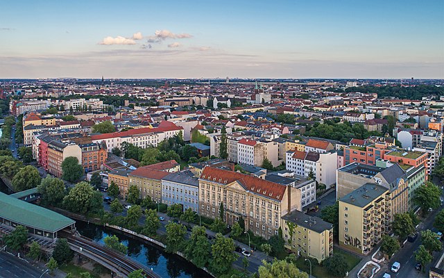
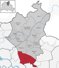
Friedrichshain (Friedrichshain)

- locality of Berlin
 Hiking in Friedrichshain
Friedrichshain is a vibrant neighborhood in Berlin, Germany, known more for its urban atmosphere, parks, and nightlife than for traditional hiking trails. However, there are still plenty of opportunities for walking and enjoying the outdoors in this area.
Key Highlights for Hiking in Friedrichshain:
-
Volkspark Friedrichshain: This is the largest park in the Friedrichshain district and a great spot for those looking for a more relaxed hiking experience. It features winding paths, wooded areas, and a beautiful park landscape. You can take leisurely walks or more vigorous hikes here, exploring the park's hills, gardens, and monuments.
-
Riverside Walking: The eastern banks of the River Spree are easily accessible from Friedrichshain. A walk along the river not only offers beautiful views of the water but also allows you to experience Berlin's unique waterfront architecture and atmosphere.
-
Wandering the Streets: Although not traditional hiking, exploring the streets of Friedrichshain can be just as rewarding. The area is known for its street art, independent shops, and cafes. Walking through the lively neighborhoods can be a great way to experience local culture.
-
Nearby Treptower Park: If you're willing to venture slightly outside Friedrichshain, Treptower Park is a fantastic place for walking and hiking. It offers large green spaces, scenic paths, and beautiful river views. You can also enjoy the historic Soviet War Memorial located within the park.
-
Landschaftspark 'Grün Berlin': This network of green spaces in the city includes various parks and nature areas. You can plan a scenic walk that connects several parks, combining urban hiking with nature experiences.
Tips for Hiking in Friedrichshain:
- Wear Comfortable Shoes: Whether you’re venturing through parks or urban paths, good footwear is essential.
- Plan Your Route: Maps are available for the parks and bike paths, which can help you plan a longer hike or a loop back to your starting point.
- Stay Hydrated: Always carry water, especially if you're planning a longer walk.
- Explore Local Food Spots: After your hike, treat yourself to some local cuisine at the many cafes and restaurants in the area.
While Friedrichshain may not offer mountainous terrain or traditional hiking trails, it provides a unique walking experience that captures the spirit of Berlin. Enjoy your outdoor adventures!
- Country:

- Postal Code: 10317; 10179; 10178; 10249; 10247; 10245; 10243
- Coordinates: 52° 30' 57" N, 13° 27' 15" E


- GPS tracks (wikiloc): [Link]
- AboveSeaLevel: 41 м m
- Area: 9.78 sq km
- Population: 125169
- Wikipedia en: wiki(en)
- Wikipedia: wiki(de)
- Wikidata storage: Wikidata: Q317056
- Wikipedia Commons Gallery: [Link]
- Wikipedia Commons Category: [Link]
- Wikipedia Commons Maps Category: [Link]
- Freebase ID: [/m/03mxcn]
- GeoNames ID: Alt: [2924573]
- VIAF ID: Alt: [242553271]
- GND ID: Alt: [4087311-0]
- archINFORM location ID: [3423]
Shares border with regions:


Mitte
- locality in the borough of Mitte, Berlin, Germany
Hiking in Mitte
Mitte is the central borough of Berlin, Germany, and while it is primarily an urban area known for its historical sites, museums, and vibrant culture, there are still opportunities for outdoor activities, including hiking, especially if you're willing to explore nearby green spaces and parks....
- Country:
- Postal Code: 10179; 10178; 10119; 10117; 10115
- Licence Plate Code: B
- Coordinates: 52° 31' 10" N, 13° 24' 24" E
- GPS tracks (wikiloc): [Link]
- AboveSeaLevel: 48 м m
- Area: 10.69 sq km
- Population: 89757

Kreuzberg
- locality of Berlin, Germany
Hiking in Kreuzberg
Kreuzberg is a vibrant neighborhood in Berlin, Germany, known for its diverse culture, arts, and nightlife. While it’s primarily an urban area, there are some great outdoor spaces for walking and hiking enthusiasts....
- Country:
- Postal Code: 10969; 10999; 10997; 10967; 10965; 10963; 10961
- Coordinates: 52° 29' 15" N, 13° 23' 0" E
- GPS tracks (wikiloc): [Link]
- AboveSeaLevel: 52 м m
- Area: 10.38 sq km
- Population: 153887

Prenzlauer Berg
- locality of Berlin
Hiking in Prenzlauer Berg
Prenzlauer Berg, a vibrant district in Berlin, is primarily known for its urban environment, charming architecture, and lively atmosphere rather than traditional hiking trails. However, there are plenty of opportunities for enjoyable walks and exploration in this area. Here are some aspects to consider if you're looking to hike or walk in Prenzlauer Berg:...
- Country:
- Coordinates: 52° 32' 3" N, 13° 25' 7" E
- GPS tracks (wikiloc): [Link]
- AboveSeaLevel: 54 м m
- Area: 11 sq km
- Population: 156910

Plänterwald
- locality of Berlin
Hiking in Plänterwald
Plänterwald is a beautiful green area located in Berlin, Germany, particularly known for its scenic landscapes and unique blend of nature and urban environment. While it may not be the first location that comes to mind for hiking, it offers a number of trails and paths that can be enjoyable for walkers and nature enthusiasts....
- Country:
- Coordinates: 52° 28' 47" N, 13° 28' 31" E
- GPS tracks (wikiloc): [Link]
- AboveSeaLevel: 31 м m
- Area: 3.01 sq km


Rummelsburg
- locality of Berlin
Hiking in Rummelsburg
Rummelsburg is a neighborhood in Berlin, Germany, known more for its urban environment than traditional hiking trails. However, if you're looking for hiking-like experiences in and around Rummelsburg, there are a few options worth considering:...
- Country:
- Coordinates: 52° 30' 0" N, 13° 29' 33" E
- GPS tracks (wikiloc): [Link]
- AboveSeaLevel: 40 м m
- Area: 4.52 sq km


Alt-Treptow
- locality of Berlin
Hiking in Alt-Treptow
Alt-Treptow, a district in Berlin, offers a variety of hiking and walking opportunities, particularly along the banks of the Spree River and through its green parks. While it may not be as rugged as traditional hiking destinations, it provides pleasant routes for leisurely walks, nature walks, and urban hiking experiences. Here are some highlights for hiking in Alt-Treptow:...
- Country:
- Coordinates: 52° 29' 24" N, 13° 26' 58" E
- GPS tracks (wikiloc): [Link]
- AboveSeaLevel: 36 м m
- Area: 2.31 sq km
- Population: 10859


Lichtenberg
- locality of borough Lichtenberg of Berlin, Germany
Hiking in Lichtenberg
Lichtenberg is a picturesque locality located in the region of Brandenburg, Germany. It is situated near the capital city, Berlin, making it a popular destination for day-trippers and hikers looking to escape the urban environment....
- Country:
- Coordinates: 52° 31' 16" N, 13° 28' 48" E
- GPS tracks (wikiloc): [Link]
- AboveSeaLevel: 52 м m
- Area: 7.22 sq km
- Population: 39121