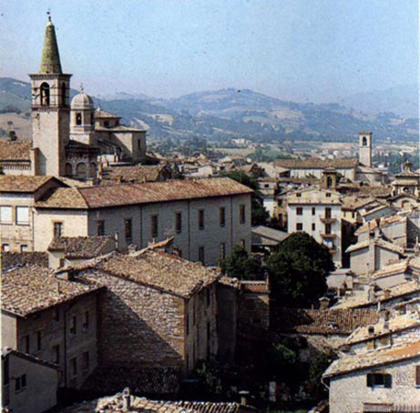
Frontone (Frontone)

- Italian comune
 Hiking in Frontone
Frontone, a charming village in the Marche region of Italy, offers a variety of hiking opportunities for enthusiasts of all levels. Nestled in the Apennine Mountains, it boasts stunning landscapes, rich history, and breathtaking views.
Hiking Trails
-
Monte Catria:
- Distance: Varies depending on the route, typically around 10-15 km round trip.
- Difficulty: Moderate.
- Highlights: This hike leads you to the summit of Monte Catria, where you can enjoy panoramic views of the surrounding countryside and the Adriatic Sea on clear days. The trail is well-marked and offers a mix of forested paths and rocky terrain.
-
Castello di Frontone Trail:
- Distance: Approximately 5 km.
- Difficulty: Easy.
- Highlights: A short, scenic hike that takes you to the historic castle overviewing Frontone. The trail is suitable for families and provides insights into the region's medieval history while enjoying lovely views of the valley.
-
Sentiero della Val d'Esino:
- Distance: Around 20 km (can be done in segments).
- Difficulty: Moderate to challenging.
- Highlights: This longer hike follows the Esino River, passing through picturesque villages and offering opportunities to spot local wildlife and plant life. Suitable for those looking for a full-day adventure.
General Tips
- Best Time to Hike: Spring (April to June) and fall (September to October) are ideal due to mild temperatures and beautiful scenery.
- Gear: Sturdy hiking boots, weather-appropriate clothing, and plenty of water are essential. A map or GPS device is also advisable.
- Safety: Be aware of the weather conditions and check local advisories. It’s also a good idea to inform someone of your hiking plans.
Additional Attractions
After your hikes, consider exploring the local area:
- Local Cuisine: Enjoy traditional Marche dishes in Frontone's quaint restaurants or taverns.
- Cultural Sites: Visit the historic castle or the nearby abbeys and churches to learn about the region’s history.
Whether you're looking for a leisurely stroll or a challenging hike, Frontone provides a beautiful backdrop for an unforgettable outdoor experience.
- Country:

- Postal Code: 61040
- Local Dialing Code: 0721
- Licence Plate Code: PU
- Coordinates: 43° 30' 52" N, 12° 44' 18" E


- GPS tracks (wikiloc): [Link]
- AboveSeaLevel: 412 м m
- Area: 36.08 sq km
- Population: 1293
- Web site: http://www.comune.frontone.pu.it/
- Wikipedia en: wiki(en)
- Wikipedia: wiki(it)
- Wikidata storage: Wikidata: Q206951
- Wikipedia Commons Category: [Link]
- Freebase ID: [/m/0gl46r]
- GeoNames ID: Alt: [6538493]
- VIAF ID: Alt: [122973369]
- OSM relation ID: [42459]
- ISTAT ID: 041018
- Italian cadastre code: D808
Shares border with regions:

Cagli
- Italian comune
Hiking in Cagli
Cagli, a charming town in the Marche region of Italy, is surrounded by beautiful natural landscapes, making it a great destination for hiking enthusiasts. The area is characterized by rolling hills, lush forests, and scenic views that are perfect for both novice and experienced hikers....
- Country:
- Postal Code: 61043
- Local Dialing Code: 0721
- Licence Plate Code: PU
- Coordinates: 43° 32' 49" N, 12° 38' 50" E
- GPS tracks (wikiloc): [Link]
- AboveSeaLevel: 276 м m
- Area: 226.46 sq km
- Population: 8546
- Web site: [Link]


Cantiano
- comune of Italy
Hiking in Cantiano
Cantiano is a charming town located in the Marche region of Italy, surrounded by the beautiful landscapes of the Apennine Mountains. It's a great destination for hiking enthusiasts, offering a variety of trails that cater to different skill levels and preferences....
- Country:
- Postal Code: 61044
- Local Dialing Code: 0721
- Licence Plate Code: PU
- Coordinates: 43° 28' 21" N, 12° 37' 43" E
- GPS tracks (wikiloc): [Link]
- AboveSeaLevel: 360 м m
- Area: 83.25 sq km
- Population: 2206
- Web site: [Link]

Scheggia e Pascelupo
- Italian comune
Hiking in Scheggia e Pascelupo
Scheggia e Pascelupo is a picturesque municipality located in the Umbria region of Italy, renowned for its scenic landscapes, lush forests, and rugged hills. It is part of the larger Monte Cucco Regional Park, which offers a diverse array of outdoor activities, including hiking....
- Country:
- Postal Code: 06027
- Local Dialing Code: 075
- Licence Plate Code: PG
- Coordinates: 43° 24' 13" N, 12° 39' 57" E
- GPS tracks (wikiloc): [Link]
- AboveSeaLevel: 580 м m
- Area: 64.16 sq km
- Population: 1349
- Web site: [Link]


Pergola, Marche
- Italian comune
Hiking in Pergola, Marche
Pergola, located in the Marche region of Italy, is a charming town nestled in the rolling hills and surrounded by beautiful landscapes, making it an excellent destination for hiking enthusiasts. Here are some highlights about hiking in the area:...
- Country:
- Postal Code: 61045
- Local Dialing Code: 0721
- Licence Plate Code: PU
- Coordinates: 43° 33' 51" N, 12° 50' 5" E
- GPS tracks (wikiloc): [Link]
- AboveSeaLevel: 265 м m
- Area: 112.4 sq km
- Population: 6200
- Web site: [Link]


Serra Sant'Abbondio
- Italian comune
Hiking in Serra Sant'Abbondio
Serra Sant'Abbondio is a beautiful area located in the Marche region of Italy, known for its stunning landscapes, rich natural diversity, and charming villages. When it comes to hiking in this region, there are plenty of trails that cater to various skill levels, offering both easy walks and more challenging hikes....
- Country:
- Postal Code: 61040
- Local Dialing Code: 0721
- Licence Plate Code: PU
- Coordinates: 43° 29' 27" N, 12° 46' 14" E
- GPS tracks (wikiloc): [Link]
- AboveSeaLevel: 523 м m
- Area: 32.8 sq km
- Population: 1001
- Web site: [Link]