
Gérardmer (Gérardmer)

- commune in Vosges, France
- Country:

- Postal Code: 88400
- Coordinates: 48° 4' 20" N, 6° 52' 43" E


- GPS tracks (wikiloc): [Link]
- AboveSeaLevel: 670 м m
- Area: 54.78 sq km
- Population: 8294
- Web site: http://mairie-gerardmer.fr
- Wikipedia en: wiki(en)
- Wikipedia: wiki(fr)
- Wikidata storage: Wikidata: Q461219
- Wikipedia Commons Category: [Link]
- Freebase ID: [/m/07yyvf]
- Freebase ID: [/m/07yyvf]
- GeoNames ID: Alt: [3016274]
- GeoNames ID: Alt: [3016274]
- SIREN number: [218801967]
- SIREN number: [218801967]
- BnF ID: [15279123r]
- BnF ID: [15279123r]
- VIAF ID: Alt: [167414749]
- VIAF ID: Alt: [167414749]
- GND ID: Alt: [4217106-4]
- GND ID: Alt: [4217106-4]
- Library of Congress authority ID: Alt: [n80053110]
- Library of Congress authority ID: Alt: [n80053110]
- MusicBrainz area ID: [187dd823-bda1-476f-a797-50a3da061fc5]
- MusicBrainz area ID: [187dd823-bda1-476f-a797-50a3da061fc5]
- INSEE municipality code: 88196
- INSEE municipality code: 88196
Shares border with regions:


Barbey-Seroux
- commune in Vosges, France
- Country:
- Postal Code: 88640
- Coordinates: 48° 8' 30" N, 6° 50' 22" E
- GPS tracks (wikiloc): [Link]
- Area: 7.32 sq km
- Population: 143


Arrentès-de-Corcieux
- commune in Vosges, France
- Country:
- Postal Code: 88430
- Coordinates: 48° 8' 42" N, 6° 51' 52" E
- GPS tracks (wikiloc): [Link]
- Area: 17 sq km
- Population: 174

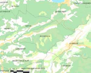
Rochesson
- commune in Vosges, France
- Country:
- Postal Code: 88120
- Coordinates: 48° 1' 20" N, 6° 47' 10" E
- GPS tracks (wikiloc): [Link]
- Area: 21.49 sq km
- Population: 699
- Web site: [Link]


Xonrupt-Longemer
- commune in Vosges, France
- Country:
- Postal Code: 88400
- Coordinates: 48° 4' 50" N, 6° 55' 33" E
- GPS tracks (wikiloc): [Link]
- Area: 30.71 sq km
- Population: 1541
- Web site: [Link]

Liézey
- commune in Vosges, France
- Country:
- Postal Code: 88400
- Coordinates: 48° 5' 37" N, 6° 48' 19" E
- GPS tracks (wikiloc): [Link]
- Area: 13.27 sq km
- Population: 270


La Bresse
- commune in Vosges, France
- Country:
- Postal Code: 88250
- Coordinates: 48° 0' 21" N, 6° 52' 33" E
- GPS tracks (wikiloc): [Link]
- Area: 57.94 sq km
- Population: 4243
- Web site: [Link]


Gerbépal
- commune in Vosges, France
- Country:
- Postal Code: 88430
- Coordinates: 48° 9' 0" N, 6° 55' 19" E
- GPS tracks (wikiloc): [Link]
- Area: 19.18 sq km
- Population: 583
- Web site: [Link]


Sapois
- commune in Vosges, France
- Country:
- Postal Code: 88120
- Coordinates: 48° 1' 11" N, 6° 45' 27" E
- GPS tracks (wikiloc): [Link]
- Area: 16.89 sq km
- Population: 649


Le Tholy
- commune in Vosges, France
- Country:
- Postal Code: 88530
- Coordinates: 48° 4' 59" N, 6° 44' 38" E
- GPS tracks (wikiloc): [Link]
- Area: 30.76 sq km
- Population: 1584
- Web site: [Link]